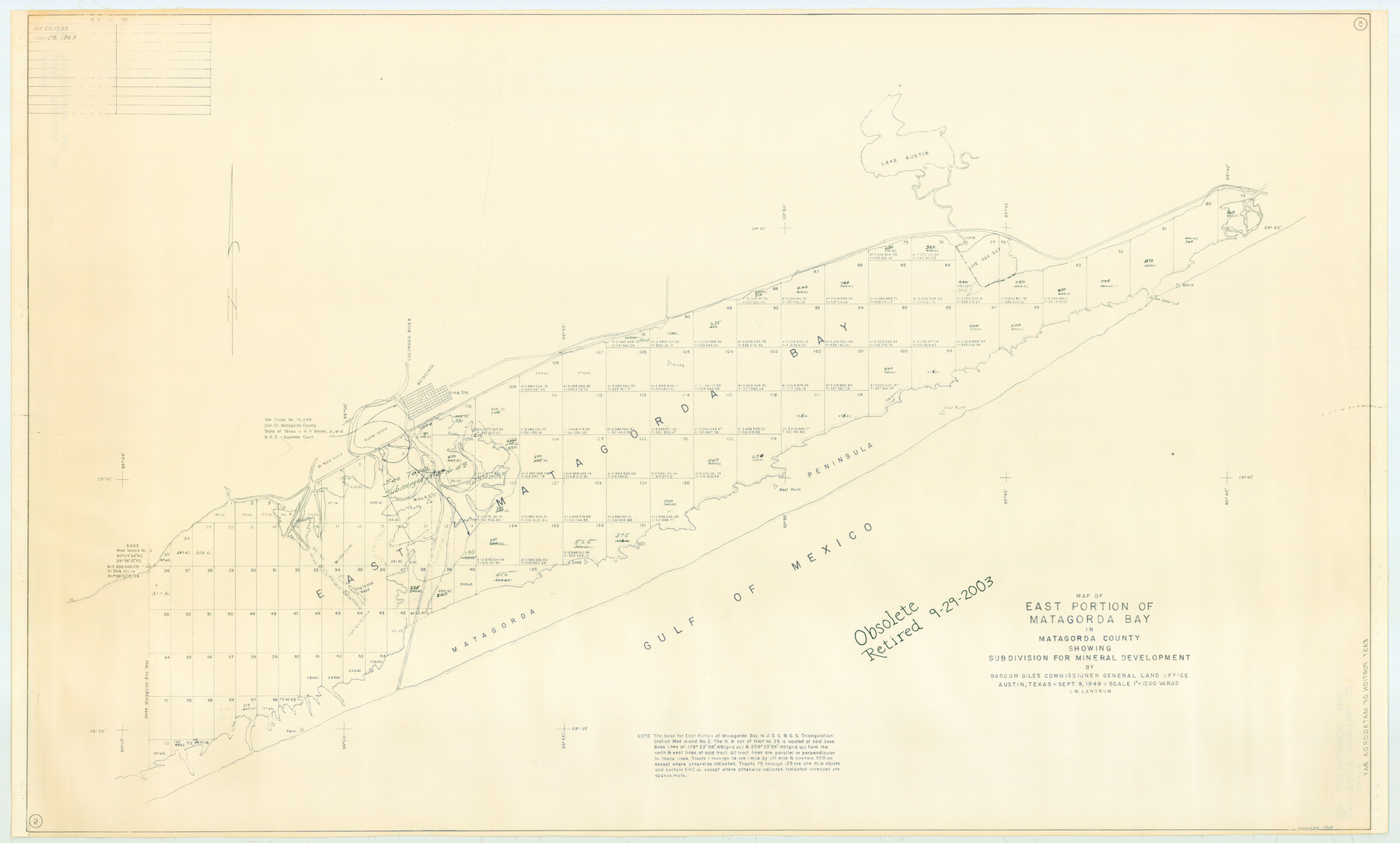
East Portion of Matagorda Bay in Matagorda County, showing Subdivision for Mineral Development
-
Map/Doc
1909
-
Collection
General Map Collection
-
Object Dates
1949 (Creation Date)
-
People and Organizations
General Land Office (Publisher)
-
Subjects
Energy Offshore Submerged Area
-
Height x Width
30.8 x 51.1 inches
78.2 x 129.8 cm
-
Medium
blueline cloth
-
Scale
1200 varas
-
Comments
Gulf coast and submerged state lands. Revised November 26, 1969.
Part of: General Map Collection
Flight Mission No. CUG-2P, Frame 29, Kleberg County

Print $20.00
- Digital $50.00
Flight Mission No. CUG-2P, Frame 29, Kleberg County
1956
Size 18.6 x 22.4 inches
Map/Doc 86194
Pecos County Sketch File 92

Print $4.00
- Digital $50.00
Pecos County Sketch File 92
1954
Size 11.2 x 8.6 inches
Map/Doc 33988
Hartley County

Print $40.00
- Digital $50.00
Hartley County
1923
Size 42.1 x 49.5 inches
Map/Doc 95524
Roberts County Rolled Sketch 7

Print $20.00
- Digital $50.00
Roberts County Rolled Sketch 7
2018
Size 20.1 x 24.1 inches
Map/Doc 97418
Travis County Sketch File 5

Print $4.00
- Digital $50.00
Travis County Sketch File 5
Size 11.0 x 8.2 inches
Map/Doc 38281
Val Verde County Working Sketch 12

Print $20.00
- Digital $50.00
Val Verde County Working Sketch 12
1920
Size 29.0 x 24.3 inches
Map/Doc 72147
Zapata County Working Sketch 19

Print $40.00
- Digital $50.00
Zapata County Working Sketch 19
1976
Size 41.2 x 55.5 inches
Map/Doc 62070
University Land Field Notes for Blocks 19 and 20 in Pecos County

University Land Field Notes for Blocks 19 and 20 in Pecos County
Map/Doc 81724
Angelina County Sketch File 15c

Print $16.00
- Digital $50.00
Angelina County Sketch File 15c
1838
Size 12.2 x 8.0 inches
Map/Doc 12972
Jasper County Sketch File 5

Print $4.00
- Digital $50.00
Jasper County Sketch File 5
Size 8.4 x 12.1 inches
Map/Doc 27770
Flight Mission No. DQO-2K, Frame 136, Galveston County

Print $20.00
- Digital $50.00
Flight Mission No. DQO-2K, Frame 136, Galveston County
1952
Size 18.8 x 22.6 inches
Map/Doc 85033
Duval County Boundary File 1c

Print $12.00
- Digital $50.00
Duval County Boundary File 1c
Size 12.9 x 8.3 inches
Map/Doc 52693
You may also like
Hutchinson County Working Sketch 12

Print $20.00
- Digital $50.00
Hutchinson County Working Sketch 12
1925
Size 20.6 x 29.9 inches
Map/Doc 66370
Menard County Sketch File 4

Print $20.00
- Digital $50.00
Menard County Sketch File 4
Size 18.3 x 25.5 inches
Map/Doc 12072
[Surveys along the Bosque River]
![260, [Surveys along the Bosque River], General Map Collection](https://historictexasmaps.com/wmedia_w700/maps/260.tif.jpg)
Print $2.00
- Digital $50.00
[Surveys along the Bosque River]
1846
Size 9.3 x 7.8 inches
Map/Doc 260
Thomas Kelly Subdivision in Parmer and Castro Counties, Texas

Print $20.00
- Digital $50.00
Thomas Kelly Subdivision in Parmer and Castro Counties, Texas
1906
Size 20.4 x 16.6 inches
Map/Doc 92549
Glasscock County Sketch File 2

Print $20.00
- Digital $50.00
Glasscock County Sketch File 2
1931
Size 35.1 x 16.2 inches
Map/Doc 11559
San Jacinto County Working Sketch 31

Print $20.00
- Digital $50.00
San Jacinto County Working Sketch 31
1953
Size 29.1 x 30.4 inches
Map/Doc 63744
Flight Mission No. DQN-2K, Frame 142, Calhoun County

Print $20.00
- Digital $50.00
Flight Mission No. DQN-2K, Frame 142, Calhoun County
1953
Size 16.3 x 16.0 inches
Map/Doc 84311
Flight Mission No. CGI-4N, Frame 189, Cameron County

Print $20.00
- Digital $50.00
Flight Mission No. CGI-4N, Frame 189, Cameron County
1955
Size 18.5 x 22.2 inches
Map/Doc 84692
Salado, South of Milam

Print $2.00
- Digital $50.00
Salado, South of Milam
1847
Size 11.4 x 8.5 inches
Map/Doc 359
Scurry County Sketch File 1

Print $6.00
- Digital $50.00
Scurry County Sketch File 1
Size 14.5 x 9.1 inches
Map/Doc 36560
Burnet County Sketch File 12

Print $4.00
- Digital $50.00
Burnet County Sketch File 12
1848
Size 12.6 x 7.5 inches
Map/Doc 16694
Reeves County Rolled Sketch 14A

Print $20.00
- Digital $50.00
Reeves County Rolled Sketch 14A
1948
Size 26.0 x 18.9 inches
Map/Doc 7483