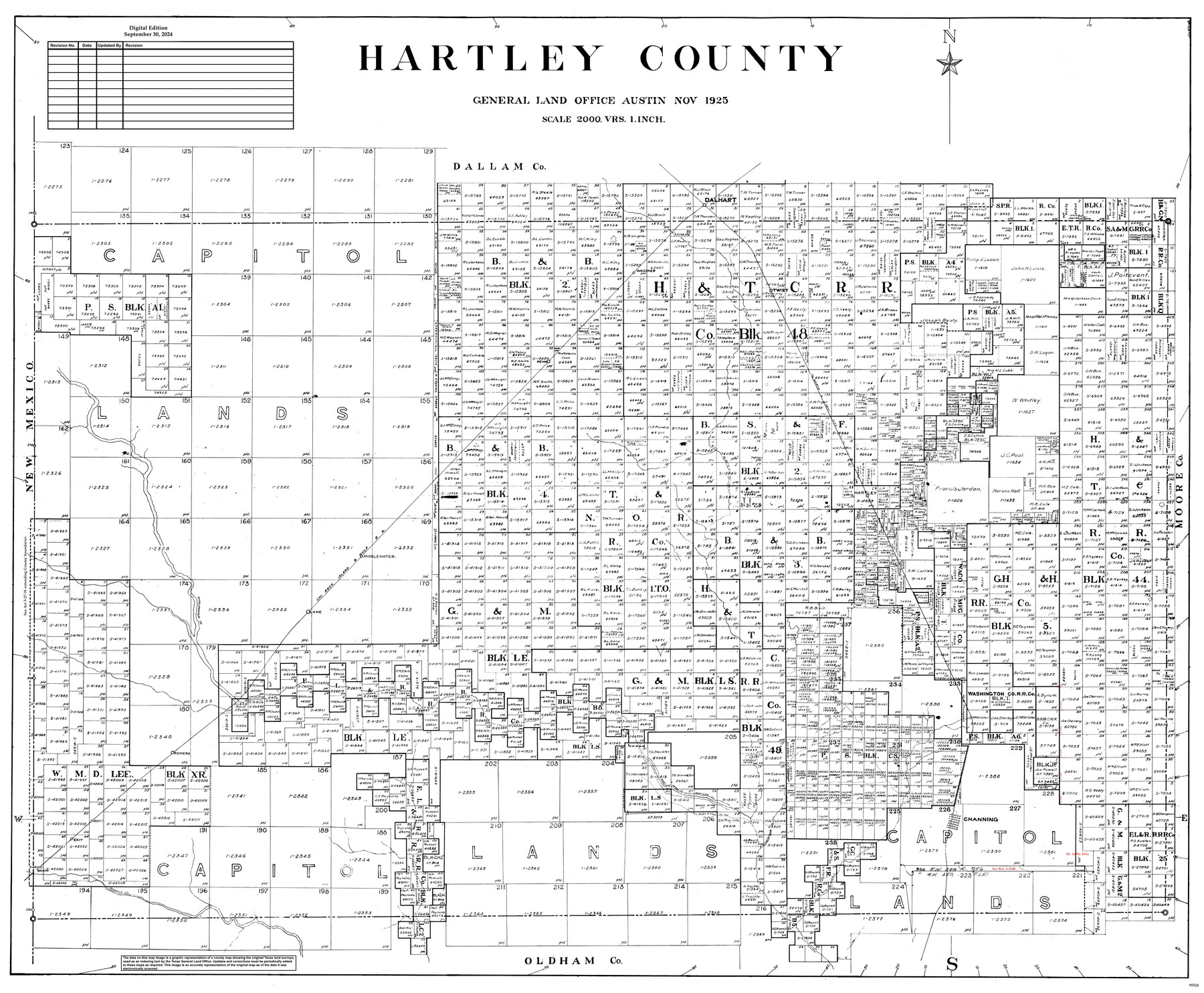
Hartley County
General Land Office Official County Map
-
Map/Doc
95524
-
Collection
General Map Collection
-
Object Dates
11/1923 (Creation Date)
9/30/2024 (Revision Date)
-
People and Organizations
Tom G. Atlee (Compiler)
Tom G. Atlee (Draftsman)
Cheyenne Betancourt (Draftsman)
-
Counties
Hartley
-
Subjects
County OCM
-
Height x Width
42.1 x 49.5 inches
106.9 x 125.7 cm
-
Medium
digital image
-
Scale
1" = 2000 varas
Part of: General Map Collection
San Luis Pass to East Matagorda Bay

Print $20.00
- Digital $50.00
San Luis Pass to East Matagorda Bay
1960
Size 34.6 x 46.5 inches
Map/Doc 69963
Clay County Sketch File 4

Print $22.00
- Digital $50.00
Clay County Sketch File 4
1854
Size 5.0 x 7.5 inches
Map/Doc 18392
Nueces County Rolled Sketch 66

Print $46.00
- Digital $50.00
Nueces County Rolled Sketch 66
1979
Size 26.1 x 37.4 inches
Map/Doc 9608
Brazos County Working Sketch 4

Print $20.00
- Digital $50.00
Brazos County Working Sketch 4
1976
Size 22.5 x 20.6 inches
Map/Doc 67479
Hansford County Working Sketch 3

Print $20.00
- Digital $50.00
Hansford County Working Sketch 3
1940
Size 20.5 x 16.5 inches
Map/Doc 63375
Pecos County Working Sketch 101

Print $20.00
- Digital $50.00
Pecos County Working Sketch 101
1970
Size 43.3 x 31.1 inches
Map/Doc 71574
[Maps of surveys in Reeves & Culberson Cos]
![61134, [Maps of surveys in Reeves & Culberson Cos], General Map Collection](https://historictexasmaps.com/wmedia_w700/maps/61134.tif.jpg)
Print $20.00
- Digital $50.00
[Maps of surveys in Reeves & Culberson Cos]
1937
Size 30.7 x 24.9 inches
Map/Doc 61134
Kendall County Working Sketch 7

Print $20.00
- Digital $50.00
Kendall County Working Sketch 7
1950
Size 30.8 x 32.4 inches
Map/Doc 66679
Rockwall County Working Sketch Graphic Index

Print $20.00
- Digital $50.00
Rockwall County Working Sketch Graphic Index
1941
Size 30.0 x 23.5 inches
Map/Doc 76686
Val Verde County Sketch File N

Print $14.00
- Digital $50.00
Val Verde County Sketch File N
1920
Size 10.9 x 8.8 inches
Map/Doc 39284
Flight Mission No. DQO-7K, Frame 109, Galveston County

Print $20.00
- Digital $50.00
Flight Mission No. DQO-7K, Frame 109, Galveston County
1952
Size 18.7 x 22.4 inches
Map/Doc 85124
Pecos County Working Sketch 37

Print $20.00
- Digital $50.00
Pecos County Working Sketch 37
1939
Size 30.0 x 43.0 inches
Map/Doc 71509
You may also like
Glasscock County Working Sketch 3

Print $20.00
- Digital $50.00
Glasscock County Working Sketch 3
Size 16.8 x 28.0 inches
Map/Doc 63176
Plat Showing Subdivision of Howard County School Land Hockley County, Texas

Print $20.00
- Digital $50.00
Plat Showing Subdivision of Howard County School Land Hockley County, Texas
1947
Size 13.9 x 28.1 inches
Map/Doc 92256
Menard County

Print $20.00
- Digital $50.00
Menard County
1942
Size 40.1 x 43.7 inches
Map/Doc 66928
Concho County Sketch File X

Print $20.00
- Digital $50.00
Concho County Sketch File X
1916
Size 39.4 x 23.7 inches
Map/Doc 11168
Map of Jasper County

Print $40.00
- Digital $50.00
Map of Jasper County
1898
Size 49.1 x 39.6 inches
Map/Doc 66879
Zavala County Working Sketch 11

Print $20.00
- Digital $50.00
Zavala County Working Sketch 11
1955
Size 13.8 x 22.4 inches
Map/Doc 62086
Lamb County Sketch File 14

Print $6.00
- Digital $50.00
Lamb County Sketch File 14
1914
Size 7.3 x 8.7 inches
Map/Doc 29374
King County Boundary File 5

Print $12.00
- Digital $50.00
King County Boundary File 5
Size 14.2 x 8.8 inches
Map/Doc 64916
Hutson Addition to Umbarger, sec. 76, Blk. B-5, Randall Co., Texas

Print $20.00
- Digital $50.00
Hutson Addition to Umbarger, sec. 76, Blk. B-5, Randall Co., Texas
Size 30.5 x 29.5 inches
Map/Doc 92155
Jack County Sketch File 33

Print $20.00
- Digital $50.00
Jack County Sketch File 33
Size 19.5 x 21.4 inches
Map/Doc 11831
Flight Mission No. BRE-1P, Frame 94, Nueces County

Print $20.00
- Digital $50.00
Flight Mission No. BRE-1P, Frame 94, Nueces County
1956
Size 18.6 x 22.4 inches
Map/Doc 86665
Travis County Working Sketch 26

Print $20.00
- Digital $50.00
Travis County Working Sketch 26
1951
Size 34.8 x 25.1 inches
Map/Doc 69410