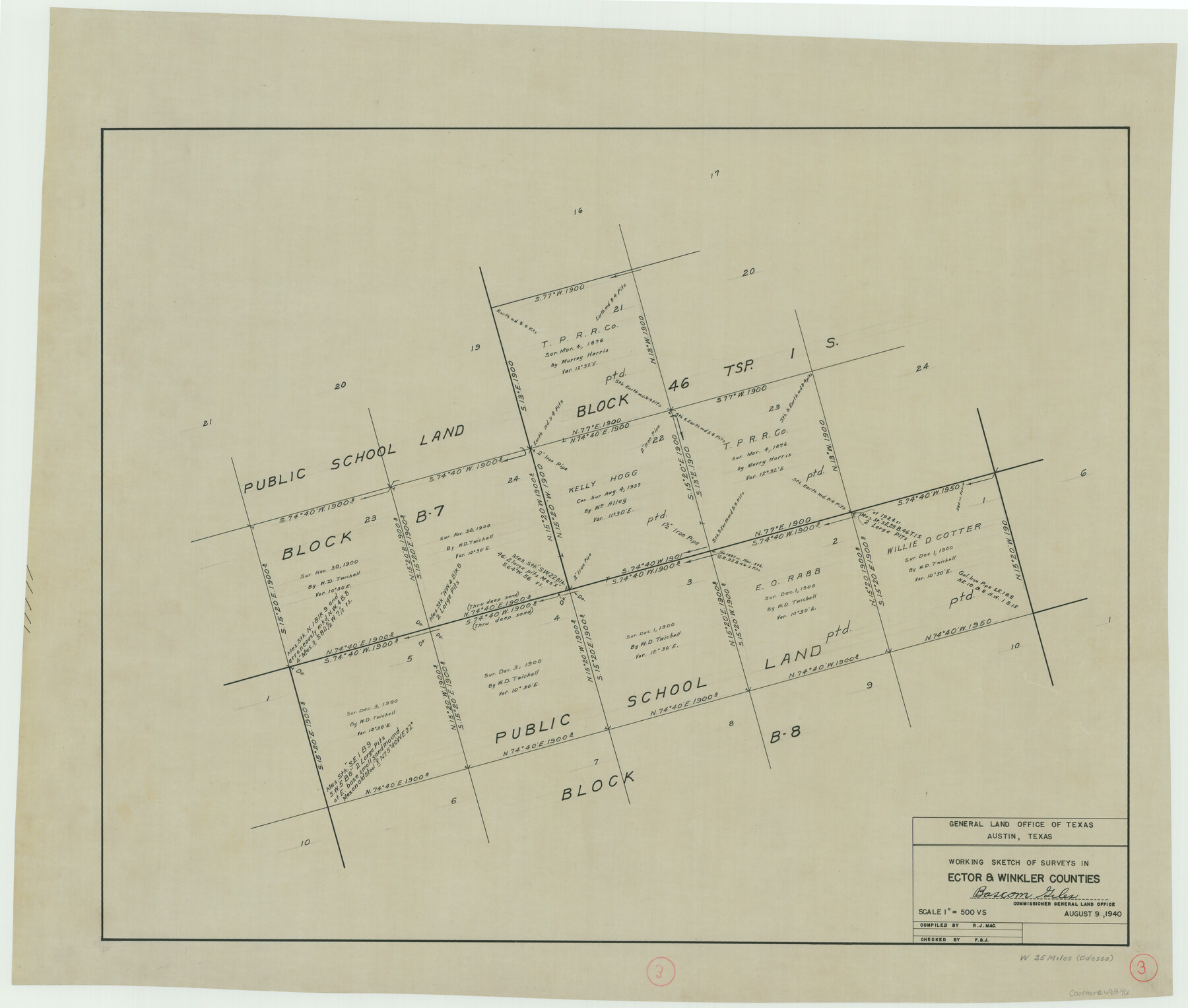
Ector County Working Sketch 3
-
Map/Doc
68846
-
Collection
General Map Collection
-
Object Dates
8/9/1940 (Creation Date)
-
Counties
Ector Winkler
-
Subjects
Surveying Working Sketch
-
Height x Width
26.4 x 31.2 inches
67.1 x 79.3 cm
-
Scale
1" = 500 varas
Part of: General Map Collection
Taylor County Sketch File 8

Print $16.00
- Digital $50.00
Taylor County Sketch File 8
1879
Size 13.9 x 8.7 inches
Map/Doc 37784
Val Verde County Sketch File XXX10

Print $20.00
- Digital $50.00
Val Verde County Sketch File XXX10
Size 25.9 x 19.2 inches
Map/Doc 12549
Edwards County

Print $20.00
- Digital $50.00
Edwards County
1883
Size 28.2 x 17.9 inches
Map/Doc 3505
Hutchinson County

Print $20.00
- Digital $50.00
Hutchinson County
1922
Size 45.4 x 37.6 inches
Map/Doc 95538
Bee County Working Sketch 22

Print $20.00
- Digital $50.00
Bee County Working Sketch 22
1983
Size 37.9 x 37.2 inches
Map/Doc 67272
Medina County Rolled Sketch 2

Print $20.00
- Digital $50.00
Medina County Rolled Sketch 2
1936
Size 31.3 x 28.6 inches
Map/Doc 6739
Comanche County Sketch File 24 1/2

Print $6.00
- Digital $50.00
Comanche County Sketch File 24 1/2
Size 10.5 x 15.8 inches
Map/Doc 19113
Harris County Boundary File 39 (15)

Print $8.00
- Digital $50.00
Harris County Boundary File 39 (15)
Size 7.2 x 8.3 inches
Map/Doc 54350
Brooks County Rolled Sketch 22

Print $20.00
- Digital $50.00
Brooks County Rolled Sketch 22
1943
Size 15.1 x 32.2 inches
Map/Doc 5343
Map of Cameron County

Print $40.00
- Digital $50.00
Map of Cameron County
1880
Size 50.3 x 26.5 inches
Map/Doc 4786
Harris County Rolled Sketch 40

Print $20.00
- Digital $50.00
Harris County Rolled Sketch 40
1913
Size 20.3 x 23.1 inches
Map/Doc 6098
Lampasas County Boundary File 1

Print $4.00
- Digital $50.00
Lampasas County Boundary File 1
Size 10.2 x 8.2 inches
Map/Doc 56093
You may also like
Tom Green County Sketch File 89

Print $4.00
Tom Green County Sketch File 89
Size 14.3 x 8.9 inches
Map/Doc 97245
Township 13 South Ranges 14 and 15 West, South Western District, Louisiana

Print $20.00
- Digital $50.00
Township 13 South Ranges 14 and 15 West, South Western District, Louisiana
1838
Size 19.6 x 24.8 inches
Map/Doc 65857
Cooke County Working Sketch 19

Print $20.00
- Digital $50.00
Cooke County Working Sketch 19
1954
Size 23.8 x 20.7 inches
Map/Doc 68256
Nueva Hispania Tabula Nova

Print $20.00
- Digital $50.00
Nueva Hispania Tabula Nova
1561
Size 9.4 x 12.3 inches
Map/Doc 93796
Castro County Sketch File 6

Print $20.00
- Digital $50.00
Castro County Sketch File 6
Size 20.8 x 15.6 inches
Map/Doc 11059
Hall County Rolled Sketch 9

Print $20.00
- Digital $50.00
Hall County Rolled Sketch 9
1946
Size 22.0 x 40.4 inches
Map/Doc 6053
Capitol Land Reservation

Print $40.00
- Digital $50.00
Capitol Land Reservation
1880
Size 115.6 x 36.6 inches
Map/Doc 10785
Rhyne Simpson Quirt Ave. Addition to the City of Lubbock

Print $20.00
- Digital $50.00
Rhyne Simpson Quirt Ave. Addition to the City of Lubbock
1951
Size 17.2 x 21.2 inches
Map/Doc 92878
Coleman County Working Sketch 24

Print $40.00
- Digital $50.00
Coleman County Working Sketch 24
1989
Size 43.1 x 54.3 inches
Map/Doc 68277
[Ector County Line Descriptions]
![92636, [Ector County Line Descriptions], Twichell Survey Records](https://historictexasmaps.com/wmedia_w700/maps/92636-1.tif.jpg)
Print $20.00
- Digital $50.00
[Ector County Line Descriptions]
Size 37.2 x 44.2 inches
Map/Doc 92636
Red River County Working Sketch 47

Print $20.00
- Digital $50.00
Red River County Working Sketch 47
1969
Size 34.3 x 24.2 inches
Map/Doc 72030
Maps of Gulf Intracoastal Waterway, Texas - Sabine River to the Rio Grande and connecting waterways including ship channels

Print $20.00
- Digital $50.00
Maps of Gulf Intracoastal Waterway, Texas - Sabine River to the Rio Grande and connecting waterways including ship channels
1966
Size 14.6 x 22.2 inches
Map/Doc 61958