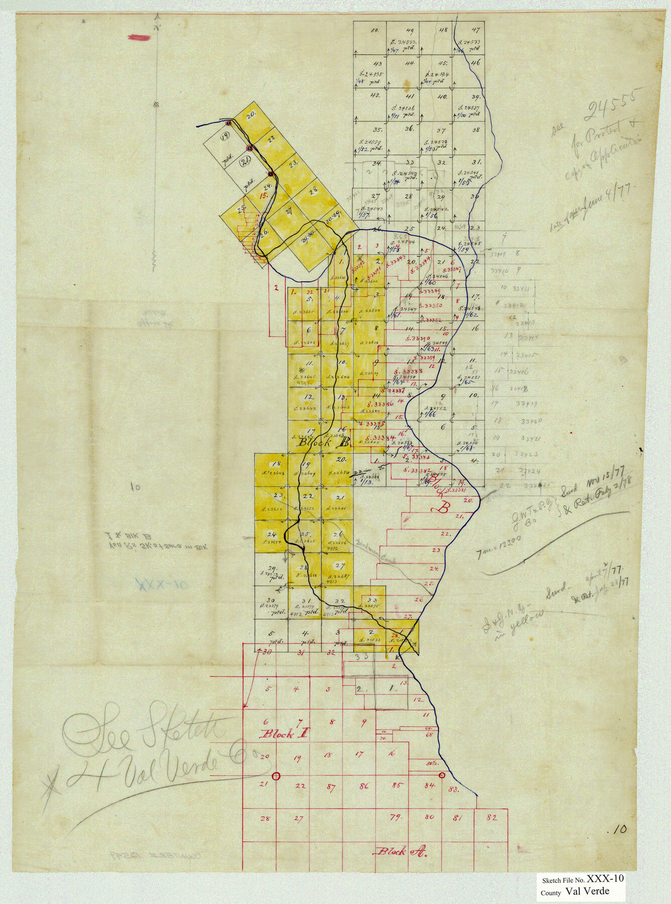
Val Verde County Sketch File XXX10
[Office sketch of surveys in Block 1 and Block B west of Devil's River]
-
Map/Doc
12549
-
Collection
General Map Collection
-
People and Organizations
E. von Rosenberg (Draftsman)
-
Counties
Val Verde
-
Subjects
Surveying Sketch File
-
Height x Width
25.9 x 19.2 inches
65.8 x 48.8 cm
-
Medium
paper, manuscript
Part of: General Map Collection
Brewster County Rolled Sketch 76

Print $20.00
- Digital $50.00
Brewster County Rolled Sketch 76
Size 17.3 x 19.0 inches
Map/Doc 5241
Terrell County Rolled Sketch 25

Print $20.00
- Digital $50.00
Terrell County Rolled Sketch 25
1911
Size 15.7 x 22.7 inches
Map/Doc 7932
Wise County Working Sketch 27

Print $20.00
- Digital $50.00
Wise County Working Sketch 27
1988
Size 28.0 x 37.2 inches
Map/Doc 72641
Brazos River, Brazos River Sheet 4

Print $20.00
- Digital $50.00
Brazos River, Brazos River Sheet 4
1926
Size 19.4 x 32.1 inches
Map/Doc 69668
[Galveston, Harrisburg & San Antonio Railroad from Cuero to Stockdale]
![64191, [Galveston, Harrisburg & San Antonio Railroad from Cuero to Stockdale], General Map Collection](https://historictexasmaps.com/wmedia_w700/maps/64191.tif.jpg)
Print $20.00
- Digital $50.00
[Galveston, Harrisburg & San Antonio Railroad from Cuero to Stockdale]
1907
Size 14.2 x 34.2 inches
Map/Doc 64191
Floyd County Sketch File 15

Print $12.00
- Digital $50.00
Floyd County Sketch File 15
1913
Size 10.9 x 7.3 inches
Map/Doc 22736
Kleberg County Aerial Photograph Index Sheet 1

Print $20.00
- Digital $50.00
Kleberg County Aerial Photograph Index Sheet 1
1956
Size 19.6 x 23.6 inches
Map/Doc 83718
Knox County Working Sketch 3

Print $20.00
- Digital $50.00
Knox County Working Sketch 3
1917
Size 25.0 x 17.0 inches
Map/Doc 70245
Edwards County Working Sketch 79

Print $40.00
- Digital $50.00
Edwards County Working Sketch 79
1962
Size 58.5 x 26.6 inches
Map/Doc 68955
Sutton County Rolled Sketch 54

Print $20.00
- Digital $50.00
Sutton County Rolled Sketch 54
Size 32.4 x 27.7 inches
Map/Doc 7894
Harris County Working Sketch 107

Print $20.00
- Digital $50.00
Harris County Working Sketch 107
1981
Size 46.0 x 28.1 inches
Map/Doc 65999
Brewster County Rolled Sketch 102

Print $20.00
- Digital $50.00
Brewster County Rolled Sketch 102
Size 37.0 x 43.4 inches
Map/Doc 8513
You may also like
Maps of Gulf Intracoastal Waterway, Texas - Sabine River to the Rio Grande and connecting waterways including ship channels

Print $20.00
- Digital $50.00
Maps of Gulf Intracoastal Waterway, Texas - Sabine River to the Rio Grande and connecting waterways including ship channels
1966
Size 14.5 x 22.3 inches
Map/Doc 61977
Central & Montgomery

Print $40.00
- Digital $50.00
Central & Montgomery
1941
Size 26.1 x 123.0 inches
Map/Doc 64523
Map of Chicago, Rock Island & Texas Railroad

Print $40.00
- Digital $50.00
Map of Chicago, Rock Island & Texas Railroad
1892
Size 23.9 x 122.0 inches
Map/Doc 64442
Liberty County Sketch File 68

Print $24.00
- Digital $50.00
Liberty County Sketch File 68
Size 11.0 x 8.5 inches
Map/Doc 94021
Flight Mission No. DQN-7K, Frame 13, Calhoun County

Print $20.00
- Digital $50.00
Flight Mission No. DQN-7K, Frame 13, Calhoun County
1953
Size 18.4 x 22.1 inches
Map/Doc 84464
Map of Coryell Co[unty]
![16951, Map of Coryell Co[unty], General Map Collection](https://historictexasmaps.com/wmedia_w700/maps/16951-1.tif.jpg)
Print $40.00
- Digital $50.00
Map of Coryell Co[unty]
1896
Size 49.8 x 47.7 inches
Map/Doc 16951
Kent County Boundary File 2

Print $4.00
- Digital $50.00
Kent County Boundary File 2
Size 10.1 x 8.2 inches
Map/Doc 55822
Ellis County Sketch File 19

Print $6.00
- Digital $50.00
Ellis County Sketch File 19
1863
Size 12.4 x 7.8 inches
Map/Doc 21866
Terry County Rolled Sketch 5

Print $40.00
- Digital $50.00
Terry County Rolled Sketch 5
Size 56.8 x 38.1 inches
Map/Doc 9995
Starr County Rolled Sketch 35

Print $20.00
- Digital $50.00
Starr County Rolled Sketch 35
1925
Size 40.1 x 12.8 inches
Map/Doc 7832
[South Part of Terrell County, West Part of Val Verde County]
![91960, [South Part of Terrell County, West Part of Val Verde County], Twichell Survey Records](https://historictexasmaps.com/wmedia_w700/maps/91960-1.tif.jpg)
Print $20.00
- Digital $50.00
[South Part of Terrell County, West Part of Val Verde County]
Size 38.6 x 18.5 inches
Map/Doc 91960
Val Verde County Sketch File 30

Print $8.00
- Digital $50.00
Val Verde County Sketch File 30
1933
Size 11.5 x 8.8 inches
Map/Doc 39236