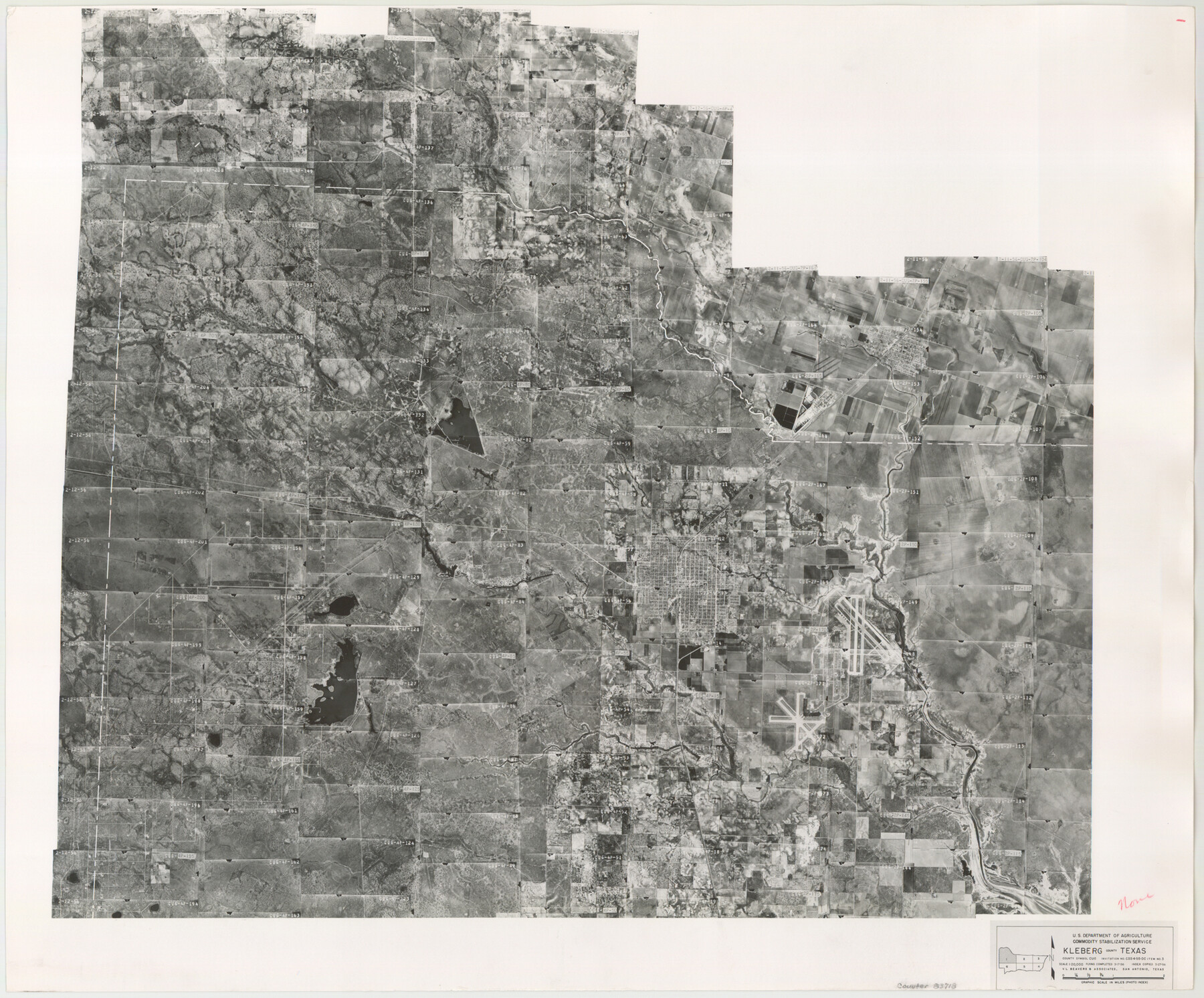
Kleberg County Aerial Photograph Index Sheet 1
Kleberg County Aerial Photograph Index 1
-
Map/Doc
83718
-
Collection
General Map Collection
-
Object Dates
1956/3/27 (Creation Date)
-
People and Organizations
U. S. Department of Agriculture (Publisher)
-
Counties
Kleberg
-
Subjects
Aerial Photograph
-
Height x Width
19.6 x 23.6 inches
49.8 x 59.9 cm
-
Comments
Flying completed March 17, 1956 by V. L. Beavers and Associates of San Antonio, Texas.
Part of: General Map Collection

Polk County Sketch File 30a

Print $8.00
- Digital $50.00
Polk County Sketch File 30a
Size 14.2 x 8.8 inches
Map/Doc 34215
Matagorda Bay and Approaches

Print $20.00
- Digital $50.00
Matagorda Bay and Approaches
1965
Size 34.8 x 44.9 inches
Map/Doc 73383

Flight Mission No. DCL-7C, Frame 23, Kenedy County

Print $20.00
- Digital $50.00
Flight Mission No. DCL-7C, Frame 23, Kenedy County
1943
Size 15.4 x 15.2 inches
Map/Doc 86015
[Overlay for Fractional Township No. 7 South Range No. 17 East of the Indian Meridian, Indian Territory]
![75230, [Overlay for Fractional Township No. 7 South Range No. 17 East of the Indian Meridian, Indian Territory], General Map Collection](https://historictexasmaps.com/wmedia_w700/maps/75230.tif.jpg)
Print $3.00
- Digital $50.00
[Overlay for Fractional Township No. 7 South Range No. 17 East of the Indian Meridian, Indian Territory]
Size 11.2 x 11.7 inches
Map/Doc 75230
King County Working Sketch 11

Print $40.00
- Digital $50.00
King County Working Sketch 11
1971
Size 49.7 x 25.0 inches
Map/Doc 70175
Bandera County Working Sketch 9

Print $20.00
- Digital $50.00
Bandera County Working Sketch 9
1920
Size 15.2 x 17.1 inches
Map/Doc 67602
Presidio County Sketch File 74

Print $8.00
- Digital $50.00
Presidio County Sketch File 74
1946
Size 11.4 x 8.8 inches
Map/Doc 34687
Map of Marion County

Print $20.00
- Digital $50.00
Map of Marion County
1920
Size 29.2 x 42.2 inches
Map/Doc 78405
Travis County Working Sketch 49

Print $20.00
- Digital $50.00
Travis County Working Sketch 49
1984
Size 33.9 x 37.2 inches
Map/Doc 69433
Sterling County Rolled Sketch 22

Print $20.00
- Digital $50.00
Sterling County Rolled Sketch 22
Size 33.6 x 30.8 inches
Map/Doc 9953
You may also like
Liberty County Working Sketch 25

Print $20.00
- Digital $50.00
Liberty County Working Sketch 25
1941
Size 24.4 x 19.6 inches
Map/Doc 70484
Dawson County Working Sketch 9

Print $20.00
- Digital $50.00
Dawson County Working Sketch 9
1943
Size 15.2 x 13.0 inches
Map/Doc 68553
Mrs. W. H. Bledsoe Farm NE 100.2 Acres of Section 37, Block AK

Print $2.00
- Digital $50.00
Mrs. W. H. Bledsoe Farm NE 100.2 Acres of Section 37, Block AK
Size 10.6 x 9.2 inches
Map/Doc 92283

Rio Grande, Laguna Atascosa Sheet

Print $20.00
- Digital $50.00
Rio Grande, Laguna Atascosa Sheet
1935
Size 37.4 x 37.6 inches
Map/Doc 65112
Caldwell County Sketch File 2

Print $40.00
- Digital $50.00
Caldwell County Sketch File 2
1877
Size 12.9 x 20.0 inches
Map/Doc 11030
Duval County Sketch File 28

Print $20.00
- Digital $50.00
Duval County Sketch File 28
1932
Size 26.2 x 24.8 inches
Map/Doc 11387
Henderson County Rolled Sketch 11

Print $20.00
- Digital $50.00
Henderson County Rolled Sketch 11
1915
Size 27.2 x 40.3 inches
Map/Doc 75954
Briscoe County Sketch File 6

Print $40.00
- Digital $50.00
Briscoe County Sketch File 6
Size 29.8 x 24.6 inches
Map/Doc 10995


Texas and Northern Mexico

Print $20.00
- Digital $50.00
Texas and Northern Mexico
1925
Size 21.0 x 28.3 inches
Map/Doc 95900