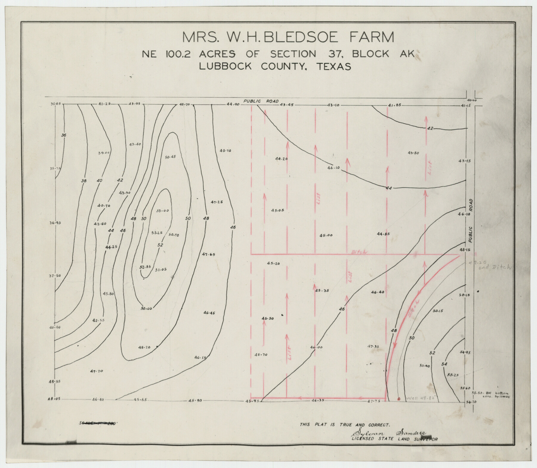
Mrs. W. H. Bledsoe Farm NE 100.2 Acres of Section 37, Block AK
-
Map/Doc
92283
-
Collection
Twichell Survey Records
-
People and Organizations
Sylvan Sanders (Surveyor/Engineer)
-
Counties
Lubbock
-
Height x Width
10.6 x 9.2 inches
26.9 x 23.4 cm
Part of: Twichell Survey Records
Map of State University Land, Pecos County, Texas

Print $20.00
- Digital $50.00
Map of State University Land, Pecos County, Texas
1929
Size 28.4 x 22.7 inches
Map/Doc 91631
[Sections Surrounding Sections 111, 90, 112, 89]
![92131, [Sections Surrounding Sections 111, 90, 112, 89], Twichell Survey Records](https://historictexasmaps.com/wmedia_w700/maps/92131-1.tif.jpg)
Print $20.00
- Digital $50.00
[Sections Surrounding Sections 111, 90, 112, 89]
Size 15.5 x 26.2 inches
Map/Doc 92131
Subdivision of Outlots 1 and 2 in Original Townsite of Seagraves, Texas

Print $20.00
- Digital $50.00
Subdivision of Outlots 1 and 2 in Original Townsite of Seagraves, Texas
1955
Size 17.3 x 29.1 inches
Map/Doc 92688
![90713, [Capitol Lands], Twichell Survey Records](https://historictexasmaps.com/wmedia_w700/maps/90713-1.tif.jpg)
Hill Ranch, Gaines County, Texas

Print $20.00
- Digital $50.00
Hill Ranch, Gaines County, Texas
1951
Size 21.2 x 16.6 inches
Map/Doc 92680
Ownership Map SE 1/4 Lubbock County

Print $20.00
- Digital $50.00
Ownership Map SE 1/4 Lubbock County
Size 37.2 x 36.4 inches
Map/Doc 89895
[Worksheets related to the Wilson Strickland survey and vicinity]
![91265, [Vicinity and related to the Wilson Strickland Survey], Twichell Survey Records](https://historictexasmaps.com/wmedia_w700/maps/91265-1.tif.jpg)
Print $20.00
- Digital $50.00
[Worksheets related to the Wilson Strickland survey and vicinity]
Size 39.0 x 11.6 inches
Map/Doc 91265
[Sketch showing A. B. & M. Block 2]
![91701, [Sketch showing A. B. & M. Block 2], Twichell Survey Records](https://historictexasmaps.com/wmedia_w700/maps/91701-1.tif.jpg)
Print $2.00
- Digital $50.00
[Sketch showing A. B. & M. Block 2]
Size 7.5 x 5.8 inches
Map/Doc 91701
[Plat showing connecting lines for the purpose of locating 4.3 acres in Caldwell County]
![90220, [Plat showing connecting lines for the purpose of locating 4.3 acres in Caldwell County], Twichell Survey Records](https://historictexasmaps.com/wmedia_w700/maps/90220-1.tif.jpg)
Print $2.00
- Digital $50.00
[Plat showing connecting lines for the purpose of locating 4.3 acres in Caldwell County]
1923
Size 7.4 x 10.2 inches
Map/Doc 90220
[Floyd County Schoo Land Lgs. 180-183, Fisher County School Land Lgs. 105-108, and part of Blk. V]
![90190, [Floyd County Schoo Land Lgs. 180-183, Fisher County School Land Lgs. 105-108, and part of Blk. V], Twichell Survey Records](https://historictexasmaps.com/wmedia_w700/maps/90190-1.tif.jpg)
Print $2.00
- Digital $50.00
[Floyd County Schoo Land Lgs. 180-183, Fisher County School Land Lgs. 105-108, and part of Blk. V]
Size 8.8 x 10.2 inches
Map/Doc 90190
[East Part of Block 37, Township 2 North]
![91395, [East Part of Block 37, Township 2 North], Twichell Survey Records](https://historictexasmaps.com/wmedia_w700/maps/91395-1.tif.jpg)
Print $3.00
- Digital $50.00
[East Part of Block 37, Township 2 North]
Size 9.6 x 17.6 inches
Map/Doc 91395
[Northwest Garza County around John Walker and Thomas Hughes surveys]
![90849, [Northwest Garza County around John Walker and Thomas Hughes surveys], Twichell Survey Records](https://historictexasmaps.com/wmedia_w700/maps/90849-2.tif.jpg)
Print $20.00
- Digital $50.00
[Northwest Garza County around John Walker and Thomas Hughes surveys]
1913
Size 27.5 x 14.5 inches
Map/Doc 90849
You may also like
Travis County Sketch File 6

Print $8.00
- Digital $50.00
Travis County Sketch File 6
1841
Size 13.8 x 10.9 inches
Map/Doc 38283
La Salle County Rolled Sketch 5

Print $20.00
- Digital $50.00
La Salle County Rolled Sketch 5
1937
Size 17.8 x 27.4 inches
Map/Doc 6570
Van Zandt County Working Sketch 2

Print $20.00
- Digital $50.00
Van Zandt County Working Sketch 2
1910
Size 17.8 x 11.6 inches
Map/Doc 72251
Wharton County Working Sketch 11

Print $20.00
- Digital $50.00
Wharton County Working Sketch 11
1976
Size 42.2 x 40.8 inches
Map/Doc 72475
Webb County Working Sketch 72

Print $20.00
- Digital $50.00
Webb County Working Sketch 72
1974
Size 22.1 x 38.2 inches
Map/Doc 72439
Flight Mission No. DCL-4C, Frame 96, Kenedy County

Print $20.00
- Digital $50.00
Flight Mission No. DCL-4C, Frame 96, Kenedy County
1943
Size 18.6 x 22.3 inches
Map/Doc 85817
Lampasas County Boundary File 10

Print $11.00
- Digital $50.00
Lampasas County Boundary File 10
Size 12.8 x 7.9 inches
Map/Doc 56184
Travis County Appraisal District Plat Map 2_1804

Print $20.00
- Digital $50.00
Travis County Appraisal District Plat Map 2_1804
Size 21.6 x 26.5 inches
Map/Doc 94203
[I. M. Bolton, L. S. Thacker, and R. C. Poteet Subdivisions]
![92577, [I. M. Bolton, L. S. Thacker, and R. C. Poteet Subdivisions], Twichell Survey Records](https://historictexasmaps.com/wmedia_w700/maps/92577-1.tif.jpg)
Print $20.00
- Digital $50.00
[I. M. Bolton, L. S. Thacker, and R. C. Poteet Subdivisions]
1924
Size 18.8 x 24.5 inches
Map/Doc 92577
Amerique Septentrionale divisée en ses principales parties

Print $20.00
- Digital $50.00
Amerique Septentrionale divisée en ses principales parties
1792
Size 21.3 x 25.9 inches
Map/Doc 93916
1883 Map of the Texas & Pacific R-Y Reserve

Print $40.00
- Digital $50.00
1883 Map of the Texas & Pacific R-Y Reserve
1883
Size 42.2 x 86.4 inches
Map/Doc 2236
[H. & G. N. RR. Company, Block 1 and Vicinity]
![91232, [H. & G. N. RR. Company, Block 1 and Vicinity], Twichell Survey Records](https://historictexasmaps.com/wmedia_w700/maps/91232-1.tif.jpg)
Print $20.00
- Digital $50.00
[H. & G. N. RR. Company, Block 1 and Vicinity]
Size 14.1 x 17.7 inches
Map/Doc 91232