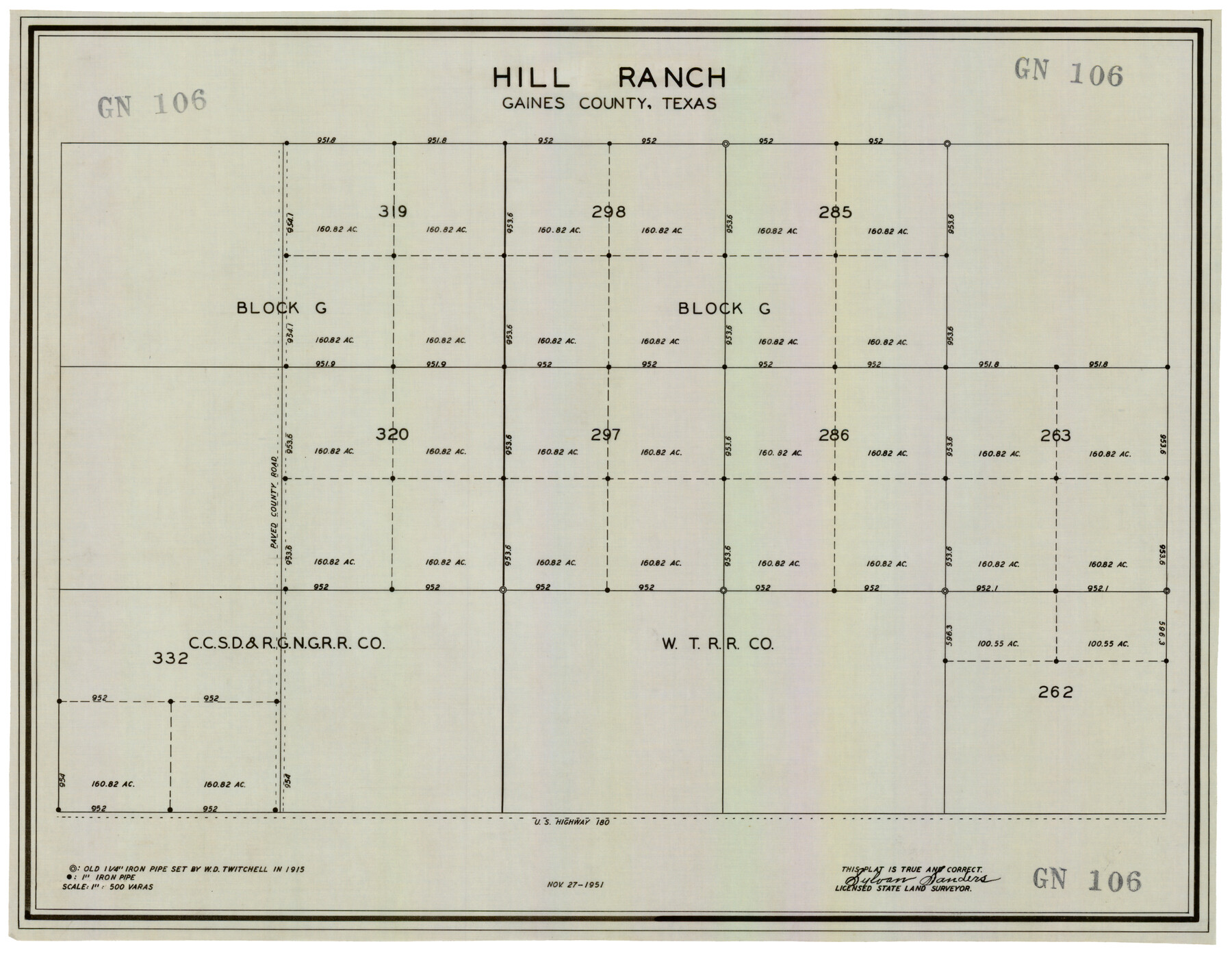
Hill Ranch, Gaines County, Texas
GN106
-
Map/Doc
92680
-
Collection
Twichell Survey Records
-
Object Dates
11/27/1951 (Creation Date)
-
People and Organizations
Sylvan Sanders (Surveyor/Engineer)
-
Counties
Gaines
-
Height x Width
21.2 x 16.6 inches
53.9 x 42.2 cm
Part of: Twichell Survey Records
[Capitol Lands in Lamb County]
![90996, [Capitol Lands in Lamb County], Twichell Survey Records](https://historictexasmaps.com/wmedia_w700/maps/90996-1.tif.jpg)
Print $20.00
- Digital $50.00
[Capitol Lands in Lamb County]
1903
Size 31.0 x 11.8 inches
Map/Doc 90996
Map of the Northwest Portion of Hutchinson County Showing the Proposed Resurvey of Block M24

Print $20.00
- Digital $50.00
Map of the Northwest Portion of Hutchinson County Showing the Proposed Resurvey of Block M24
Size 32.4 x 30.1 inches
Map/Doc 91237
Robertson & Scott V Ranch situated in Crosby County, Texas

Print $40.00
- Digital $50.00
Robertson & Scott V Ranch situated in Crosby County, Texas
Size 41.2 x 48.8 inches
Map/Doc 89758
Martin-Ameen Addition, City of Lubbock, South 100 Acres of Southeast Quarter, Section 5, Block E

Print $20.00
- Digital $50.00
Martin-Ameen Addition, City of Lubbock, South 100 Acres of Southeast Quarter, Section 5, Block E
Size 30.9 x 24.6 inches
Map/Doc 92737
[Sketch showing I. & G. N. Block 8]
![91715, [Sketch showing I. & G. N. Block 8], Twichell Survey Records](https://historictexasmaps.com/wmedia_w700/maps/91715-1.tif.jpg)
Print $2.00
- Digital $50.00
[Sketch showing I. & G. N. Block 8]
1919
Size 7.7 x 10.3 inches
Map/Doc 91715
[Sketch showing PSL Blocks A39, A40, A50-A57]
![89737, [Sketch showing PSL Blocks A39, A40, A50-A57], Twichell Survey Records](https://historictexasmaps.com/wmedia_w700/maps/89737-1.tif.jpg)
Print $40.00
- Digital $50.00
[Sketch showing PSL Blocks A39, A40, A50-A57]
Size 27.8 x 63.5 inches
Map/Doc 89737

[East Neches River]
![90420, [East Neches River], Twichell Survey Records](https://historictexasmaps.com/wmedia_w700/maps/90420-1.tif.jpg)
Print $20.00
- Digital $50.00
[East Neches River]
Size 25.8 x 29.3 inches
Map/Doc 90420
Revised Map of Pendleton-Baxter-Addition to Shamrock Located on N.E. 1/4 Section 37, Block 17 H. & G.N.RR.Co., Wheeler County, Texas

Print $20.00
- Digital $50.00
Revised Map of Pendleton-Baxter-Addition to Shamrock Located on N.E. 1/4 Section 37, Block 17 H. & G.N.RR.Co., Wheeler County, Texas
Size 16.7 x 18.8 inches
Map/Doc 92123
[H. & T. C. RR. Company, Block 47]
![91150, [H. & T. C. RR. Company, Block 47], Twichell Survey Records](https://historictexasmaps.com/wmedia_w700/maps/91150-1.tif.jpg)
Print $20.00
- Digital $50.00
[H. & T. C. RR. Company, Block 47]
1874
Size 20.4 x 12.5 inches
Map/Doc 91150
[Blocks D and DD, Yoakum County]
![92004, [Blocks D and DD, Yoakum County], Twichell Survey Records](https://historictexasmaps.com/wmedia_w700/maps/92004-1.tif.jpg)
Print $20.00
- Digital $50.00
[Blocks D and DD, Yoakum County]
Size 24.8 x 19.9 inches
Map/Doc 92004
[D. & S. E. Surs., G. C. & S. F. Blk. 9 west of University Land Blks. 49 and 50]
![90308, [D. & S. E. Surs., G. C. & S. F. Blk. 9 west of University Land Blks. 49 and 50], Twichell Survey Records](https://historictexasmaps.com/wmedia_w700/maps/90308-1.tif.jpg)
Print $3.00
- Digital $50.00
[D. & S. E. Surs., G. C. & S. F. Blk. 9 west of University Land Blks. 49 and 50]
Size 11.3 x 15.4 inches
Map/Doc 90308
You may also like

Stephens County Boundary File 4

Print $6.00
- Digital $50.00
Stephens County Boundary File 4
Size 14.3 x 8.8 inches
Map/Doc 58894
Gray County Boundary File 5

Print $6.00
- Digital $50.00
Gray County Boundary File 5
Size 11.9 x 9.4 inches
Map/Doc 53893
McLennan County Sketch File 7a

Print $4.00
- Digital $50.00
McLennan County Sketch File 7a
1850
Size 10.3 x 7.4 inches
Map/Doc 31246
Flight Mission No. DCL-6C, Frame 70, Kenedy County

Print $20.00
- Digital $50.00
Flight Mission No. DCL-6C, Frame 70, Kenedy County
1943
Size 18.6 x 22.3 inches
Map/Doc 85912
Right of Way & Track Map, St. Louis, Brownsville & Mexico Ry. operated by St. Louis, Brownsville & Mexico Ry. Co.

Print $40.00
- Digital $50.00
Right of Way & Track Map, St. Louis, Brownsville & Mexico Ry. operated by St. Louis, Brownsville & Mexico Ry. Co.
1919
Size 25.7 x 57.6 inches
Map/Doc 64619
Tahoka Consolidated Independent School District

Print $20.00
- Digital $50.00
Tahoka Consolidated Independent School District
Size 34.1 x 22.1 inches
Map/Doc 92943
Edwards County Working Sketch 4

Print $20.00
- Digital $50.00
Edwards County Working Sketch 4
Size 28.7 x 28.3 inches
Map/Doc 68880
Foard County Boundary File 6

Print $10.00
- Digital $50.00
Foard County Boundary File 6
Size 7.2 x 8.7 inches
Map/Doc 53548
Jefferson County Rolled Sketch 25

Print $20.00
- Digital $50.00
Jefferson County Rolled Sketch 25
1939
Size 43.4 x 36.0 inches
Map/Doc 9290
Montague County

Print $20.00
- Digital $50.00
Montague County
1924
Size 47.0 x 34.2 inches
Map/Doc 66938
Comal County Rolled Sketch 4

Print $20.00
- Digital $50.00
Comal County Rolled Sketch 4
1981
Size 18.8 x 24.5 inches
Map/Doc 5539