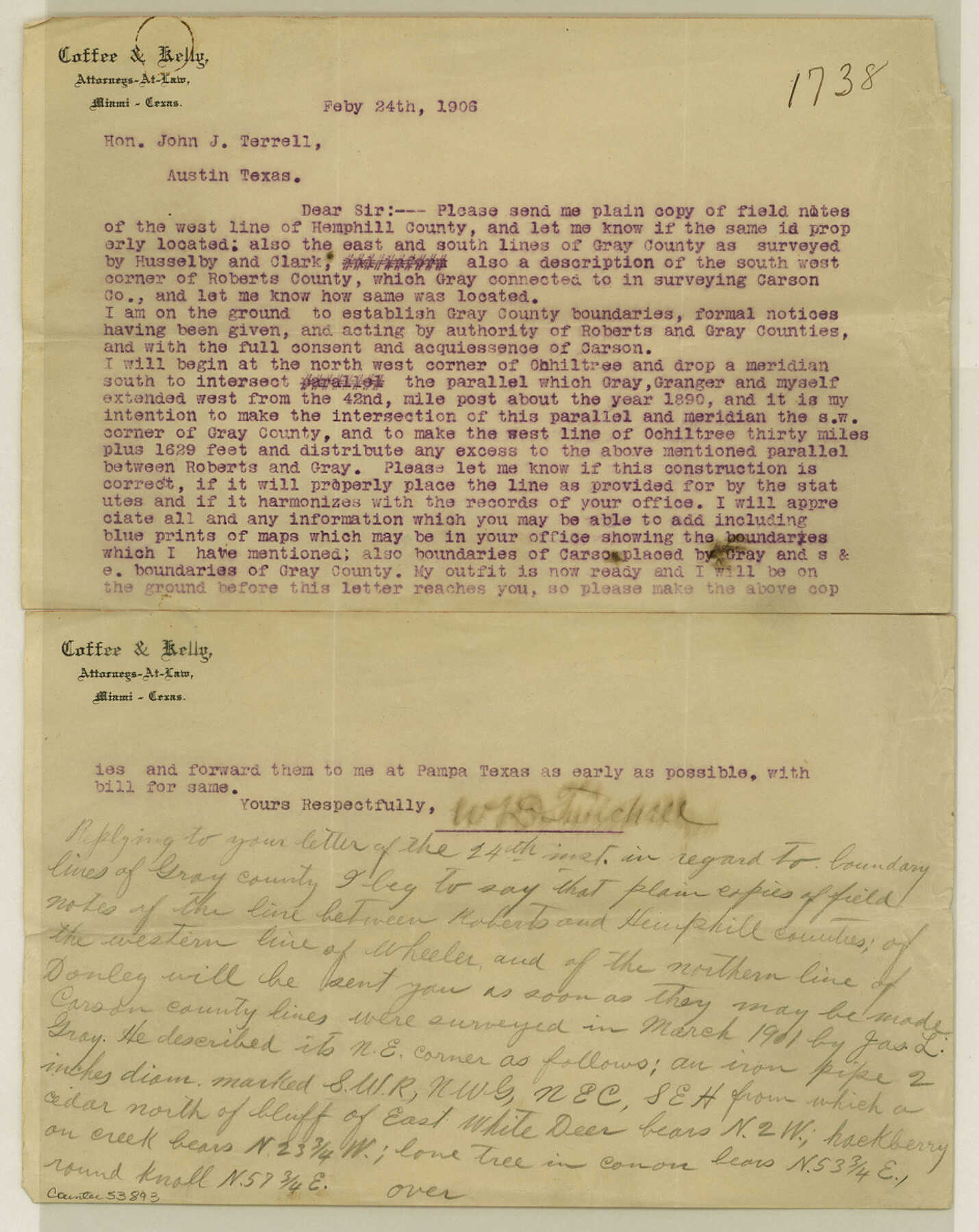
Gray County Boundary File 5
[Letter and Reply regarding Gray County Boundaries]
-
Map/Doc
53893
-
Collection
General Map Collection
-
Counties
Gray
-
Subjects
County Boundaries
-
Height x Width
11.9 x 9.4 inches
30.2 x 23.9 cm
Part of: General Map Collection
Map of Martin County

Print $20.00
- Digital $50.00
Map of Martin County
1900
Size 41.4 x 36.5 inches
Map/Doc 66918
Lamar County Sketch File 5

Print $4.00
- Digital $50.00
Lamar County Sketch File 5
1877
Size 4.8 x 8.1 inches
Map/Doc 29284
Roberts County Working Sketch 23

Print $20.00
- Digital $50.00
Roberts County Working Sketch 23
1979
Size 19.7 x 12.9 inches
Map/Doc 63549
Shelby County Rolled Sketch 6

Print $20.00
- Digital $50.00
Shelby County Rolled Sketch 6
Size 26.7 x 20.9 inches
Map/Doc 7776
Brewster County Working Sketch 55

Print $40.00
- Digital $50.00
Brewster County Working Sketch 55
1953
Size 51.1 x 27.5 inches
Map/Doc 67656
Milam County Rolled Sketch 2

Print $20.00
- Digital $50.00
Milam County Rolled Sketch 2
1954
Size 21.9 x 24.8 inches
Map/Doc 6774
Matagorda Bay and Approaches

Print $20.00
- Digital $50.00
Matagorda Bay and Approaches
1976
Size 35.8 x 45.2 inches
Map/Doc 73387

Pecos County Working Sketch 134

Print $40.00
- Digital $50.00
Pecos County Working Sketch 134
1979
Size 53.3 x 37.3 inches
Map/Doc 71608
Coryell County Working Sketch 20

Print $20.00
- Digital $50.00
Coryell County Working Sketch 20
1972
Size 32.2 x 22.4 inches
Map/Doc 68227
Galveston County NRC Article 33.136 Location Key Sheet

Print $20.00
- Digital $50.00
Galveston County NRC Article 33.136 Location Key Sheet
1994
Size 27.0 x 22.0 inches
Map/Doc 77015
Flight Mission No. CUG-1P, Frame 78, Kleberg County

Print $20.00
- Digital $50.00
Flight Mission No. CUG-1P, Frame 78, Kleberg County
1956
Size 18.9 x 22.5 inches
Map/Doc 86143
You may also like
Coryell County Working Sketch 1

Print $20.00
- Digital $50.00
Coryell County Working Sketch 1
1906
Size 14.7 x 12.9 inches
Map/Doc 68208
Dimmit County Working Sketch 13

Print $20.00
- Digital $50.00
Dimmit County Working Sketch 13
1941
Size 14.3 x 16.3 inches
Map/Doc 68674
McMullen County Sketch File 16

Print $24.00
- Digital $50.00
McMullen County Sketch File 16
1876
Size 5.3 x 8.3 inches
Map/Doc 31365
Right-of-way & Track Map Dawson Railway Operated by the El Paso & Southwestern Company Station 1655+23.4 to Station 1867+09.6

Print $40.00
- Digital $50.00
Right-of-way & Track Map Dawson Railway Operated by the El Paso & Southwestern Company Station 1655+23.4 to Station 1867+09.6
1910
Size 56.7 x 24.6 inches
Map/Doc 89657
Orange County Working Sketch 40

Print $20.00
- Digital $50.00
Orange County Working Sketch 40
1979
Size 19.2 x 12.1 inches
Map/Doc 71372
Jackson County Rolled Sketch 3C

Print $59.00
- Digital $50.00
Jackson County Rolled Sketch 3C
1913
Size 23.7 x 21.8 inches
Map/Doc 6339
[Blk. O1, W. H. Godair]
![90632, [Blk. O1, W. H. Godair], Twichell Survey Records](https://historictexasmaps.com/wmedia_w700/maps/90632-1.tif.jpg)
Print $20.00
- Digital $50.00
[Blk. O1, W. H. Godair]
1913
Size 30.1 x 10.3 inches
Map/Doc 90632
Anderson County Boundary File 5

Print $10.00
- Digital $50.00
Anderson County Boundary File 5
Size 8.1 x 7.2 inches
Map/Doc 49742
Edwards County Working Sketch 123

Print $20.00
- Digital $50.00
Edwards County Working Sketch 123
1976
Size 18.3 x 25.2 inches
Map/Doc 68999
Yoakum County Sketch File 10b

Print $20.00
- Digital $50.00
Yoakum County Sketch File 10b
Size 22.4 x 15.8 inches
Map/Doc 12707
Marion County Rolled Sketch 1

Print $20.00
- Digital $50.00
Marion County Rolled Sketch 1
1954
Size 21.5 x 23.5 inches
Map/Doc 6657
Sabine River, East Extension Merrill Lake Sheet

Print $4.00
- Digital $50.00
Sabine River, East Extension Merrill Lake Sheet
1933
Size 24.5 x 15.1 inches
Map/Doc 65141