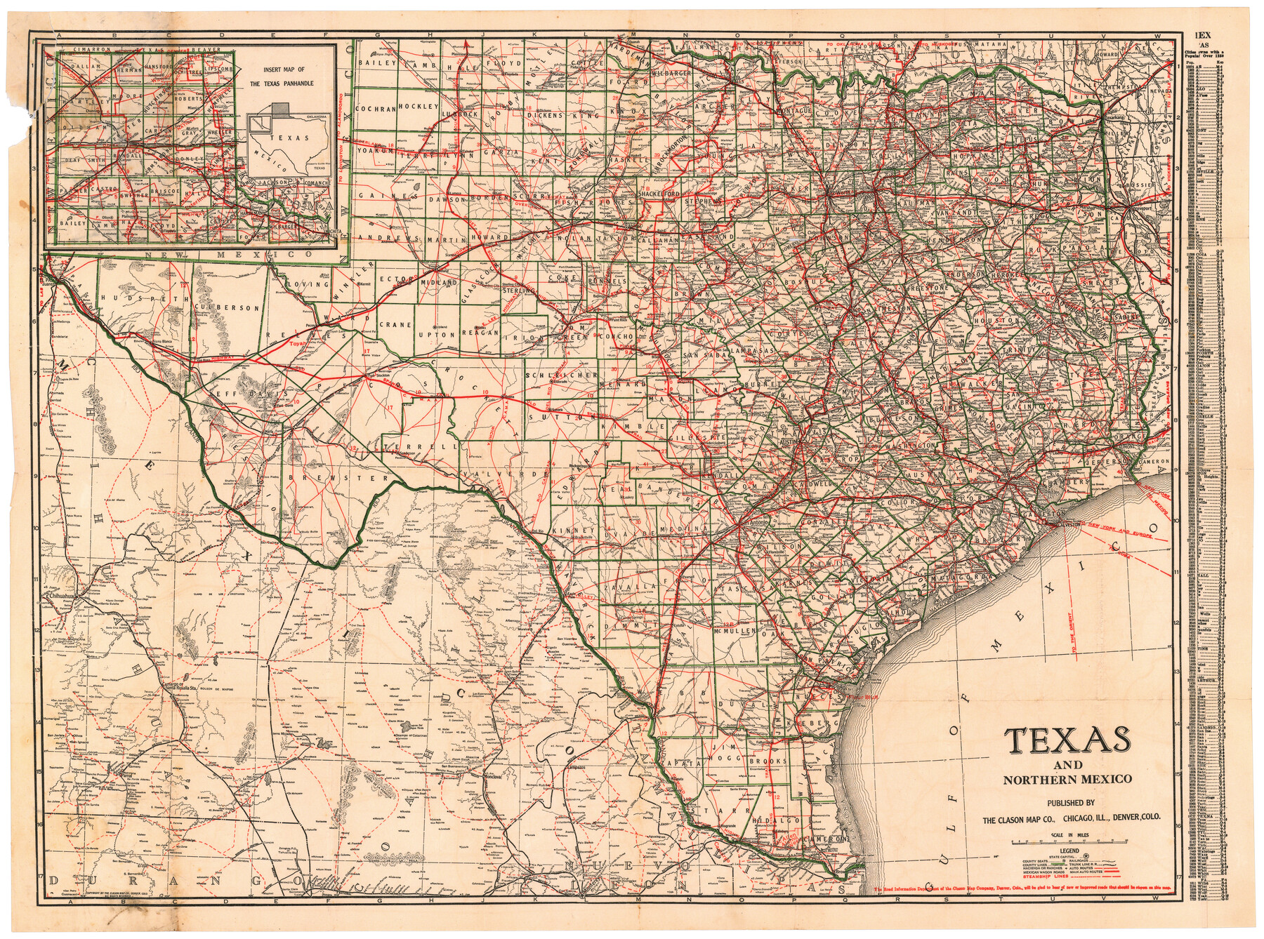
Texas and Northern Mexico
[Insert:] Insert Map of the Texas Panhandle
-
Map/Doc
95900
-
Collection
Cobb Digital Map Collection
-
Object Dates
[1925 ca.] (Creation Date)
-
People and Organizations
The Clason Map Co. (Publisher)
-
Subjects
Railroads State of Texas
-
Height x Width
21.0 x 28.3 inches
53.3 x 71.9 cm
-
Medium
digital image
-
Comments
Courtesy of John & Diana Cobb.
To view booklet in which this map was folded, click "Download PDF" link above.
Part of: Cobb Digital Map Collection
Map of Texas with population and location of principal towns and cities, according to latest reliable statistics

Print $20.00
- Digital $50.00
Map of Texas with population and location of principal towns and cities, according to latest reliable statistics
1906
Size 19.0 x 20.7 inches
Map/Doc 95867
The M. K. and T., Missouri, Kansas & Texas Ry.

Print $20.00
- Digital $50.00
The M. K. and T., Missouri, Kansas & Texas Ry.
1911
Size 15.9 x 9.1 inches
Map/Doc 95809

Red River County, Texas

Print $20.00
- Digital $50.00
Red River County, Texas
Size 22.2 x 17.2 inches
Map/Doc 95756
Map of the Missouri, Kansas & Texas Railway and its connecting lines

Print $20.00
- Digital $50.00
Map of the Missouri, Kansas & Texas Railway and its connecting lines
1901
Size 16.3 x 9.1 inches
Map/Doc 95810

San Antonio - Places of Interest and how to get there

San Antonio - Places of Interest and how to get there
1920
Map/Doc 96785
Map showing those portions of Texas traversed by the Rock Island System and connecting lines

Print $20.00
- Digital $50.00
Map showing those portions of Texas traversed by the Rock Island System and connecting lines
1903
Size 16.4 x 24.0 inches
Map/Doc 96587
Map of the Cincinnati, New Orleans and Texas Pacific Ry and connections

Print $20.00
- Digital $50.00
Map of the Cincinnati, New Orleans and Texas Pacific Ry and connections
1889
Size 7.7 x 12.2 inches
Map/Doc 95758
Phelps's National Map of the United States, a Travellers Guide. Embracing the principal railroads, canals, steamboat & stage routes, throughout the Union

Print $20.00
- Digital $50.00
Phelps's National Map of the United States, a Travellers Guide. Embracing the principal railroads, canals, steamboat & stage routes, throughout the Union
1849
Size 20.9 x 26.3 inches
Map/Doc 95901
"Iron Mountain Route" to all parts of Texas - I. & G. N., T. & P., Iron Mountain - "The Way to Texas"

Print $20.00
- Digital $50.00
"Iron Mountain Route" to all parts of Texas - I. & G. N., T. & P., Iron Mountain - "The Way to Texas"
1909
Size 21.8 x 24.0 inches
Map/Doc 95793
The Wonderful Lower Rio Grande Valley

Print $20.00
- Digital $50.00
The Wonderful Lower Rio Grande Valley
1909
Size 21.6 x 22.9 inches
Map/Doc 95798
You may also like
Sylvan Sanders Map of Gaines County, Texas

Print $40.00
- Digital $50.00
Sylvan Sanders Map of Gaines County, Texas
Size 54.3 x 40.8 inches
Map/Doc 89844
Hardin County Sketch File 57

Print $40.00
- Digital $50.00
Hardin County Sketch File 57
Size 15.4 x 14.1 inches
Map/Doc 25228
Cass County Working Sketch 15

Print $20.00
- Digital $50.00
Cass County Working Sketch 15
1957
Size 29.7 x 19.0 inches
Map/Doc 67918

Hutchinson County Rolled Sketch 43

Print $40.00
- Digital $50.00
Hutchinson County Rolled Sketch 43
1992
Size 38.0 x 49.4 inches
Map/Doc 6311
Jefferson Co.

Print $20.00
- Digital $50.00
Jefferson Co.
1918
Size 47.1 x 41.0 inches
Map/Doc 66884
Dimmit County Working Sketch 23

Print $20.00
- Digital $50.00
Dimmit County Working Sketch 23
1954
Size 22.5 x 23.3 inches
Map/Doc 68684
Flight Mission No. DQN-1K, Frame 139, Calhoun County

Print $20.00
- Digital $50.00
Flight Mission No. DQN-1K, Frame 139, Calhoun County
1953
Size 18.4 x 22.3 inches
Map/Doc 84202
General Highway Map. Detail of Cities and Towns in Waller County, Texas [Hempstead and vicinity]
![79701, General Highway Map. Detail of Cities and Towns in Waller County, Texas [Hempstead and vicinity], Texas State Library and Archives](https://historictexasmaps.com/wmedia_w700/maps/79701.tif.jpg)
Print $20.00
General Highway Map. Detail of Cities and Towns in Waller County, Texas [Hempstead and vicinity]
1961
Size 24.8 x 18.2 inches
Map/Doc 79701
Wharton County Rolled Sketch 8

Print $20.00
- Digital $50.00
Wharton County Rolled Sketch 8
Size 24.4 x 39.2 inches
Map/Doc 8232
Hemphill County Working Sketch 2

Print $20.00
- Digital $50.00
Hemphill County Working Sketch 2
1926
Size 29.0 x 31.1 inches
Map/Doc 66097
Angelina County Sketch File 18c

Print $4.00
- Digital $50.00
Angelina County Sketch File 18c
Size 12.8 x 8.3 inches
Map/Doc 13034