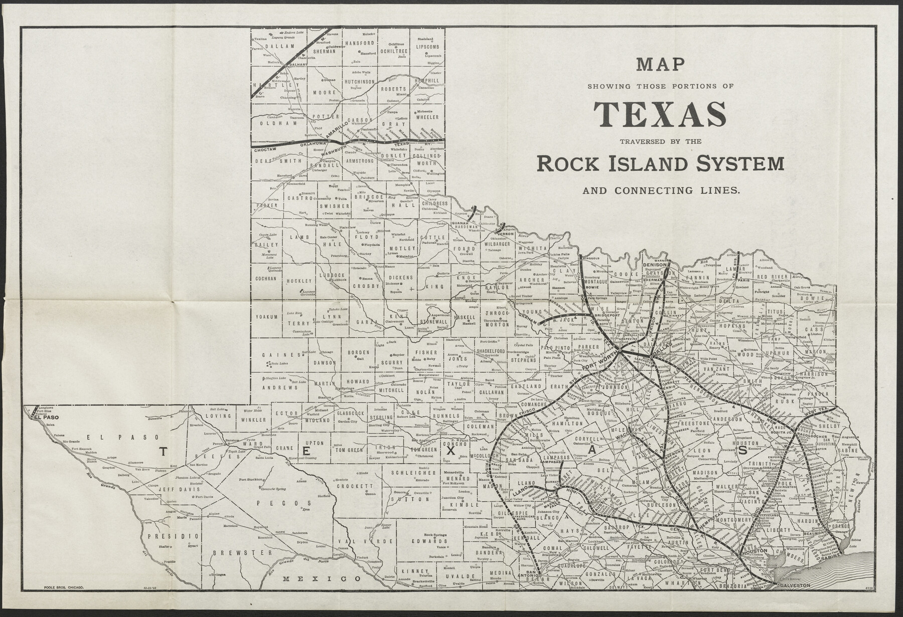
Map showing those portions of Texas traversed by the Rock Island System and connecting lines
-
Map/Doc
96587
-
Collection
Cobb Digital Map Collection
-
Object Dates
12/22/1903 (Creation Date)
-
People and Organizations
Poole Bros. (Publisher)
-
Subjects
Railroads State of Texas
-
Height x Width
16.4 x 24.0 inches
41.7 x 61.0 cm
-
Medium
digital image
-
Comments
Courtesy of John & Diana Cobb.
To view the original booklet, "Texas, a World of Plenty", in which this map was contained, click the "Download PDF" link above.
Part of: Cobb Digital Map Collection
Correct Map of the Missouri, Kansas & Texas Railway and connections

Print $20.00
- Digital $50.00
Correct Map of the Missouri, Kansas & Texas Railway and connections
1895
Size 17.9 x 39.8 inches
Map/Doc 95808
A Geographically Correct County Map of States Traversed by the St. Louis, Iron Mountain and Southern Railway and its connections

Print $20.00
- Digital $50.00
A Geographically Correct County Map of States Traversed by the St. Louis, Iron Mountain and Southern Railway and its connections
1878
Size 16.9 x 27.0 inches
Map/Doc 95785
Health Wealth and Happiness in the Texas Panhandle

Health Wealth and Happiness in the Texas Panhandle
1906
Map/Doc 96753
[Map of Texas showing Frisco Lines]
![95796, [Map of Texas showing Frisco Lines], Cobb Digital Map Collection](https://historictexasmaps.com/wmedia_w700/maps/95796.tif.jpg)
Print $20.00
- Digital $50.00
[Map of Texas showing Frisco Lines]
1910
Size 19.8 x 19.2 inches
Map/Doc 95796
New Birmingham, Cherokee County, Texas

Print $20.00
- Digital $50.00
New Birmingham, Cherokee County, Texas
1891
Size 23.1 x 19.2 inches
Map/Doc 96617

Santa Rosa, the Saint of Roses - Lower Rio Grande Valley

Santa Rosa, the Saint of Roses - Lower Rio Grande Valley
1920
Map/Doc 96734
Corpus Christi, Where Texas Meets the Sea

Corpus Christi, Where Texas Meets the Sea
1928
Size 9.7 x 6.9 inches
Map/Doc 97065
Sectional map of Texas traversed by the Missouri, Kansas & Texas Railway, showing the crops adapted to each section, with the elevation and annual rainfall

Print $20.00
- Digital $50.00
Sectional map of Texas traversed by the Missouri, Kansas & Texas Railway, showing the crops adapted to each section, with the elevation and annual rainfall
1904
Size 21.7 x 22.6 inches
Map/Doc 95814
Map of Texas with population and location of principal towns and cities according to latest reliable statistics

Print $20.00
- Digital $50.00
Map of Texas with population and location of principal towns and cities according to latest reliable statistics
1912
Size 18.0 x 20.2 inches
Map/Doc 95876
Shallow Water Country of Northwest Texas

Shallow Water Country of Northwest Texas
1916
Map/Doc 96758
The Texas and Oklahoma Official Railway & Hotel Guide Map

Print $20.00
- Digital $50.00
The Texas and Oklahoma Official Railway & Hotel Guide Map
1906
Size 23.4 x 23.7 inches
Map/Doc 95892
You may also like
Lamb-Castro County Line

Print $20.00
- Digital $50.00
Lamb-Castro County Line
Size 45.3 x 15.5 inches
Map/Doc 91057
Panola County, Texas

Print $20.00
- Digital $50.00
Panola County, Texas
1879
Size 18.0 x 19.4 inches
Map/Doc 654
The Mexican Department of Bexar. January 31, 1831

Print $20.00
The Mexican Department of Bexar. January 31, 1831
2020
Size 16.1 x 21.7 inches
Map/Doc 95968
Grimes County

Print $40.00
- Digital $50.00
Grimes County
1922
Size 55.7 x 28.2 inches
Map/Doc 77296
Kimble County Working Sketch 67

Print $20.00
- Digital $50.00
Kimble County Working Sketch 67
1965
Size 20.7 x 34.5 inches
Map/Doc 70135
Nueces County Sketch File 1

Print $24.00
- Digital $50.00
Nueces County Sketch File 1
1847
Size 7.6 x 12.5 inches
Map/Doc 32497
Kleberg County Rolled Sketch 10-13

Print $20.00
- Digital $50.00
Kleberg County Rolled Sketch 10-13
1952
Size 37.0 x 32.5 inches
Map/Doc 9391
San Jacinto County Rolled Sketch 10B

Print $40.00
- Digital $50.00
San Jacinto County Rolled Sketch 10B
1944
Size 76.5 x 43.2 inches
Map/Doc 9883
Scurry County

Print $20.00
- Digital $50.00
Scurry County
1921
Size 42.4 x 39.1 inches
Map/Doc 95637
Ward County, 1902

Print $40.00
- Digital $50.00
Ward County, 1902
1902
Size 51.8 x 31.3 inches
Map/Doc 89650
Ward County Working Sketch Graphic Index - sheet B

Print $40.00
- Digital $50.00
Ward County Working Sketch Graphic Index - sheet B
1932
Size 30.5 x 52.5 inches
Map/Doc 76732
Anderson County Rolled Sketch 15

Print $20.00
- Digital $50.00
Anderson County Rolled Sketch 15
2002
Size 40.0 x 28.3 inches
Map/Doc 78315