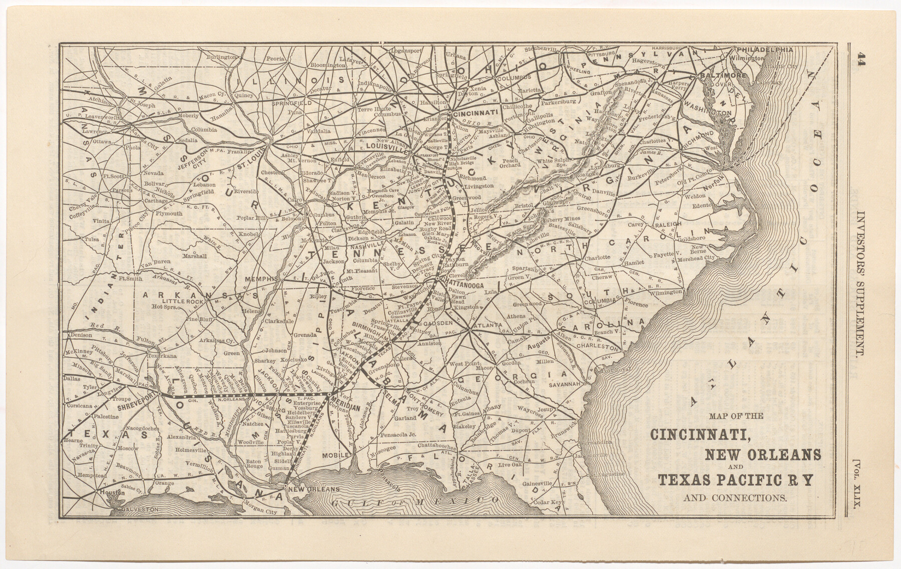
Map of the Cincinnati, New Orleans and Texas Pacific Ry and connections
-
Map/Doc
95758
-
Collection
Cobb Digital Map Collection
-
Object Dates
[1889] (Creation Date)
-
Subjects
Railroads Texas and Pacific Railroad
-
Height x Width
7.7 x 12.2 inches
19.6 x 31.0 cm
-
Medium
digital image
-
Comments
Courtesy of John & Diana Cobb.
To view information located on verso, click "Download PDF" link above.
Part of: Cobb Digital Map Collection
A Little Journey through the Lower Valley of the Rio Grande - The Magic Valley of Texas

A Little Journey through the Lower Valley of the Rio Grande - The Magic Valley of Texas
1929
Map/Doc 96742
Southern Homes in Southern Texas, The Celebrated Coast Country

Southern Homes in Southern Texas, The Celebrated Coast Country
1899
Size 6.2 x 3.7 inches
Map/Doc 97050

Profitable Products of East Texas, Orchards and Gardens

Profitable Products of East Texas, Orchards and Gardens
1910
Map/Doc 96775

Sunny San Antonio - The Winter Playground of America

Sunny San Antonio - The Winter Playground of America
1920
Size 9.4 x 7.9 inches
Map/Doc 97040
I. & G. N. - International and Great Northern R.R. - International Route - Galveston, Ft. Worth, Waco, Houston, Austin, Laredo, San Antonio

Print $20.00
- Digital $50.00
I. & G. N. - International and Great Northern R.R. - International Route - Galveston, Ft. Worth, Waco, Houston, Austin, Laredo, San Antonio
1910
Size 24.0 x 16.2 inches
Map/Doc 95779
Plat showing Gulf Coast Irrigation Company's lands at Raymondville, Lyford and Sebastian, Texas.

Print $20.00
- Digital $50.00
Plat showing Gulf Coast Irrigation Company's lands at Raymondville, Lyford and Sebastian, Texas.
1910
Size 13.9 x 16.9 inches
Map/Doc 95797
The Beautiful Valley of the Lower Rio Grande

The Beautiful Valley of the Lower Rio Grande
1925
Map/Doc 96735
Sectional map of Texas traversed by the Missouri, Kansas & Texas Railway, showing the crops adapted to each section, with the elevation and annual rainfall

Print $20.00
- Digital $50.00
Sectional map of Texas traversed by the Missouri, Kansas & Texas Railway, showing the crops adapted to each section, with the elevation and annual rainfall
1908
Size 21.8 x 22.8 inches
Map/Doc 95817
Southern Pacific Railway and Steamship Lines

Print $20.00
- Digital $50.00
Southern Pacific Railway and Steamship Lines
1900
Size 23.8 x 35.5 inches
Map/Doc 96586

You may also like
Preliminary Sketch of Galveston Bay, Texas

Print $20.00
Preliminary Sketch of Galveston Bay, Texas
1852
Size 22.6 x 18.3 inches
Map/Doc 79317
Coast Chart No. 210 Aransas Pass and Corpus Christi Bay with the coast to latitude 27° 12' Texas

Print $20.00
- Digital $50.00
Coast Chart No. 210 Aransas Pass and Corpus Christi Bay with the coast to latitude 27° 12' Texas
1887
Size 27.1 x 18.3 inches
Map/Doc 72804

Hood County Rolled Sketch 5

Print $20.00
- Digital $50.00
Hood County Rolled Sketch 5
1980
Size 29.9 x 32.2 inches
Map/Doc 6221

Val Verde County Working Sketch 22

Print $20.00
- Digital $50.00
Val Verde County Working Sketch 22
1931
Size 27.6 x 33.0 inches
Map/Doc 72157
Harris County Sketch File 75

Print $4.00
- Digital $50.00
Harris County Sketch File 75
1948
Size 11.7 x 9.0 inches
Map/Doc 25544
Flight Mission No. CRC-4R, Frame 177, Chambers County

Print $20.00
- Digital $50.00
Flight Mission No. CRC-4R, Frame 177, Chambers County
1956
Size 18.7 x 22.3 inches
Map/Doc 84928
Map of Freestone County

Print $20.00
- Digital $50.00
Map of Freestone County
1874
Size 21.8 x 24.5 inches
Map/Doc 3563
[Blocks G and H, and vicinity]
![92671, [Blocks G and H, and vicinity], Twichell Survey Records](https://historictexasmaps.com/wmedia_w700/maps/92671-1.tif.jpg)
Print $20.00
- Digital $50.00
[Blocks G and H, and vicinity]
1915
Size 18.4 x 12.4 inches
Map/Doc 92671
Jefferson County Sketch File 7

Print $8.00
- Digital $50.00
Jefferson County Sketch File 7
Size 10.3 x 8.1 inches
Map/Doc 28112
Angelina County Sketch File 13

Print $4.00
- Digital $50.00
Angelina County Sketch File 13
1860
Size 13.0 x 8.2 inches
Map/Doc 12957