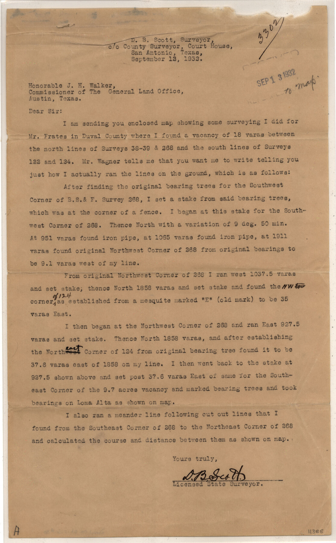
Duval County Sketch File 30
[Statement regarding vacancy between B. S. & F. sections]
-
Map/Doc
11388
-
Collection
General Map Collection
-
Object Dates
1932/9/12 (Creation Date)
1932/9/13 (File Date)
1932/9/8 (Survey Date)
-
People and Organizations
D.B. Scott (Surveyor/Engineer)
-
Counties
Duval
-
Subjects
Surveying Sketch File
-
Height x Width
14.7 x 23.7 inches
37.3 x 60.2 cm
-
Medium
multi-page, multi-format
-
Scale
1:500
Part of: General Map Collection
Refugio County Sketch File 16

Print $4.00
- Digital $50.00
Refugio County Sketch File 16
Size 7.1 x 8.2 inches
Map/Doc 35270
Val Verde County Working Sketch 84

Print $20.00
- Digital $50.00
Val Verde County Working Sketch 84
1973
Size 45.4 x 33.0 inches
Map/Doc 72219
Victoria County Rolled Sketch 1

Print $20.00
- Digital $50.00
Victoria County Rolled Sketch 1
1902
Size 20.5 x 17.5 inches
Map/Doc 8150
Eastland County Working Sketch 58

Print $20.00
- Digital $50.00
Eastland County Working Sketch 58
1985
Size 25.5 x 39.6 inches
Map/Doc 68839
Galveston County NRC Article 33.136 Sketch 60

Print $88.00
- Digital $50.00
Galveston County NRC Article 33.136 Sketch 60
2009
Size 24.0 x 36.0 inches
Map/Doc 89263
Collingsworth County Rolled Sketch 3

Print $40.00
- Digital $50.00
Collingsworth County Rolled Sketch 3
1941
Size 55.7 x 23.2 inches
Map/Doc 8639

Stephens County Sketch File 12

Print $8.00
- Digital $50.00
Stephens County Sketch File 12
1884
Size 10.8 x 8.3 inches
Map/Doc 37057
Hood County Sketch File 9

Print $26.00
- Digital $50.00
Hood County Sketch File 9
1859
Size 9.6 x 4.5 inches
Map/Doc 26586
Calcasieu Pass to Sabine Pass

Print $20.00
- Digital $50.00
Calcasieu Pass to Sabine Pass
1925
Size 44.1 x 36.0 inches
Map/Doc 69804

Angelina County Sketch File 18c

Print $4.00
- Digital $50.00
Angelina County Sketch File 18c
Size 12.8 x 8.3 inches
Map/Doc 13034
You may also like
Throckmorton County Sketch File 11

Print $30.00
- Digital $50.00
Throckmorton County Sketch File 11
1884
Size 8.9 x 11.6 inches
Map/Doc 38105

Flight Mission No. CRC-2R, Frame 188, Chambers County

Print $20.00
- Digital $50.00
Flight Mission No. CRC-2R, Frame 188, Chambers County
1956
Size 18.5 x 22.3 inches
Map/Doc 84766
Wilson County Working Sketch 10

Print $20.00
- Digital $50.00
Wilson County Working Sketch 10
1980
Size 16.6 x 11.7 inches
Map/Doc 72590
Reconnaissance of the Coast of Texas between Matagorda and Corpus Christi Bays

Print $20.00
- Digital $50.00
Reconnaissance of the Coast of Texas between Matagorda and Corpus Christi Bays
1858
Size 25.2 x 21.4 inches
Map/Doc 75987
Map of Asylum Lands

Print $20.00
- Digital $50.00
Map of Asylum Lands
1857
Size 28.4 x 18.5 inches
Map/Doc 2459
Matagorda County Working Sketch 30

Print $20.00
- Digital $50.00
Matagorda County Working Sketch 30
1981
Size 21.0 x 19.7 inches
Map/Doc 70888
Maverick County Sketch File 24

Print $36.00
- Digital $50.00
Maverick County Sketch File 24
1890
Size 9.1 x 8.7 inches
Map/Doc 31145
Coleman County Working Sketch 17

Print $20.00
- Digital $50.00
Coleman County Working Sketch 17
1952
Size 24.8 x 29.2 inches
Map/Doc 68083
San Jacinto County Boundary File 1a

Print $58.00
- Digital $50.00
San Jacinto County Boundary File 1a
Size 14.5 x 8.9 inches
Map/Doc 58551
Bandera County Boundary File 2

Print $4.00
- Digital $50.00
Bandera County Boundary File 2
Size 9.1 x 7.5 inches
Map/Doc 50264
Map of North America to illustrate Olney's school geography

Print $20.00
- Digital $50.00
Map of North America to illustrate Olney's school geography
1844
Size 12.1 x 9.3 inches
Map/Doc 93536