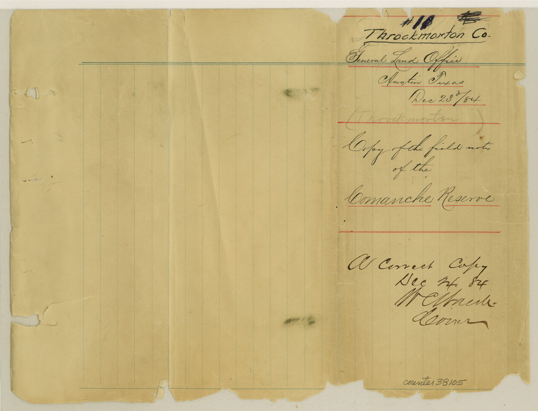
Throckmorton County Sketch File 11
[Copy of the field notes of the Comanche Reserve]
-
Map/Doc
38105
-
Collection
General Map Collection
-
Object Dates
1884/3/22 (Creation Date)
1884/12/23 (File Date)
1884/3/22 (Correspondence Date)
1854/9/30 (Survey Date)
1853/8/16 (Survey Date)
-
People and Organizations
Captain R.B. Marcy (Surveyor/Engineer)
Hiram Price (Commissioner)
Robert S. Neighbors (Agent)
Neil McLennan (Surveyor/Engineer)
-
Counties
Throckmorton
-
Subjects
Surveying Sketch File
-
Height x Width
8.9 x 11.6 inches
22.6 x 29.5 cm
-
Medium
paper, manuscript
-
Features
Comanche Reserve
Clear Fork of Brazos River
Road from Fort Belknap to Fort Phantom Hill
Paint Creek
Sibley's Creek
Part of: General Map Collection
McCulloch County Boundary File 1

Print $40.00
- Digital $50.00
McCulloch County Boundary File 1
Size 9.2 x 33.6 inches
Map/Doc 56906
El Paso County

Print $40.00
- Digital $50.00
El Paso County
1881
Size 52.0 x 36.8 inches
Map/Doc 89059
Flight Mission No. CRE-3R, Frame 40, Jackson County

Print $20.00
- Digital $50.00
Flight Mission No. CRE-3R, Frame 40, Jackson County
1956
Size 18.6 x 22.3 inches
Map/Doc 85387
Tarrant's Key and Guide to Dallas

Print $3.00
- Digital $50.00
Tarrant's Key and Guide to Dallas
1922
Size 7.9 x 10.4 inches
Map/Doc 89257
Flight Mission No. BRA-6M, Frame 90, Jefferson County

Print $20.00
- Digital $50.00
Flight Mission No. BRA-6M, Frame 90, Jefferson County
1953
Size 18.5 x 22.2 inches
Map/Doc 85433
Matagorda Light to Aransas Pass

Print $20.00
- Digital $50.00
Matagorda Light to Aransas Pass
1946
Size 35.8 x 44.5 inches
Map/Doc 73394
McLennan County Sketch File 25

Print $2.00
- Digital $50.00
McLennan County Sketch File 25
Size 8.8 x 12.3 inches
Map/Doc 31299
Flight Mission No. BRA-16M, Frame 69, Jefferson County

Print $20.00
- Digital $50.00
Flight Mission No. BRA-16M, Frame 69, Jefferson County
1953
Size 18.6 x 22.2 inches
Map/Doc 85686
Outer Continental Shelf Leasing Maps (Louisiana Offshore Operations)

Print $20.00
- Digital $50.00
Outer Continental Shelf Leasing Maps (Louisiana Offshore Operations)
1955
Size 11.1 x 13.3 inches
Map/Doc 76090
Cass County Texas

Print $20.00
- Digital $50.00
Cass County Texas
1879
Size 17.7 x 21.3 inches
Map/Doc 4516
Map of Winkler County

Print $20.00
- Digital $50.00
Map of Winkler County
1901
Size 43.1 x 36.6 inches
Map/Doc 4158
Cherokee County Sketch File 37

Print $40.00
- Digital $50.00
Cherokee County Sketch File 37
1978
Size 11.2 x 8.7 inches
Map/Doc 18225
You may also like
Rockwall County Boundary File 2

Print $12.00
- Digital $50.00
Rockwall County Boundary File 2
Size 14.4 x 8.9 inches
Map/Doc 58385
Red River County

Print $20.00
- Digital $50.00
Red River County
1934
Size 46.0 x 39.2 inches
Map/Doc 73272
Railroad Track Map, H&TCRRCo., Falls County, Texas

Print $4.00
- Digital $50.00
Railroad Track Map, H&TCRRCo., Falls County, Texas
1918
Size 11.7 x 18.5 inches
Map/Doc 62858
Concho County Boundary File 2

Print $30.00
- Digital $50.00
Concho County Boundary File 2
Size 12.7 x 8.3 inches
Map/Doc 51814
Reagan County Sketch File 11

Print $20.00
- Digital $50.00
Reagan County Sketch File 11
1928
Size 26.7 x 22.2 inches
Map/Doc 12217
Atascosa County Sketch File 37

Print $40.00
- Digital $50.00
Atascosa County Sketch File 37
Size 17.6 x 12.9 inches
Map/Doc 13829
Andrews County Rolled Sketch 15

Print $20.00
- Digital $50.00
Andrews County Rolled Sketch 15
1934
Size 27.9 x 22.4 inches
Map/Doc 77166
Flight Mission No. DQO-8K, Frame 89, Galveston County

Print $20.00
- Digital $50.00
Flight Mission No. DQO-8K, Frame 89, Galveston County
1952
Size 18.6 x 22.4 inches
Map/Doc 85191
[Worksheets related to the Wilson Strickland survey and vicinity]
![91267, [Vicinity and related to the Wilson Strickland Survey], Twichell Survey Records](https://historictexasmaps.com/wmedia_w700/maps/91267-1.tif.jpg)
Print $20.00
- Digital $50.00
[Worksheets related to the Wilson Strickland survey and vicinity]
Size 21.7 x 19.4 inches
Map/Doc 91267
Hudspeth County Sketch File 53

Print $6.00
- Digital $50.00
Hudspeth County Sketch File 53
1993
Size 14.3 x 8.9 inches
Map/Doc 27076
Map of the Mexican National R.R. "Laredo Route" and Connections. The Scenic Short Line to the City of Mexico

Print $20.00
- Digital $50.00
Map of the Mexican National R.R. "Laredo Route" and Connections. The Scenic Short Line to the City of Mexico
1901
Size 24.2 x 24.3 inches
Map/Doc 95145
Jeff Davis County Working Sketch 42

Print $20.00
- Digital $50.00
Jeff Davis County Working Sketch 42
1983
Size 42.7 x 46.7 inches
Map/Doc 66537