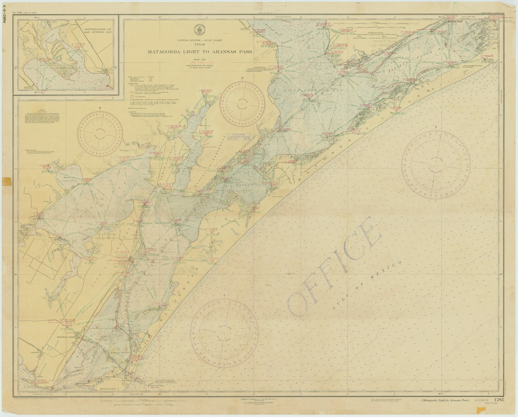
Matagorda Light to Aransas Pass
K-6-1285a
-
Map/Doc
73394
-
Collection
General Map Collection
-
Object Dates
1946/4/20 (Creation Date)
-
Counties
Refugio San Patricio Aransas
-
Subjects
Nautical Charts
-
Height x Width
35.8 x 44.5 inches
90.9 x 113.0 cm
Part of: General Map Collection
Mason County Boundary File 5a

Print $40.00
- Digital $50.00
Mason County Boundary File 5a
Size 18.0 x 32.6 inches
Map/Doc 56872
Flight Mission No. DQO-14T, Frame 65, Galveston County

Print $20.00
- Digital $50.00
Flight Mission No. DQO-14T, Frame 65, Galveston County
1958
Size 17.6 x 17.4 inches
Map/Doc 85216
Val Verde County Sketch File 31

Print $18.00
- Digital $50.00
Val Verde County Sketch File 31
1922
Size 11.2 x 9.0 inches
Map/Doc 39240
Flight Mission No. BRA-7M, Frame 73, Jefferson County

Print $20.00
- Digital $50.00
Flight Mission No. BRA-7M, Frame 73, Jefferson County
1953
Size 18.7 x 22.4 inches
Map/Doc 85495
[Jack District Map]
![1991, [Jack District Map], General Map Collection](https://historictexasmaps.com/wmedia_w700/maps/1991.tif.jpg)
Print $20.00
- Digital $50.00
[Jack District Map]
1877
Size 46.4 x 35.8 inches
Map/Doc 1991
Bexar County Sketch File 27

Print $4.00
- Digital $50.00
Bexar County Sketch File 27
1860
Size 8.6 x 6.5 inches
Map/Doc 14490
Upton County Working Sketch 10

Print $20.00
- Digital $50.00
Upton County Working Sketch 10
1926
Size 28.1 x 30.6 inches
Map/Doc 69506
Hutchinson County Working Sketch 49

Print $20.00
- Digital $50.00
Hutchinson County Working Sketch 49
1988
Size 35.2 x 37.3 inches
Map/Doc 66409
Aransas County Rolled Sketch 27C

Print $20.00
- Digital $50.00
Aransas County Rolled Sketch 27C
1979
Size 17.3 x 19.3 inches
Map/Doc 5056
Webb County Rolled Sketch EF2

Print $20.00
- Digital $50.00
Webb County Rolled Sketch EF2
1932
Size 40.4 x 29.9 inches
Map/Doc 8224
Oldham County

Print $40.00
- Digital $50.00
Oldham County
1925
Size 42.6 x 51.5 inches
Map/Doc 77387
Henderson County Working Sketch 12

Print $20.00
- Digital $50.00
Henderson County Working Sketch 12
1915
Size 23.3 x 24.9 inches
Map/Doc 66145
You may also like
[Leagues 11 and 22]
![91111, [Leagues 11 and 22], Twichell Survey Records](https://historictexasmaps.com/wmedia_w700/maps/91111-1.tif.jpg)
Print $20.00
- Digital $50.00
[Leagues 11 and 22]
1925
Size 14.0 x 13.6 inches
Map/Doc 91111
[Surveys along Seco Creek]
![268, [Surveys along Seco Creek], General Map Collection](https://historictexasmaps.com/wmedia_w700/maps/268.tif.jpg)
Print $3.00
- Digital $50.00
[Surveys along Seco Creek]
1847
Size 14.6 x 9.8 inches
Map/Doc 268
Hood County Sketch File 27

Print $4.00
- Digital $50.00
Hood County Sketch File 27
1873
Size 12.9 x 8.5 inches
Map/Doc 26629
Denton County Boundary File 4 and 4a and 4b and 4c

Print $2.00
- Digital $50.00
Denton County Boundary File 4 and 4a and 4b and 4c
Size 11.0 x 8.7 inches
Map/Doc 52470
Colorado County Working Sketch 10

Print $20.00
- Digital $50.00
Colorado County Working Sketch 10
1940
Size 23.2 x 24.4 inches
Map/Doc 68110
Texas-Louisiana Gulf Coastal Region showing Oil & Gas Fields & Prospects, Pipe Lines, Refineries & Principal Highways

Print $20.00
- Digital $50.00
Texas-Louisiana Gulf Coastal Region showing Oil & Gas Fields & Prospects, Pipe Lines, Refineries & Principal Highways
1933
Size 22.4 x 44.2 inches
Map/Doc 96874
Limestone County Sketch File 18

Print $6.00
- Digital $50.00
Limestone County Sketch File 18
Size 16.0 x 10.7 inches
Map/Doc 30191
Cass County Sketch File 1

Print $4.00
- Digital $50.00
Cass County Sketch File 1
1857
Size 11.6 x 8.2 inches
Map/Doc 17392
Smith County Working Sketch 11

Print $20.00
- Digital $50.00
Smith County Working Sketch 11
1960
Size 18.6 x 21.6 inches
Map/Doc 63896
Brazoria County Rolled Sketch 46

Print $40.00
- Digital $50.00
Brazoria County Rolled Sketch 46
1950
Size 30.7 x 57.3 inches
Map/Doc 8462
Presidio County Rolled Sketch 95

Print $20.00
- Digital $50.00
Presidio County Rolled Sketch 95
1949
Size 45.4 x 37.5 inches
Map/Doc 9781
Map of Anderson County

Print $20.00
- Digital $50.00
Map of Anderson County
1879
Size 18.9 x 23.5 inches
Map/Doc 3229