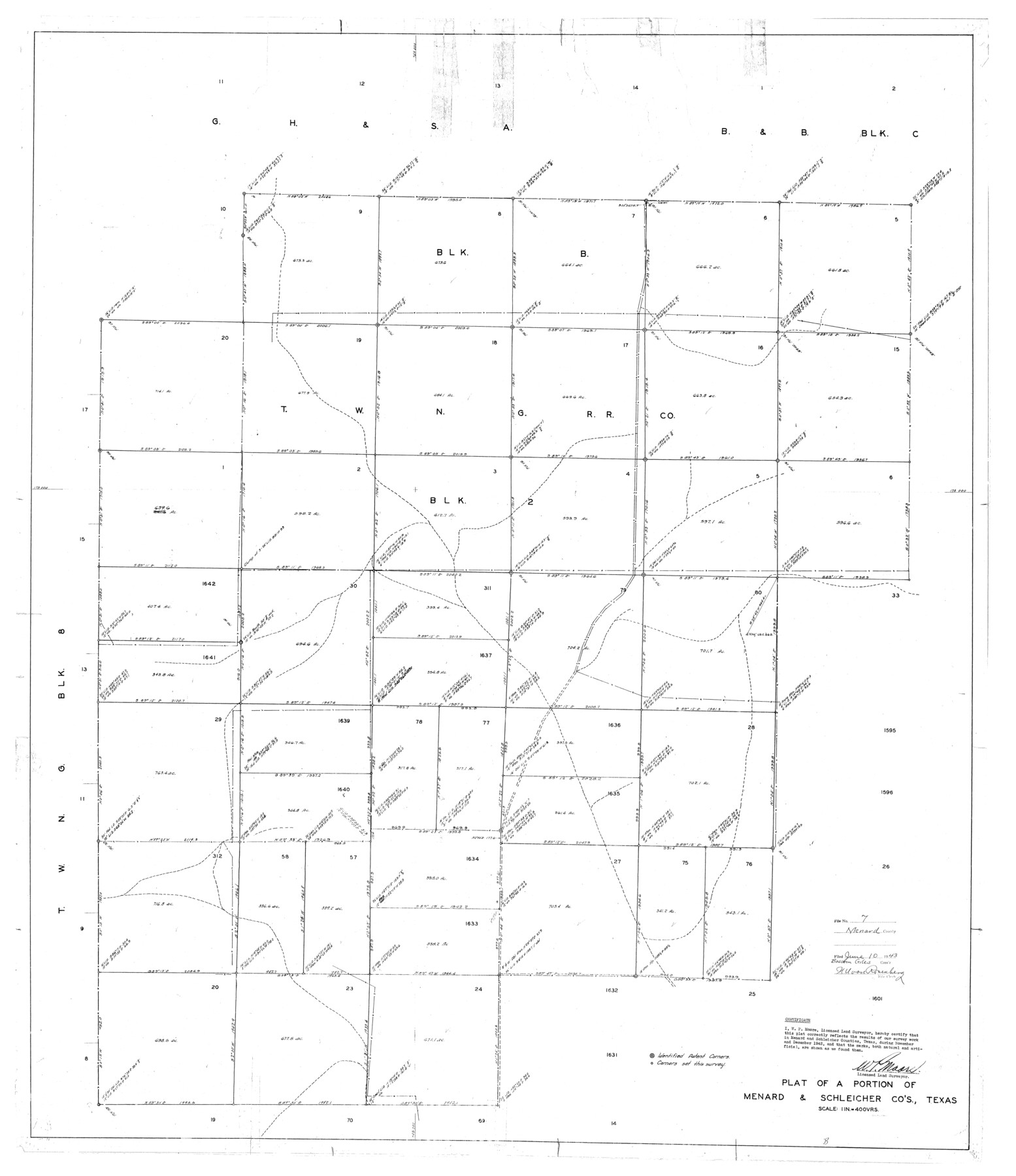
Menard County Rolled Sketch 7
Plat of a portion of Menard & Schleicher Cos., Texas
-
Map/Doc
9509
-
Collection
General Map Collection
-
Object Dates
1942 (Survey Date)
1943/6/10 (File Date)
-
People and Organizations
W.P. Moore (Surveyor/Engineer)
-
Counties
Menard Schleicher
-
Subjects
Surveying Rolled Sketch
-
Height x Width
43.2 x 37.3 inches
109.7 x 94.7 cm
-
Scale
1" = 400 varas
-
Comments
See Menard County Sketch File 27 (31564) for report.
Related maps
Menard County Sketch File 27

Print $8.00
- Digital $50.00
Menard County Sketch File 27
1943
Size 11.2 x 8.8 inches
Map/Doc 31564
Part of: General Map Collection
Trinity County Working Sketch 14

Print $20.00
- Digital $50.00
Trinity County Working Sketch 14
1956
Size 24.8 x 29.9 inches
Map/Doc 69463
Duval County Boundary File 2

Print $32.00
- Digital $50.00
Duval County Boundary File 2
Size 12.4 x 8.1 inches
Map/Doc 52703
Hopkins County Working Sketch 2

Print $20.00
- Digital $50.00
Hopkins County Working Sketch 2
1954
Size 25.3 x 21.2 inches
Map/Doc 66227
Schleicher County

Print $40.00
- Digital $50.00
Schleicher County
1898
Size 35.0 x 52.8 inches
Map/Doc 78396
Live Oak County Working Sketch 13

Print $20.00
- Digital $50.00
Live Oak County Working Sketch 13
1957
Size 42.1 x 38.7 inches
Map/Doc 70598
Nueces County Sketch File 35

Print $2.00
- Digital $50.00
Nueces County Sketch File 35
1913
Size 13.1 x 4.8 inches
Map/Doc 32613

Baylor County Sketch File 25

Print $46.00
- Digital $50.00
Baylor County Sketch File 25
1954
Size 11.5 x 9.0 inches
Map/Doc 14212
Refugio County NRC Article 33.136 Sketch 2

Print $26.00
- Digital $50.00
Refugio County NRC Article 33.136 Sketch 2
2003
Size 24.5 x 36.5 inches
Map/Doc 78536
Briscoe County Sketch File E

Print $40.00
- Digital $50.00
Briscoe County Sketch File E
Size 26.0 x 33.7 inches
Map/Doc 11003
Kerr County Sketch File 23

Print $8.00
- Digital $50.00
Kerr County Sketch File 23
1959
Size 14.2 x 8.8 inches
Map/Doc 28901
[Surveys in Mills, Hamilton, Coryell and Bell Counties]
![78362, [Surveys in Mills, Hamilton, Coryell and Bell Counties], General Map Collection](https://historictexasmaps.com/wmedia_w700/maps/78362.tif.jpg)
Print $20.00
- Digital $50.00
[Surveys in Mills, Hamilton, Coryell and Bell Counties]
Size 33.9 x 19.5 inches
Map/Doc 78362
You may also like
Comanche County Working Sketch 12

Print $20.00
- Digital $50.00
Comanche County Working Sketch 12
1957
Size 15.4 x 25.5 inches
Map/Doc 68146
Galveston County Rolled Sketch 47

Print $20.00
- Digital $50.00
Galveston County Rolled Sketch 47
1999
Size 24.6 x 36.7 inches
Map/Doc 77534
Marion County Working Sketch 11

Print $20.00
- Digital $50.00
Marion County Working Sketch 11
1952
Size 23.8 x 28.7 inches
Map/Doc 70786
Map of Galveston, Turtle & East Bays & portions of the Gulf of Mexico in Chambers & Galveston Counties, Texas showing subdivision for mineral development

Print $40.00
- Digital $50.00
Map of Galveston, Turtle & East Bays & portions of the Gulf of Mexico in Chambers & Galveston Counties, Texas showing subdivision for mineral development
1949
Size 48.9 x 54.8 inches
Map/Doc 2977
The Republic County of Jackson. September 17, 1838

Print $20.00
The Republic County of Jackson. September 17, 1838
2020
Size 15.6 x 21.8 inches
Map/Doc 96185
Fannin County

Print $20.00
- Digital $50.00
Fannin County
1946
Size 42.3 x 37.4 inches
Map/Doc 73145
Refugio County Boundary File 6a

Print $20.00
- Digital $50.00
Refugio County Boundary File 6a
Size 14.4 x 9.0 inches
Map/Doc 58262
McMullen County Sketch File 10

Print $40.00
- Digital $50.00
McMullen County Sketch File 10
1876
Size 14.3 x 17.6 inches
Map/Doc 31353
[Worksheets related to the Wilson Strickland survey and vicinity]
![89715, [Vicinity and related to the Wilson Strickland Survey], Twichell Survey Records](https://historictexasmaps.com/wmedia_w700/maps/89715-1.tif.jpg)
Print $20.00
- Digital $50.00
[Worksheets related to the Wilson Strickland survey and vicinity]
Size 34.7 x 43.0 inches
Map/Doc 89715
[Blocks 1 and H]
![90719, [Blocks 1 and H], Twichell Survey Records](https://historictexasmaps.com/wmedia_w700/maps/90719-1.tif.jpg)
Print $20.00
- Digital $50.00
[Blocks 1 and H]
Size 27.1 x 21.6 inches
Map/Doc 90719
Map of the State of Texas Showing Original Land Districts

Print $20.00
- Digital $50.00
Map of the State of Texas Showing Original Land Districts
1891
Size 43.7 x 43.3 inches
Map/Doc 73598
Wise County Working Sketch 27

Print $20.00
- Digital $50.00
Wise County Working Sketch 27
1988
Size 28.0 x 37.2 inches
Map/Doc 72641