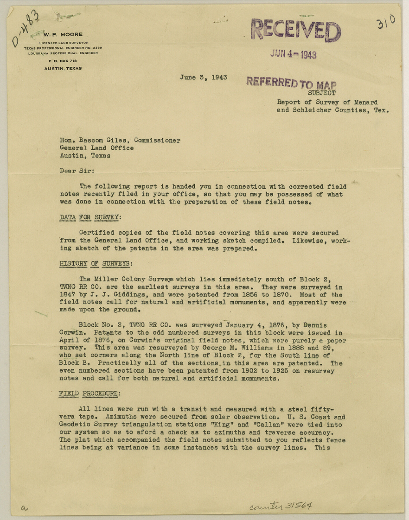
Menard County Sketch File 27
[Surveyor's report of surveys in G. H. & S. A. Block B and T. W. N. G. Block 2]
-
Map/Doc
31564
-
Collection
General Map Collection
-
Object Dates
6/3/1943 (Creation Date)
6/10/1943 (File Date)
6/3/1943 (Correspondence Date)
6/5/1943 (Correspondence Date)
-
People and Organizations
W.P. Moore (Surveyor/Engineer)
J.J. Giddings (Surveyor/Engineer)
George M. Williams (Surveyor/Engineer)
D.H. Clark (Surveyor/Engineer)
D.W. Maddox (Surveyor/Engineer)
-
Counties
Menard Schleicher
-
Subjects
Surveying Sketch File
-
Height x Width
11.2 x 8.8 inches
28.5 x 22.4 cm
-
Medium
paper, print
-
Comments
See Menard County Rolled Sketch 7 (9509) for sketch.
-
Features
San Saba River
Related maps
Menard County Rolled Sketch 7

Print $20.00
- Digital $50.00
Menard County Rolled Sketch 7
Size 43.2 x 37.3 inches
Map/Doc 9509
Part of: General Map Collection
Flight Mission No. BRA-16M, Frame 84, Jefferson County

Print $20.00
- Digital $50.00
Flight Mission No. BRA-16M, Frame 84, Jefferson County
1953
Size 18.6 x 22.1 inches
Map/Doc 85696
Duval County Boundary File 1d

Print $40.00
- Digital $50.00
Duval County Boundary File 1d
Size 6.6 x 47.7 inches
Map/Doc 52699
El Paso County Sketch File 11

Print $6.00
- Digital $50.00
El Paso County Sketch File 11
Size 14.2 x 11.0 inches
Map/Doc 22000
Harbor of Brazos Santiago, Texas

Print $20.00
- Digital $50.00
Harbor of Brazos Santiago, Texas
1887
Size 27.2 x 18.4 inches
Map/Doc 72996
Gregg County Rolled Sketch 26

Print $40.00
- Digital $50.00
Gregg County Rolled Sketch 26
1937
Size 25.8 x 129.0 inches
Map/Doc 9077
Bastrop County Boundary File 3

Print $48.00
- Digital $50.00
Bastrop County Boundary File 3
1925
Size 11.3 x 8.7 inches
Map/Doc 50320
Martin County Working Sketch 2

Print $20.00
- Digital $50.00
Martin County Working Sketch 2
1944
Size 27.5 x 20.9 inches
Map/Doc 70820
Culberson County Rolled Sketch 36

Print $20.00
- Digital $50.00
Culberson County Rolled Sketch 36
1934
Size 32.5 x 23.2 inches
Map/Doc 8750
Borden County Working Sketch 5

Print $20.00
- Digital $50.00
Borden County Working Sketch 5
1944
Size 35.1 x 45.2 inches
Map/Doc 67465
Nueces County Rolled Sketch 99

Print $92.00
Nueces County Rolled Sketch 99
1985
Size 24.2 x 36.6 inches
Map/Doc 7060
Flight Mission No. DQN-6K, Frame 11, Calhoun County

Print $20.00
- Digital $50.00
Flight Mission No. DQN-6K, Frame 11, Calhoun County
1953
Size 18.4 x 22.2 inches
Map/Doc 84433
St. L. S-W. Ry. of Texas Map of Lufkin Branch in Cherokee County Texas

Print $40.00
- Digital $50.00
St. L. S-W. Ry. of Texas Map of Lufkin Branch in Cherokee County Texas
1912
Size 23.3 x 122.0 inches
Map/Doc 64020
You may also like
Menard County Sketch File 15

Print $8.00
- Digital $50.00
Menard County Sketch File 15
1892
Size 12.9 x 8.3 inches
Map/Doc 31510
Dickens County Rolled Sketch K

Print $20.00
- Digital $50.00
Dickens County Rolled Sketch K
1905
Size 38.7 x 21.7 inches
Map/Doc 5713
Wichita County Sketch File 1

Print $22.00
- Digital $50.00
Wichita County Sketch File 1
1856
Size 13.5 x 16.8 inches
Map/Doc 40028
Grayson County Boundary File 3a

Print $25.00
- Digital $50.00
Grayson County Boundary File 3a
Size 8.3 x 16.9 inches
Map/Doc 53945
Flight Mission No. DCL-7C, Frame 120, Kenedy County

Print $20.00
- Digital $50.00
Flight Mission No. DCL-7C, Frame 120, Kenedy County
1943
Size 18.5 x 22.4 inches
Map/Doc 86085
Real County Sketch File 15

Print $8.00
- Digital $50.00
Real County Sketch File 15
1933
Size 14.3 x 8.6 inches
Map/Doc 35069
Jones County Sketch File 14

Print $4.00
- Digital $50.00
Jones County Sketch File 14
1882
Size 11.7 x 8.8 inches
Map/Doc 28501
Concho County Sketch File 37

Print $20.00
- Digital $50.00
Concho County Sketch File 37
1938
Size 18.7 x 29.1 inches
Map/Doc 11162
Flight Mission No. BRE-2P, Frame 22, Nueces County

Print $20.00
- Digital $50.00
Flight Mission No. BRE-2P, Frame 22, Nueces County
1956
Size 18.7 x 22.6 inches
Map/Doc 86731
Timely Tips to Texas Truckers

Timely Tips to Texas Truckers
1906
Size 9.3 x 6.2 inches
Map/Doc 96609
North end of Brazos Island

Print $20.00
- Digital $50.00
North end of Brazos Island
Size 26.0 x 18.3 inches
Map/Doc 72915
Haskell County Rolled Sketch 9

Print $20.00
- Digital $50.00
Haskell County Rolled Sketch 9
Size 16.4 x 34.3 inches
Map/Doc 6168