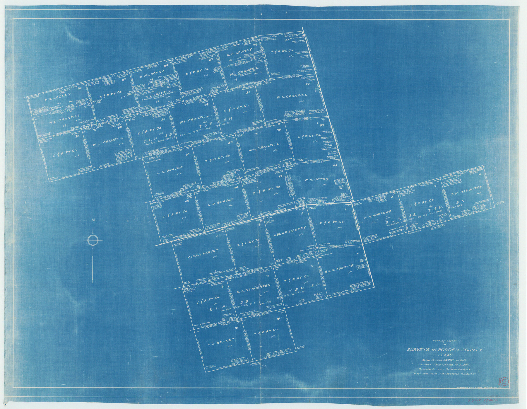
Borden County Working Sketch 5
-
Map/Doc
67465
-
Collection
General Map Collection
-
Object Dates
5/1/1944 (Creation Date)
-
People and Organizations
Bascom Giles (GLO Commissioner)
F.H. Becker (Draftsman)
-
Counties
Borden
-
Subjects
Surveying Working Sketch
-
Height x Width
35.1 x 45.2 inches
89.2 x 114.8 cm
-
Scale
1" = 500 varas
-
Comments
Surveys located about 17 miles South 43 degrees West of Gail, Texas.
Part of: General Map Collection
Culberson County Rolled Sketch 10

Print $20.00
- Digital $50.00
Culberson County Rolled Sketch 10
1893
Size 16.4 x 25.9 inches
Map/Doc 5647
Randall County

Print $20.00
- Digital $50.00
Randall County
1958
Size 41.0 x 33.0 inches
Map/Doc 77402
Gregg County Rolled Sketch 25

Print $40.00
- Digital $50.00
Gregg County Rolled Sketch 25
1933
Size 27.3 x 51.7 inches
Map/Doc 9076
Eastland County Sketch File A

Print $20.00
- Digital $50.00
Eastland County Sketch File A
1887
Size 18.1 x 16.8 inches
Map/Doc 11413
Crane County Working Sketch 31

Print $20.00
- Digital $50.00
Crane County Working Sketch 31
1982
Size 34.3 x 37.7 inches
Map/Doc 68308
Haskell County Sketch File 7

Print $22.00
- Digital $50.00
Haskell County Sketch File 7
Size 7.8 x 13.4 inches
Map/Doc 26128
Fayette County Working Sketch 11

Print $20.00
- Digital $50.00
Fayette County Working Sketch 11
1990
Size 30.8 x 35.0 inches
Map/Doc 69175
Gaines County Sketch File 10

Print $40.00
- Digital $50.00
Gaines County Sketch File 10
Size 16.4 x 14.0 inches
Map/Doc 23193
Brewster County Rolled Sketch 52

Print $40.00
- Digital $50.00
Brewster County Rolled Sketch 52
1935
Size 24.5 x 59.4 inches
Map/Doc 8479
Flight Mission No. DAG-17K, Frame 78, Matagorda County

Print $20.00
- Digital $50.00
Flight Mission No. DAG-17K, Frame 78, Matagorda County
1952
Size 18.7 x 22.4 inches
Map/Doc 86337
Montgomery County Sketch File 6

Print $4.00
- Digital $50.00
Montgomery County Sketch File 6
Size 4.6 x 5.7 inches
Map/Doc 31781
Aransas County Rolled Sketch 12

Print $20.00
- Digital $50.00
Aransas County Rolled Sketch 12
Size 17.6 x 11.1 inches
Map/Doc 77191
You may also like
Duval County Rolled Sketch 38

Print $20.00
- Digital $50.00
Duval County Rolled Sketch 38
1937
Size 22.6 x 16.1 inches
Map/Doc 5755
Harris County Rolled Sketch 40

Print $20.00
- Digital $50.00
Harris County Rolled Sketch 40
1913
Size 20.3 x 23.1 inches
Map/Doc 6098
Burma, Thailand, Indochina and Malayan Federation

Print $3.00
- Digital $50.00
Burma, Thailand, Indochina and Malayan Federation
Size 10.7 x 14.6 inches
Map/Doc 92375
Burleson County Working Sketch 2

Print $20.00
- Digital $50.00
Burleson County Working Sketch 2
1976
Size 36.4 x 31.2 inches
Map/Doc 67721
Coryell County Working Sketch 4

Print $20.00
- Digital $50.00
Coryell County Working Sketch 4
1929
Size 23.8 x 18.3 inches
Map/Doc 68211
[John S. Stephens Blk. S2, Lgs. 174-177, 186-193, 201-209]
![90104, [John S. Stephens Blk. S2, Lgs. 174-177, 186-193, 201-209], Twichell Survey Records](https://historictexasmaps.com/wmedia_w700/maps/90104-1.tif.jpg)
Print $2.00
- Digital $50.00
[John S. Stephens Blk. S2, Lgs. 174-177, 186-193, 201-209]
1912
Size 11.3 x 8.8 inches
Map/Doc 90104
Fisher County Boundary File 3

Print $32.00
- Digital $50.00
Fisher County Boundary File 3
Size 8.2 x 4.2 inches
Map/Doc 53428
Flight Mission No. DAG-23K, Frame 170, Matagorda County

Print $20.00
- Digital $50.00
Flight Mission No. DAG-23K, Frame 170, Matagorda County
1953
Size 18.6 x 22.4 inches
Map/Doc 86508
Bryant's Railroad Guide, the Tourists' and Emigrants' Hand-book of Travel

Print $260.00
- Digital $50.00
Bryant's Railroad Guide, the Tourists' and Emigrants' Hand-book of Travel
1875
Size 9.3 x 6.0 inches
Map/Doc 93627
T. C. Ivey Ranch Block D

Print $20.00
- Digital $50.00
T. C. Ivey Ranch Block D
Size 17.5 x 14.8 inches
Map/Doc 92846
[United States]
![97197, [United States], General Map Collection](https://historictexasmaps.com/wmedia_w700/maps/97197.tif.jpg)
Print $20.00
- Digital $50.00
[United States]
1848
Size 17.7 x 37.4 inches
Map/Doc 97197
Missouri, Kansas & Texas Railway in Morris County

Print $20.00
- Digital $50.00
Missouri, Kansas & Texas Railway in Morris County
1906
Size 14.9 x 36.2 inches
Map/Doc 64274