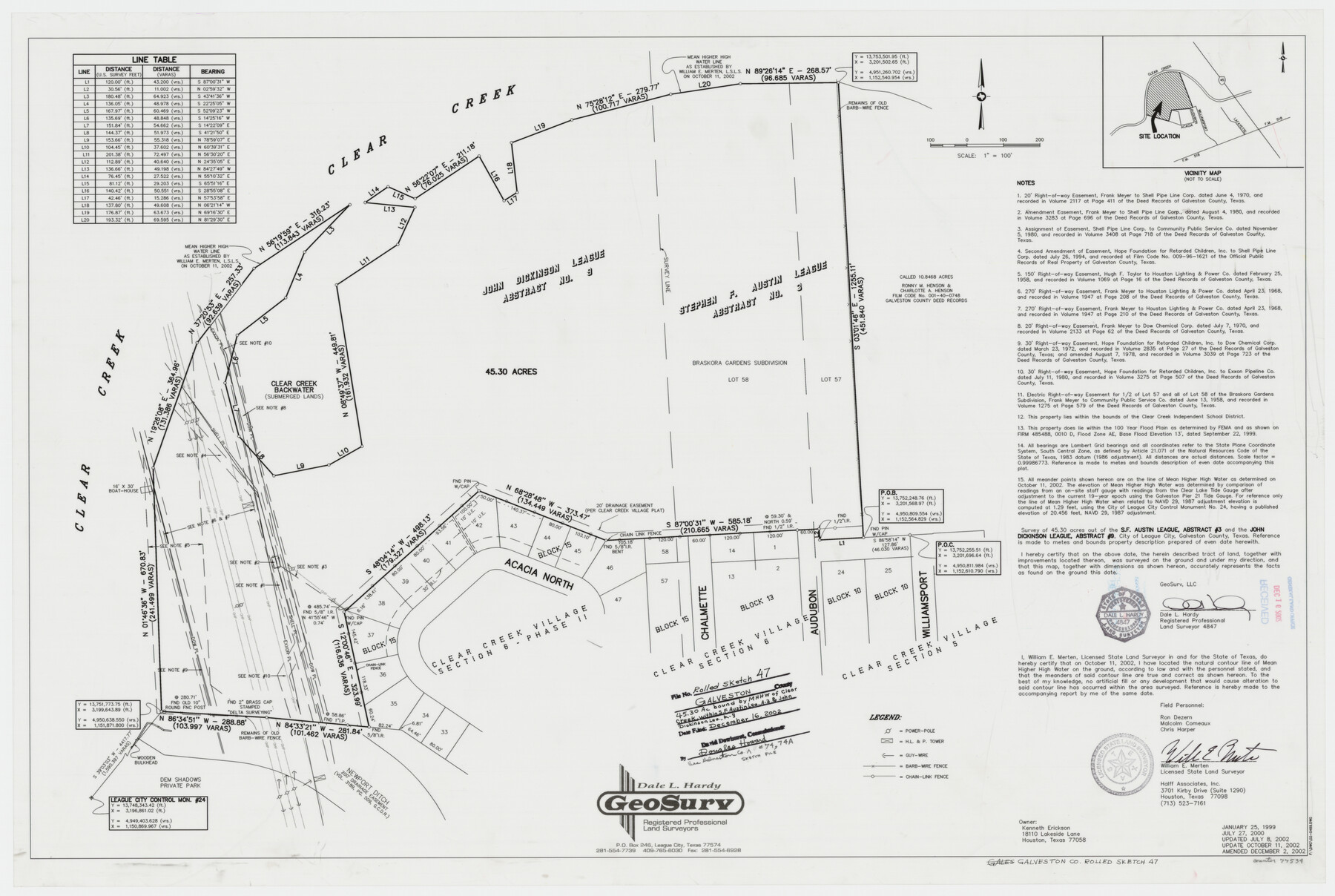
Galveston County Rolled Sketch 47
Survey of 45.30 acres out of the S.F. Austin League, abstract 3 and the John Dickinson League, abstract 9
-
Map/Doc
77534
-
Collection
General Map Collection
-
Object Dates
2002/12/2 (Revision Date)
2002/12/16 (File Date)
2002/10/11 (Survey Date)
1999/1/25 (Creation Date)
2000/7/27 (Revision Date)
2002/7/8 (Revision Date)
-
People and Organizations
Dale L. Hardy (Surveyor/Engineer)
William E. Merten (Surveyor/Engineer)
Ron Dezern (Chainman/Field Personnel)
Malcolm Comeaux (Chainman/Field Personnel)
Chris Harper (Chainman/Field Personnel)
-
Counties
Galveston
-
Subjects
Surveying Rolled Sketch
-
Height x Width
24.6 x 36.7 inches
62.5 x 93.2 cm
-
Medium
mylar, print
-
Scale
1" = 100 feet
-
Comments
See Galveston County Sketch File 74 (77526) for report.
Related maps
Galveston County Sketch File 74

Print $12.00
- Digital $50.00
Galveston County Sketch File 74
2002
Size 11.3 x 8.7 inches
Map/Doc 77526
Part of: General Map Collection
Right of Way and Track Map, Galveston, Harrisburg & San Antonio Ry. operated by the T. & N. O. R.R. Co., Victoria Division, Rosenberg to Beeville

Print $40.00
- Digital $50.00
Right of Way and Track Map, Galveston, Harrisburg & San Antonio Ry. operated by the T. & N. O. R.R. Co., Victoria Division, Rosenberg to Beeville
Size 24.3 x 55.8 inches
Map/Doc 76162

Bell County Sketch File 17

Print $4.00
- Digital $50.00
Bell County Sketch File 17
Size 8.1 x 9.1 inches
Map/Doc 14398
Flight Mission No. DQO-8K, Frame 42, Galveston County

Print $20.00
- Digital $50.00
Flight Mission No. DQO-8K, Frame 42, Galveston County
1952
Size 18.5 x 22.3 inches
Map/Doc 85149
Plat of Re-survey Section 8, Block 66 1/2, Public School Land

Print $2.00
- Digital $50.00
Plat of Re-survey Section 8, Block 66 1/2, Public School Land
1972
Size 11.3 x 8.7 inches
Map/Doc 60299

Brewster County Sketch File 54

Print $4.00
- Digital $50.00
Brewster County Sketch File 54
1963
Size 11.0 x 8.5 inches
Map/Doc 16383
Right of Way and Track Map, the Missouri, Kansas & Texas Ry. Of Texas operated by the Missouri, Kansas & Texas Ry. Of Texas, Houston Division

Print $40.00
- Digital $50.00
Right of Way and Track Map, the Missouri, Kansas & Texas Ry. Of Texas operated by the Missouri, Kansas & Texas Ry. Of Texas, Houston Division
1918
Size 25.5 x 61.9 inches
Map/Doc 64567
Knox County Sketch File 27

Print $20.00
- Digital $50.00
Knox County Sketch File 27
1963
Size 20.3 x 19.7 inches
Map/Doc 11964
Sutton County Sketch File 22

Print $4.00
- Digital $50.00
Sutton County Sketch File 22
Size 14.2 x 8.5 inches
Map/Doc 37459
Boundary Between the United States & Mexico Agreed Upon by the Joint Commission under the Treaty of Guadalupe Hidalgo

Print $4.00
- Digital $50.00
Boundary Between the United States & Mexico Agreed Upon by the Joint Commission under the Treaty of Guadalupe Hidalgo
1853
Size 24.0 x 17.6 inches
Map/Doc 65391
Aransas County Working Sketch 22

Print $20.00
- Digital $50.00
Aransas County Working Sketch 22
Size 24.3 x 18.2 inches
Map/Doc 67189
You may also like
[Nueces Bay Islands and Nesting Birds]
![2084, [Nueces Bay Islands and Nesting Birds], General Map Collection](https://historictexasmaps.com/wmedia_w700/maps/2084.tif.jpg)
Print $20.00
- Digital $50.00
[Nueces Bay Islands and Nesting Birds]
1940
Size 18.1 x 24.2 inches
Map/Doc 2084
Utility Map, Low Rent Housing Project Texas 18-1, Housing Authority of the City of Lubbock (Plan No. 3)

Print $20.00
- Digital $50.00
Utility Map, Low Rent Housing Project Texas 18-1, Housing Authority of the City of Lubbock (Plan No. 3)
1941
Size 42.5 x 27.3 inches
Map/Doc 92758
Fort Bend County Working Sketch 26

Print $20.00
- Digital $50.00
Fort Bend County Working Sketch 26
1982
Size 18.5 x 23.6 inches
Map/Doc 69232
Schleicher County Working Sketch 21

Print $20.00
- Digital $50.00
Schleicher County Working Sketch 21
1953
Size 26.6 x 10.8 inches
Map/Doc 63823
Williamson County Sketch File 15

Print $4.00
- Digital $50.00
Williamson County Sketch File 15
Size 10.0 x 8.0 inches
Map/Doc 40334

Map of the Fort Worth & Denver City Railway

Print $20.00
- Digital $50.00
Map of the Fort Worth & Denver City Railway
1887
Size 19.3 x 15.1 inches
Map/Doc 64434
El Paso County Sketch File 19

Print $30.00
- Digital $50.00
El Paso County Sketch File 19
1905
Size 13.3 x 8.7 inches
Map/Doc 22009
Hardeman County Sketch File A2

Print $20.00
- Digital $50.00
Hardeman County Sketch File A2
Size 28.5 x 17.3 inches
Map/Doc 11631
Amistad International Reservoir on Rio Grande 107

Print $20.00
- Digital $50.00
Amistad International Reservoir on Rio Grande 107
1950
Size 28.4 x 40.9 inches
Map/Doc 75538
Flight Mission No. DCL-5C, Frame 70, Kenedy County

Print $20.00
- Digital $50.00
Flight Mission No. DCL-5C, Frame 70, Kenedy County
1943
Size 18.7 x 22.2 inches
Map/Doc 85853
[Connections of Blocks C-17, B-59, T6 and C-11]
![93067, [Connections of Blocks C-17, B-59, T6 and C-11], Twichell Survey Records](https://historictexasmaps.com/wmedia_w700/maps/93067-1.tif.jpg)
Print $20.00
- Digital $50.00
[Connections of Blocks C-17, B-59, T6 and C-11]
Size 31.2 x 28.0 inches
Map/Doc 93067