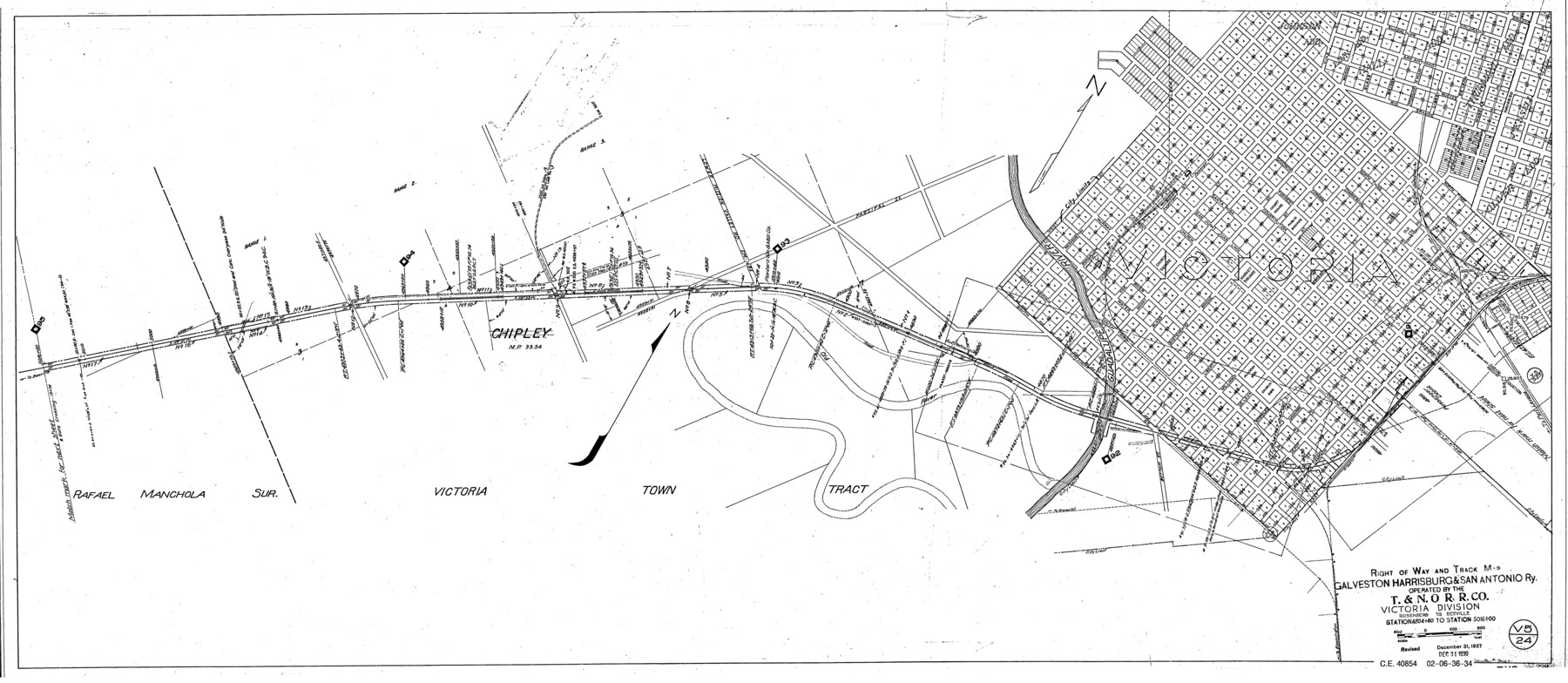
Right of Way and Track Map, Galveston, Harrisburg & San Antonio Ry. operated by the T. & N. O. R.R. Co., Victoria Division, Rosenberg to Beeville
Station 4804+80 to Station 5016+00
Z-2-207
-
Map/Doc
76162
-
Collection
General Map Collection
-
Object Dates
1927/12/31 (Revision Date)
1930/12/31 (Revision Date)
-
People and Organizations
Phillip Szurgot (Donor)
-
Counties
Victoria
-
Subjects
Railroads
-
Height x Width
24.3 x 55.8 inches
61.7 x 141.7 cm
-
Medium
paper, photocopy
-
Comments
Donated by Phillip Szurgot of CDS/Muery Services, San Antonio, June 28, 2002.
See 76157 through 76164 for all segments. -
Features
GH&SA
T&NO
Victoria
Guadalupe River
Chipley
Part of: General Map Collection
Flight Mission No. BRE-2P, Frame 107, Nueces County

Print $20.00
- Digital $50.00
Flight Mission No. BRE-2P, Frame 107, Nueces County
1956
Size 18.5 x 22.7 inches
Map/Doc 86792
Pecos County Rolled Sketch 153

Print $20.00
- Digital $50.00
Pecos County Rolled Sketch 153
1960
Size 20.2 x 22.7 inches
Map/Doc 7282
Flight Mission No. CRC-2R, Frame 191, Chambers County

Print $20.00
- Digital $50.00
Flight Mission No. CRC-2R, Frame 191, Chambers County
1956
Size 18.6 x 22.4 inches
Map/Doc 84769
Outer Continental Shelf Leasing Maps (Texas Offshore Operations)

Print $20.00
- Digital $50.00
Outer Continental Shelf Leasing Maps (Texas Offshore Operations)
Size 17.6 x 13.8 inches
Map/Doc 75844
Flight Mission No. CGI-4N, Frame 182, Cameron County

Print $20.00
- Digital $50.00
Flight Mission No. CGI-4N, Frame 182, Cameron County
1955
Size 18.4 x 22.2 inches
Map/Doc 84685
Reagan County Working Sketch 46b

Print $20.00
- Digital $50.00
Reagan County Working Sketch 46b
1987
Size 31.4 x 45.2 inches
Map/Doc 71889

Jackson County Boundary File 1

Print $24.00
- Digital $50.00
Jackson County Boundary File 1
Size 9.0 x 3.9 inches
Map/Doc 55420
Upton County Sketch File 25

Print $20.00
- Digital $50.00
Upton County Sketch File 25
1928
Size 27.1 x 44.4 inches
Map/Doc 10415
Menard County Sketch File 2

Print $22.00
- Digital $50.00
Menard County Sketch File 2
1881
Size 7.9 x 12.8 inches
Map/Doc 31486
Gillespie County Rolled Sketch 10

Print $3.00
- Digital $50.00
Gillespie County Rolled Sketch 10
2017
Size 16.1 x 10.7 inches
Map/Doc 94413
Nueces County Rolled Sketch 10

Print $40.00
- Digital $50.00
Nueces County Rolled Sketch 10
Size 31.6 x 55.4 inches
Map/Doc 8350
You may also like
Current Miscellaneous File 116

Print $8.00
- Digital $50.00
Current Miscellaneous File 116
Size 11.3 x 8.8 inches
Map/Doc 74819
Lubbock County Lines

Print $20.00
- Digital $50.00
Lubbock County Lines
1892
Size 22.7 x 22.6 inches
Map/Doc 91308
Flight Mission No. DAG-23K, Frame 163, Matagorda County

Print $20.00
- Digital $50.00
Flight Mission No. DAG-23K, Frame 163, Matagorda County
1953
Size 18.6 x 22.4 inches
Map/Doc 86501
Karnes County Boundary File 5b

Print $78.00
- Digital $50.00
Karnes County Boundary File 5b
Size 7.4 x 6.1 inches
Map/Doc 55723
Menard County Rolled Sketch 2

Print $20.00
- Digital $50.00
Menard County Rolled Sketch 2
1883
Size 25.0 x 19.9 inches
Map/Doc 6752
Stanton Acres, a Subdivision of Tracts 2 and 3, Block 1; and Tract 1, Block 2]
![91336, Stanton Acres, a Subdivision of Tracts 2 and 3, Block 1; and Tract 1, Block 2], Twichell Survey Records](https://historictexasmaps.com/wmedia_w700/maps/91336-1.tif.jpg)
Print $3.00
- Digital $50.00
Stanton Acres, a Subdivision of Tracts 2 and 3, Block 1; and Tract 1, Block 2]
Size 9.4 x 11.8 inches
Map/Doc 91336
Gaines County Rolled Sketch 2

Print $40.00
- Digital $50.00
Gaines County Rolled Sketch 2
1901
Size 23.3 x 70.9 inches
Map/Doc 9012
Brazoria County, Texas

Print $20.00
- Digital $50.00
Brazoria County, Texas
1877
Size 24.7 x 21.7 inches
Map/Doc 425
Duval County Sketch File 66

Print $12.00
- Digital $50.00
Duval County Sketch File 66
1944
Size 14.5 x 8.8 inches
Map/Doc 21444
Culberson County Rolled Sketch 19A
Print $20.00
- Digital $50.00
Culberson County Rolled Sketch 19A
Size 23.2 x 28.6 inches
Map/Doc 5652
Sutton County Sketch File 44

Print $6.00
- Digital $50.00
Sutton County Sketch File 44
1939
Size 11.3 x 8.7 inches
Map/Doc 37512
Borden County Sketch File 8

Print $2.00
- Digital $50.00
Borden County Sketch File 8
1934
Size 11.5 x 7.3 inches
Map/Doc 14727