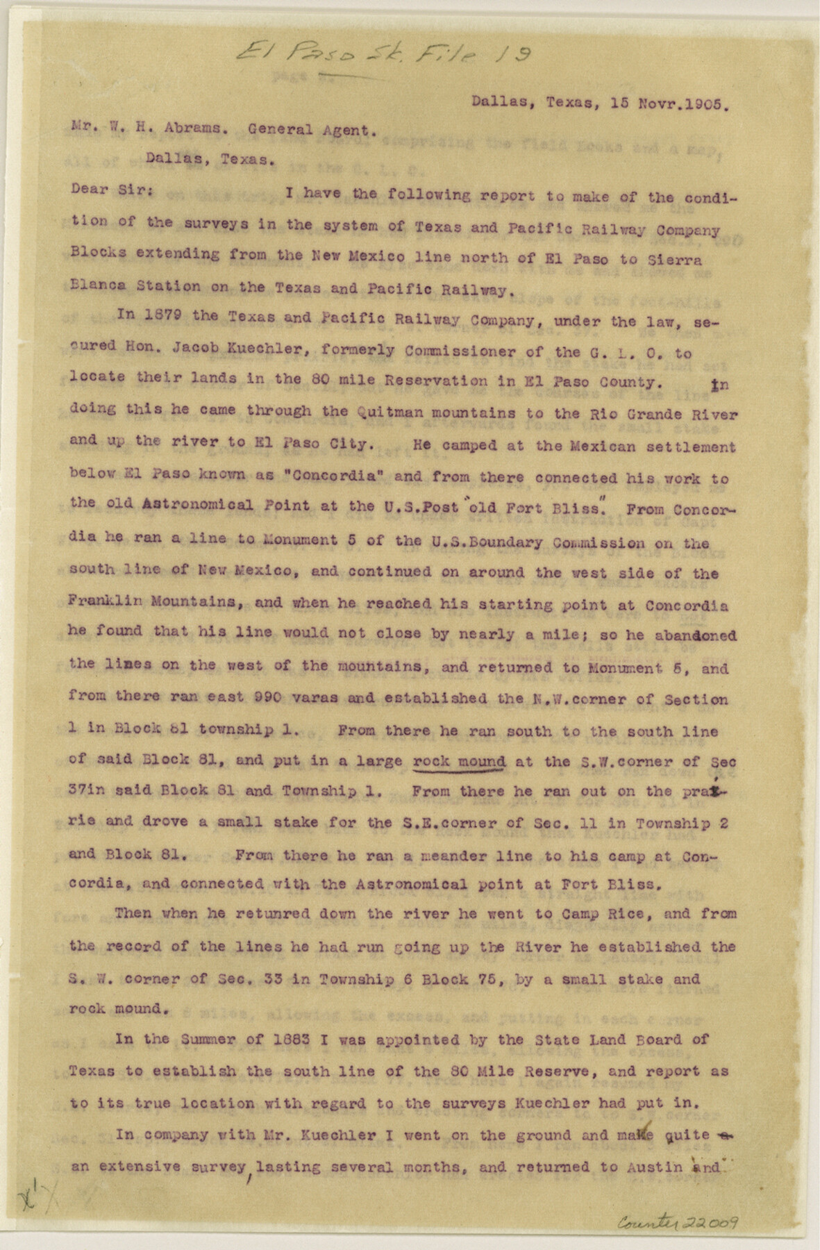
El Paso County Sketch File 19
[Sketches and report on the Texas and Pacific Blocks in El Paso County]
-
Map/Doc
22009
-
Collection
General Map Collection
-
Object Dates
11/15/1905 (Creation Date)
11/20/1905 (File Date)
-
People and Organizations
Paul McCombs (Surveyor/Engineer)
W.H. Abrams (Agent)
-
Counties
El Paso
-
Subjects
Surveying Sketch File
-
Height x Width
13.3 x 8.7 inches
33.8 x 22.1 cm
-
Medium
multi-page, multi-format
-
Features
San Ygnacio
San Elizario
Rio Bravo del Norte
Socorro
Rivera
Ysleta
Rio Vienco
New U.S. Military Post
Hueco Mountains
San Juan Mountains
El Paso & White Oak Railroad
Lanoria
EP&NE
Southern Pacific Railroad Company
Iser
El Paso
Pierpoint
Fabens
Rio Grande
GH&SA
Presidio de San Elizario
Aroyo [sic] de los Comales
Camp Rice
Franklin Mountains
Old Fort Bliss
Concordia
Rio Grande
Quitman Mountains
T&P
Sierra Blanca Station
Part of: General Map Collection
Potter County Sketch File 10

Print $40.00
- Digital $50.00
Potter County Sketch File 10
Size 58.9 x 37.7 inches
Map/Doc 10576
United States of North America (Eastern and Central)

Print $20.00
- Digital $50.00
United States of North America (Eastern and Central)
1862
Size 19.3 x 26.2 inches
Map/Doc 93667
Presidio County Working Sketch 111

Print $20.00
- Digital $50.00
Presidio County Working Sketch 111
1981
Size 17.1 x 20.4 inches
Map/Doc 71788
Reeves County Boundary File 81 1/2

Print $54.00
- Digital $50.00
Reeves County Boundary File 81 1/2
Size 9.7 x 8.3 inches
Map/Doc 58216
[Galveston, Harrisburg & San Antonio through El Paso County]
![64002, [Galveston, Harrisburg & San Antonio through El Paso County], General Map Collection](https://historictexasmaps.com/wmedia_w700/maps/64002.tif.jpg)
Print $20.00
- Digital $50.00
[Galveston, Harrisburg & San Antonio through El Paso County]
1907
Size 13.6 x 33.9 inches
Map/Doc 64002
Dickens County Rolled Sketch C & C1

Print $35.00
- Digital $50.00
Dickens County Rolled Sketch C & C1
1895
Size 10.6 x 15.5 inches
Map/Doc 44297
Presidio County Rolled Sketch 123

Print $40.00
- Digital $50.00
Presidio County Rolled Sketch 123
Size 49.3 x 38.2 inches
Map/Doc 9798
Montgomery County Rolled Sketch 10

Print $20.00
- Digital $50.00
Montgomery County Rolled Sketch 10
1905
Size 35.5 x 26.2 inches
Map/Doc 6796
Cherokee County Working Sketch 10

Print $40.00
- Digital $50.00
Cherokee County Working Sketch 10
1957
Size 58.1 x 43.2 inches
Map/Doc 67965
Wichita County Boundary File 2b

Print $4.00
- Digital $50.00
Wichita County Boundary File 2b
Size 8.9 x 8.8 inches
Map/Doc 59911
Flight Mission No. BQY-14M, Frame 182, Harris County

Print $20.00
- Digital $50.00
Flight Mission No. BQY-14M, Frame 182, Harris County
1953
Size 18.5 x 22.4 inches
Map/Doc 85298
Lamb County Rolled Sketch 3

Print $20.00
- Digital $50.00
Lamb County Rolled Sketch 3
1917
Size 23.0 x 42.5 inches
Map/Doc 9413
You may also like
Comal County Rolled Sketch 2

Print $20.00
- Digital $50.00
Comal County Rolled Sketch 2
1974
Size 21.8 x 13.3 inches
Map/Doc 5537
Reconnoissance of Sabine River and Valley

Print $20.00
Reconnoissance of Sabine River and Valley
1863
Size 30.2 x 42.3 inches
Map/Doc 97499

Rhyne Simpson Quirt Ave. Addition to the City of Lubbock

Print $20.00
- Digital $50.00
Rhyne Simpson Quirt Ave. Addition to the City of Lubbock
1951
Size 17.2 x 21.2 inches
Map/Doc 92878
Flight Mission No. CRC-3R, Frame 103, Chambers County

Print $20.00
- Digital $50.00
Flight Mission No. CRC-3R, Frame 103, Chambers County
1956
Size 18.7 x 22.4 inches
Map/Doc 84841
Lipscomb County Rolled Sketch 8

Print $40.00
- Digital $50.00
Lipscomb County Rolled Sketch 8
1940
Size 59.2 x 28.5 inches
Map/Doc 9453
Irion County Rolled Sketch 18C

Print $40.00
- Digital $50.00
Irion County Rolled Sketch 18C
Size 84.7 x 45.5 inches
Map/Doc 9254
Map of J. J. Lane and A. D. Jones and Four Lakes Ranch

Print $20.00
- Digital $50.00
Map of J. J. Lane and A. D. Jones and Four Lakes Ranch
Size 28.7 x 28.8 inches
Map/Doc 92398
Dimmit County Rolled Sketch 19

Print $20.00
- Digital $50.00
Dimmit County Rolled Sketch 19
1990
Size 45.4 x 41.7 inches
Map/Doc 8799
Martin County Rolled Sketch 6

Print $20.00
- Digital $50.00
Martin County Rolled Sketch 6
Size 25.8 x 26.9 inches
Map/Doc 6666
Wood County Working Sketch 22

Print $20.00
- Digital $50.00
Wood County Working Sketch 22
1962
Size 45.9 x 36.6 inches
Map/Doc 62022
Hudspeth County Sketch File 45

Print $38.00
- Digital $50.00
Hudspeth County Sketch File 45
1982
Size 11.2 x 8.8 inches
Map/Doc 27030