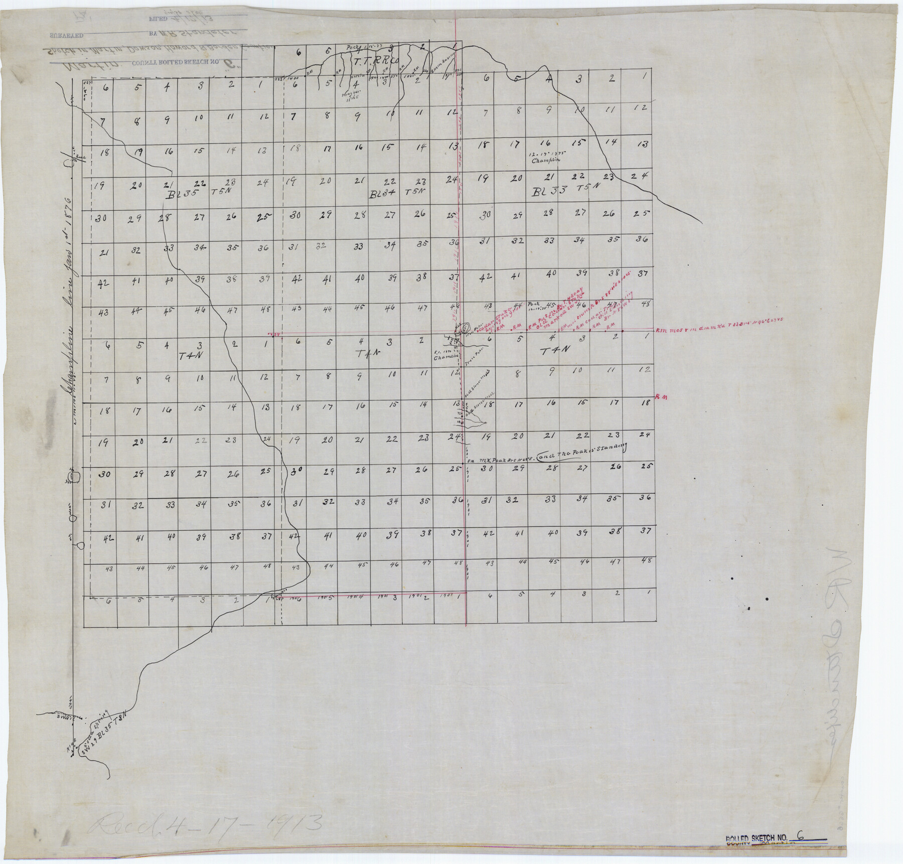
Martin County Rolled Sketch 6
[Sketch of Blocks 33, 34, and 35, Townships 4N and 5N in Dawson, Martin, and Borden Counties]
-
Map/Doc
6666
-
Collection
General Map Collection
-
Object Dates
1913/4/17 (File Date)
-
People and Organizations
W.R. Standefer (Surveyor/Engineer)
-
Counties
Martin Dawson Borden
-
Subjects
Surveying Rolled Sketch
-
Height x Width
25.8 x 26.9 inches
65.5 x 68.3 cm
-
Medium
linen, manuscript
Part of: General Map Collection
San Augustine County Sketch File 3

Print $10.00
San Augustine County Sketch File 3
1858
Size 11.8 x 8.1 inches
Map/Doc 35635
Taylor County Sketch File 19

Print $10.00
- Digital $50.00
Taylor County Sketch File 19
1945
Size 14.2 x 8.8 inches
Map/Doc 37816
[Sabine Pass]
![78263, [Sabine Pass], General Map Collection](https://historictexasmaps.com/wmedia_w700/maps/78263.tif.jpg)
Print $20.00
- Digital $50.00
[Sabine Pass]
1916
Size 29.2 x 42.1 inches
Map/Doc 78263
Map of Galveston East Bay and Bolivar Peninsular

Print $40.00
- Digital $50.00
Map of Galveston East Bay and Bolivar Peninsular
1851
Size 30.9 x 75.8 inches
Map/Doc 69919
No. 2 Chart of Corpus Christi Pass, Texas

Print $20.00
- Digital $50.00
No. 2 Chart of Corpus Christi Pass, Texas
1878
Size 18.4 x 27.3 inches
Map/Doc 73016
Pecos County Sketch File 21

Print $20.00
- Digital $50.00
Pecos County Sketch File 21
1886
Size 21.6 x 18.5 inches
Map/Doc 12161
Jeff Davis County Working Sketch 3

Print $20.00
- Digital $50.00
Jeff Davis County Working Sketch 3
1914
Size 17.8 x 16.9 inches
Map/Doc 66498
Coleman County Working Sketch 1

Print $20.00
- Digital $50.00
Coleman County Working Sketch 1
1900
Size 11.1 x 21.2 inches
Map/Doc 68067
St. Louis Southwestern Railway of Texas

Print $20.00
- Digital $50.00
St. Louis Southwestern Railway of Texas
1906
Size 22.6 x 30.3 inches
Map/Doc 64448
Comal County Sketch File 3

Print $8.00
- Digital $50.00
Comal County Sketch File 3
1853
Size 4.4 x 8.4 inches
Map/Doc 18999
La Salle County Working Sketch 40

Print $20.00
- Digital $50.00
La Salle County Working Sketch 40
1968
Size 23.0 x 19.2 inches
Map/Doc 70341
Kinney County Working Sketch 55

Print $20.00
- Digital $50.00
Kinney County Working Sketch 55
1982
Size 25.1 x 24.7 inches
Map/Doc 70237
You may also like
Howard County Sketch File 8

Print $3.00
- Digital $50.00
Howard County Sketch File 8
Size 20.8 x 18.7 inches
Map/Doc 11796
Ellis County Sketch File 19

Print $6.00
- Digital $50.00
Ellis County Sketch File 19
1863
Size 12.4 x 7.8 inches
Map/Doc 21866
Houston County Sketch File 4a

Print $4.00
- Digital $50.00
Houston County Sketch File 4a
1858
Size 13.0 x 8.3 inches
Map/Doc 26754
[Surveys in the Harris District at Clear Lake]
![276, [Surveys in the Harris District at Clear Lake], General Map Collection](https://historictexasmaps.com/wmedia_w700/maps/276-1.tif.jpg)
Print $2.00
- Digital $50.00
[Surveys in the Harris District at Clear Lake]
1840
Size 6.7 x 10.5 inches
Map/Doc 276
Swisher County Sketch File 3

Print $20.00
- Digital $50.00
Swisher County Sketch File 3
1896
Size 17.2 x 16.1 inches
Map/Doc 12403
[Sketch showing I. & G. N. Block 8]
![91798, [Sketch showing I. & G. N. Block 8], Twichell Survey Records](https://historictexasmaps.com/wmedia_w700/maps/91798-1.tif.jpg)
Print $2.00
- Digital $50.00
[Sketch showing I. & G. N. Block 8]
1919
Size 7.6 x 12.6 inches
Map/Doc 91798
Ward County Working Sketch 44

Print $40.00
- Digital $50.00
Ward County Working Sketch 44
1973
Size 50.8 x 34.6 inches
Map/Doc 72350
Roberts County Rolled Sketch 3

Print $40.00
- Digital $50.00
Roberts County Rolled Sketch 3
Size 37.7 x 48.9 inches
Map/Doc 8359
Copy of Surveyor's Field Book, Morris Browning - In Blocks 7, 5 & 4, I&GNRRCo., Hutchinson and Carson Counties, Texas

Print $2.00
- Digital $50.00
Copy of Surveyor's Field Book, Morris Browning - In Blocks 7, 5 & 4, I&GNRRCo., Hutchinson and Carson Counties, Texas
1888
Size 7.0 x 8.8 inches
Map/Doc 62284
Panola County Working Sketch 30

Print $20.00
- Digital $50.00
Panola County Working Sketch 30
1981
Map/Doc 71439
Gulf Intracoastal Waterway - Aransas Bay to Corpus Christi Bay - Modified Route Main Channel

Print $20.00
- Digital $50.00
Gulf Intracoastal Waterway - Aransas Bay to Corpus Christi Bay - Modified Route Main Channel
1960
Size 30.9 x 42.8 inches
Map/Doc 61900
Pecos County Rolled Sketch 29

Print $40.00
- Digital $50.00
Pecos County Rolled Sketch 29
1890
Size 27.3 x 49.9 inches
Map/Doc 9690