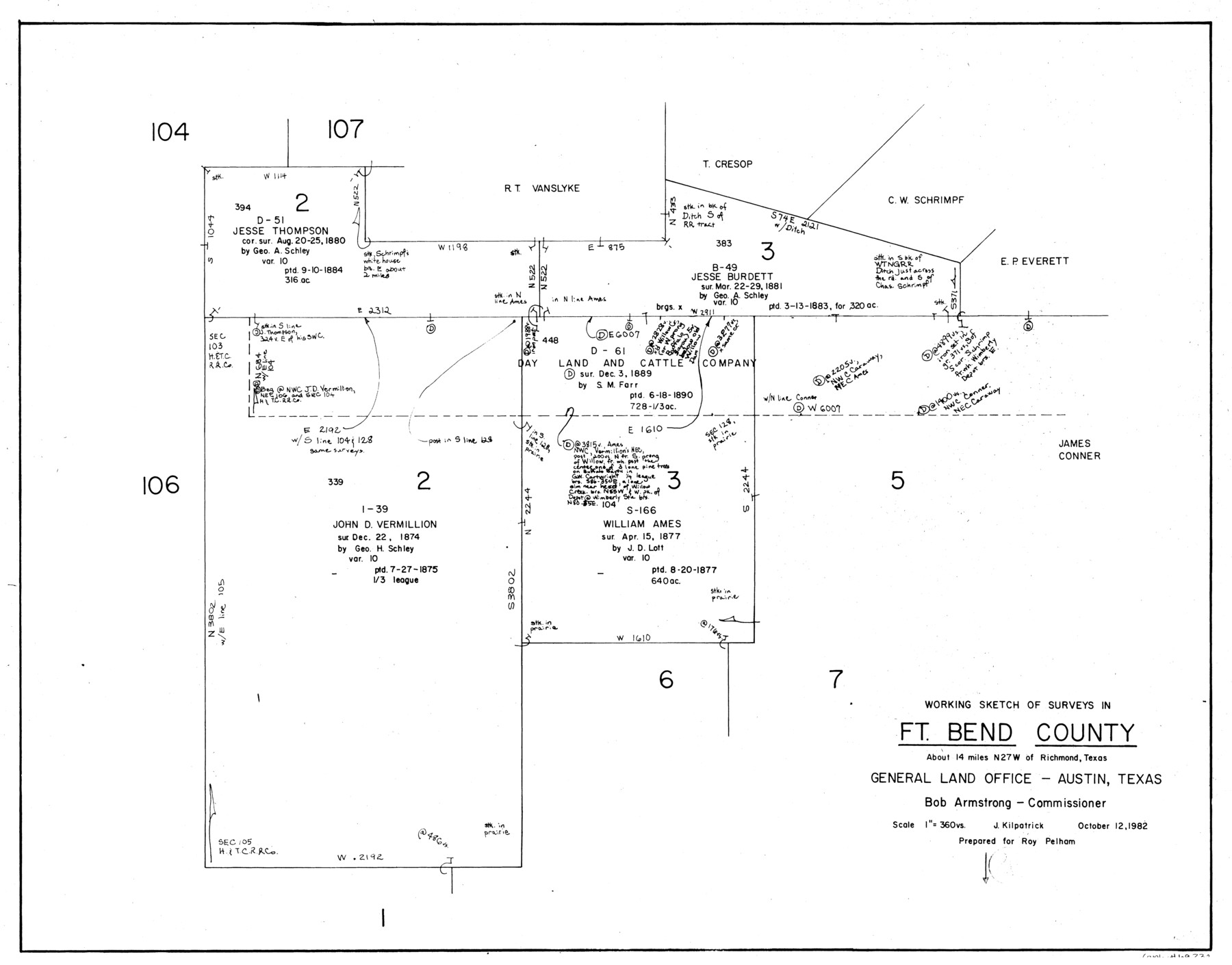
Fort Bend County Working Sketch 26
-
Map/Doc
69232
-
Collection
General Map Collection
-
Object Dates
10/12/1982 (Creation Date)
-
People and Organizations
Joan Kilpatrick (Draftsman)
-
Counties
Fort Bend
-
Subjects
Surveying Working Sketch
-
Height x Width
18.5 x 23.6 inches
47.0 x 59.9 cm
-
Scale
1" = 360 varas
Part of: General Map Collection
Bee County Working Sketch 11

Print $20.00
- Digital $50.00
Bee County Working Sketch 11
1942
Size 19.8 x 24.4 inches
Map/Doc 67261
Castro County Sketch File 18

Print $20.00
- Digital $50.00
Castro County Sketch File 18
1988
Size 40.4 x 37.7 inches
Map/Doc 10330
Map of Power and Hewetson Colony

Print $20.00
- Digital $50.00
Map of Power and Hewetson Colony
1841
Size 34.8 x 24.3 inches
Map/Doc 1950
Upton County Sketch File D

Print $12.00
- Digital $50.00
Upton County Sketch File D
Size 13.6 x 9.0 inches
Map/Doc 38854
Loving County Sketch File 10

Print $2.00
- Digital $50.00
Loving County Sketch File 10
2016
Size 11.0 x 8.5 inches
Map/Doc 94115
Kinney County Working Sketch 48

Print $40.00
- Digital $50.00
Kinney County Working Sketch 48
1979
Size 37.0 x 53.9 inches
Map/Doc 70230
Marion County Sketch File 10

Print $4.00
- Digital $50.00
Marion County Sketch File 10
1867
Size 7.9 x 12.4 inches
Map/Doc 30579
Hale County Working Sketch 8

Print $20.00
- Digital $50.00
Hale County Working Sketch 8
1982
Size 22.2 x 34.5 inches
Map/Doc 63328
Midland County Working Sketch 16

Print $40.00
- Digital $50.00
Midland County Working Sketch 16
1953
Size 61.7 x 32.6 inches
Map/Doc 70996
Pecos County Rolled Sketch 116

Print $20.00
- Digital $50.00
Pecos County Rolled Sketch 116
Size 26.7 x 20.6 inches
Map/Doc 7259
Kenedy County Rolled Sketch 8A

Print $20.00
- Digital $50.00
Kenedy County Rolled Sketch 8A
1915
Size 21.2 x 33.8 inches
Map/Doc 6465
Kent County Working Sketch 22

Print $20.00
- Digital $50.00
Kent County Working Sketch 22
1987
Size 42.7 x 43.1 inches
Map/Doc 70029
You may also like
[Lubbock County Block S and vicinity]
![91321, [Lubbock County Block S and vicinity], Twichell Survey Records](https://historictexasmaps.com/wmedia_w700/maps/91321-1.tif.jpg)
Print $20.00
- Digital $50.00
[Lubbock County Block S and vicinity]
Size 15.1 x 15.8 inches
Map/Doc 91321
Willie Winn Tract

Print $2.00
- Digital $50.00
Willie Winn Tract
1903
Size 5.9 x 7.6 inches
Map/Doc 92285
[Sketch for Mineral Application 26543 - Sabine River, D. H. Sanford]
![65678, [Sketch for Mineral Application 26543 - Sabine River, D. H. Sanford], General Map Collection](https://historictexasmaps.com/wmedia_w700/maps/65678.tif.jpg)
Print $40.00
- Digital $50.00
[Sketch for Mineral Application 26543 - Sabine River, D. H. Sanford]
1931
Size 73.0 x 30.3 inches
Map/Doc 65678
Houston County Sketch File 5a

Print $5.00
- Digital $50.00
Houston County Sketch File 5a
Size 8.5 x 9.4 inches
Map/Doc 26758
Map of Limestone County

Print $20.00
- Digital $50.00
Map of Limestone County
1877
Size 24.1 x 26.9 inches
Map/Doc 83012
Scurry County

Print $20.00
- Digital $50.00
Scurry County
1921
Size 42.4 x 39.1 inches
Map/Doc 95637
Kaufman County Working Sketch 9

Print $20.00
- Digital $50.00
Kaufman County Working Sketch 9
1988
Size 35.9 x 29.8 inches
Map/Doc 66672
Tom Green County Sketch File 60

Print $20.00
- Digital $50.00
Tom Green County Sketch File 60
1888
Size 28.4 x 25.9 inches
Map/Doc 12444
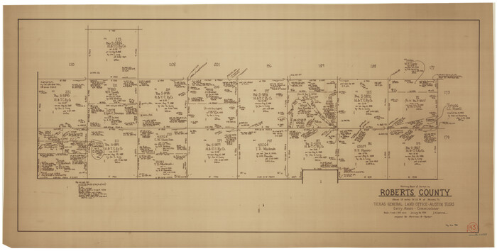
Roberts County Working Sketch 43
Print $20.00
- Digital $50.00
Roberts County Working Sketch 43
1990
Size 19.3 x 37.6 inches
Map/Doc 63569
Blanco County Working Sketch 1

Print $20.00
- Digital $50.00
Blanco County Working Sketch 1
Size 31.1 x 17.4 inches
Map/Doc 76449
Jack County Sketch File 15a

Print $6.00
- Digital $50.00
Jack County Sketch File 15a
1875
Size 14.7 x 10.2 inches
Map/Doc 27547
Flight Mission No. BQY-4M, Frame 42, Harris County

Print $20.00
- Digital $50.00
Flight Mission No. BQY-4M, Frame 42, Harris County
1953
Size 18.7 x 22.4 inches
Map/Doc 85257