Kenedy County Rolled Sketch 8A
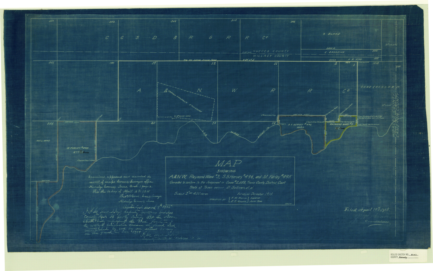
Map showing A. & N. W., Raymond Word #3, S.S. Hervey #496, and M. Farley #495 corrected to conform to the Judgement in Cause #2888, Travis County District Court, State of Texas versus D. Sullivan, et al.
-
Map/Doc
6465
-
Collection
General Map Collection
-
Object Dates
3/2/1915 (Creation Date)
4/15/1915 (File Date)
12/1914 (Survey Date)
-
People and Organizations
E.F. Maddox (Surveyor/Engineer)
F.M. Maddox (Surveyor/Engineer)
-
Counties
Kenedy
-
Subjects
Surveying Rolled Sketch
-
Height x Width
21.2 x 33.8 inches
53.9 x 85.9 cm
-
Medium
blueprint/diazo
-
Scale
1" = 400 varas
Part of: General Map Collection
La Salle County Sketch File 28a

Print $6.00
- Digital $50.00
La Salle County Sketch File 28a
1898
Size 4.5 x 5.2 inches
Map/Doc 29558
Flight Mission No. CUG-1P, Frame 167, Kleberg County

Print $20.00
- Digital $50.00
Flight Mission No. CUG-1P, Frame 167, Kleberg County
1956
Size 18.7 x 22.4 inches
Map/Doc 86174
Liberty County Rolled Sketch JP2

Print $40.00
- Digital $50.00
Liberty County Rolled Sketch JP2
1935
Size 52.2 x 12.7 inches
Map/Doc 81403
Jeff Davis County Sketch File 8

Print $20.00
- Digital $50.00
Jeff Davis County Sketch File 8
1889
Size 19.5 x 28.5 inches
Map/Doc 11857
Port Aransas-Corpus Christi Waterway, Texas, Avery Point Turning Basin to Vicinity of Tule Lake - Dredging

Print $20.00
- Digital $50.00
Port Aransas-Corpus Christi Waterway, Texas, Avery Point Turning Basin to Vicinity of Tule Lake - Dredging
1947
Size 28.6 x 41.8 inches
Map/Doc 1996
Loving County Rolled Sketch 17

Print $40.00
- Digital $50.00
Loving County Rolled Sketch 17
2022
Size 38.2 x 49.3 inches
Map/Doc 97292
Kimble County Sketch File 26

Print $4.00
- Digital $50.00
Kimble County Sketch File 26
1912
Size 7.8 x 13.0 inches
Map/Doc 28969
Tyler County Sketch File 18

Print $4.00
- Digital $50.00
Tyler County Sketch File 18
1879
Size 8.2 x 8.7 inches
Map/Doc 38668
Cottle County Rolled Sketch 5

Print $20.00
- Digital $50.00
Cottle County Rolled Sketch 5
1911
Size 31.0 x 41.1 inches
Map/Doc 8672
Flight Mission No. DQN-3K, Frame 75, Calhoun County

Print $20.00
- Digital $50.00
Flight Mission No. DQN-3K, Frame 75, Calhoun County
1953
Size 18.6 x 22.4 inches
Map/Doc 84366
Map of the Western Part of Bexar District

Print $40.00
- Digital $50.00
Map of the Western Part of Bexar District
1849
Size 64.0 x 54.3 inches
Map/Doc 16944
Working Sketch, Goliad & Bee Counties

Print $20.00
- Digital $50.00
Working Sketch, Goliad & Bee Counties
1936
Size 35.0 x 43.1 inches
Map/Doc 2453
You may also like
[Eastern part of Culberson County]
![90505, [Eastern part of Culberson County], Twichell Survey Records](https://historictexasmaps.com/wmedia_w700/maps/90505-1.tif.jpg)
Print $20.00
- Digital $50.00
[Eastern part of Culberson County]
Size 29.0 x 40.5 inches
Map/Doc 90505
General Highway Map. Detail of Cities and Towns in Smith County, Texas. City Map, Tyler and vicinity, Smith County, Texas

Print $20.00
General Highway Map. Detail of Cities and Towns in Smith County, Texas. City Map, Tyler and vicinity, Smith County, Texas
1961
Size 18.2 x 24.9 inches
Map/Doc 79657
Coke County Rolled Sketch 14C

Print $20.00
- Digital $50.00
Coke County Rolled Sketch 14C
Size 25.8 x 18.4 inches
Map/Doc 5517
Webb County Working Sketch 48

Print $20.00
- Digital $50.00
Webb County Working Sketch 48
1948
Size 28.5 x 41.4 inches
Map/Doc 72413
Fractional Township No. 8 South Range No. 15 East of the Indian Meridian, Indian Territory

Print $20.00
- Digital $50.00
Fractional Township No. 8 South Range No. 15 East of the Indian Meridian, Indian Territory
1896
Size 19.1 x 24.3 inches
Map/Doc 75227
General Highway Map, Colorado County, Texas

Print $20.00
General Highway Map, Colorado County, Texas
1961
Size 25.1 x 18.3 inches
Map/Doc 79416
Topographical Map of the Rio Grande, Sheet No. 5

Print $20.00
- Digital $50.00
Topographical Map of the Rio Grande, Sheet No. 5
1912
Map/Doc 89529
This is a sketch of Austin town tract

Print $2.00
- Digital $50.00
This is a sketch of Austin town tract
Size 6.5 x 8.1 inches
Map/Doc 148
Zavala County Rolled Sketch 33

Print $20.00
- Digital $50.00
Zavala County Rolled Sketch 33
Size 19.3 x 26.9 inches
Map/Doc 8334

El Paso County Rolled Sketch 52

Print $20.00
- Digital $50.00
El Paso County Rolled Sketch 52
1929
Size 18.4 x 24.3 inches
Map/Doc 5839
Aransas Migratory Waterfowl Refuge, San Antonio Loan & Trust Company Tracts, 45,596.98 acres, Aransas and Refugio Counties

Print $20.00
- Digital $50.00
Aransas Migratory Waterfowl Refuge, San Antonio Loan & Trust Company Tracts, 45,596.98 acres, Aransas and Refugio Counties
1937
Size 41.1 x 30.8 inches
Map/Doc 3073