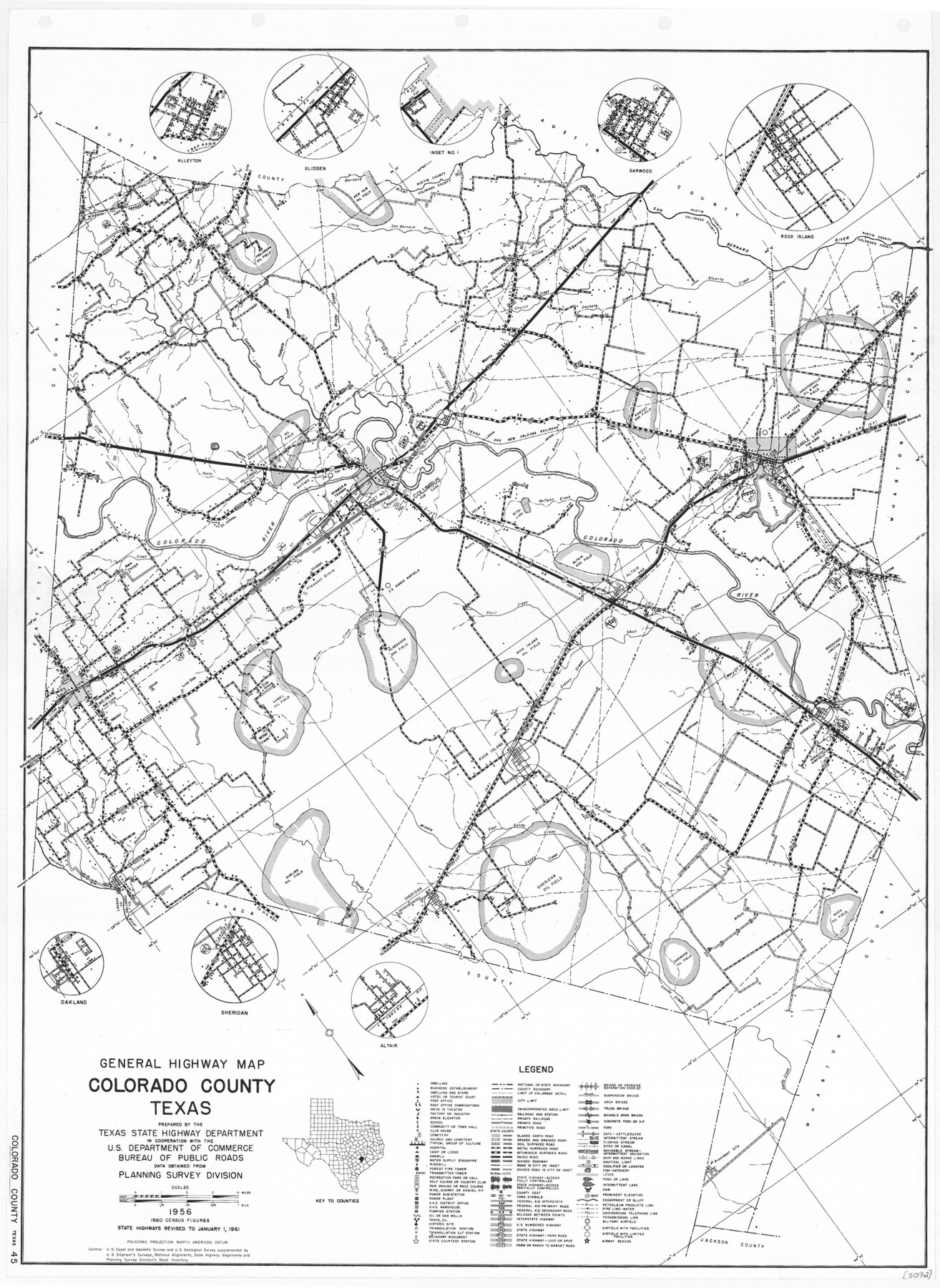
General Highway Map, Colorado County, Texas
-
Map/Doc
79416
-
Collection
Texas State Library and Archives
-
Object Dates
1961 (Creation Date)
-
People and Organizations
Texas State Highway Department (Publisher)
-
Counties
Colorado
-
Subjects
County
-
Height x Width
25.1 x 18.3 inches
63.8 x 46.5 cm
-
Comments
Prints available courtesy of the Texas State Library and Archives.
More info can be found here: TSLAC Map 05092
Part of: Texas State Library and Archives
General Highway Map, Grayson County, Texas

Print $20.00
General Highway Map, Grayson County, Texas
1940
Size 24.9 x 18.4 inches
Map/Doc 79104
General Highway Map, Frio County, Texas

Print $20.00
General Highway Map, Frio County, Texas
1940
Size 18.4 x 24.9 inches
Map/Doc 79095
General Highway Map, Kerr County, Texas

Print $20.00
General Highway Map, Kerr County, Texas
1961
Size 24.8 x 18.2 inches
Map/Doc 79551
A.R. Roessler's Latest Map of the State of Texas Exhibiting Mineral and Agricultural Districts, Post Offices and Mailroutes, Railroads projected and finished, Timber, Prairie, Swamp Lands, etc. etc. etc.

Print $20.00
A.R. Roessler's Latest Map of the State of Texas Exhibiting Mineral and Agricultural Districts, Post Offices and Mailroutes, Railroads projected and finished, Timber, Prairie, Swamp Lands, etc. etc. etc.
1874
Size 39.7 x 46.8 inches
Map/Doc 76254
General Highway Map, Montgomery County, Texas

Print $20.00
General Highway Map, Montgomery County, Texas
1961
Size 18.2 x 24.6 inches
Map/Doc 79602
General Highway Map, Tom Green County, Texas

Print $20.00
General Highway Map, Tom Green County, Texas
1961
Size 18.4 x 25.0 inches
Map/Doc 79678
General Highway Map, Motley County, Texas

Print $20.00
General Highway Map, Motley County, Texas
1940
Size 24.5 x 18.2 inches
Map/Doc 79204
United States Including California, Texas, and c.

Print $20.00
United States Including California, Texas, and c.
1861
Size 21.4 x 25.7 inches
Map/Doc 76238
General Highway Map. Detail of Cities and Towns in Harris County, Texas. City Map [of] Baytown, Morgan's Point, Lomax, and vicinity, Harris County, Texas
![79508, General Highway Map. Detail of Cities and Towns in Harris County, Texas. City Map [of] Baytown, Morgan's Point, Lomax, and vicinity, Harris County, Texas, Texas State Library and Archives](https://historictexasmaps.com/wmedia_w700/maps/79508.tif.jpg)
Print $20.00
General Highway Map. Detail of Cities and Towns in Harris County, Texas. City Map [of] Baytown, Morgan's Point, Lomax, and vicinity, Harris County, Texas
1961
Size 18.2 x 24.5 inches
Map/Doc 79508
General Highway Map, Eastland County, Texas

Print $20.00
General Highway Map, Eastland County, Texas
1940
Size 18.1 x 24.8 inches
Map/Doc 79080
Map of Texas. The Proposed Reoccupation of the Rio Grande -- Its Importance to the Union

Print $20.00
Map of Texas. The Proposed Reoccupation of the Rio Grande -- Its Importance to the Union
1965
Size 14.1 x 8.6 inches
Map/Doc 76264
General Highway Map, Hartley County, Texas

Print $20.00
General Highway Map, Hartley County, Texas
1961
Size 24.4 x 18.0 inches
Map/Doc 79511
You may also like
Hockley County Sketch, Mineral Application Number 39180

Print $3.00
- Digital $50.00
Hockley County Sketch, Mineral Application Number 39180
1947
Size 10.4 x 12.8 inches
Map/Doc 91106
Shelby County Rolled Sketch 16

Print $20.00
- Digital $50.00
Shelby County Rolled Sketch 16
1935
Size 33.0 x 43.8 inches
Map/Doc 9925
Edwards County Boundary File 29

Print $22.00
- Digital $50.00
Edwards County Boundary File 29
Size 15.4 x 31.0 inches
Map/Doc 65502
La Salle County Working Sketch 44

Print $40.00
- Digital $50.00
La Salle County Working Sketch 44
1980
Size 34.7 x 65.8 inches
Map/Doc 70345
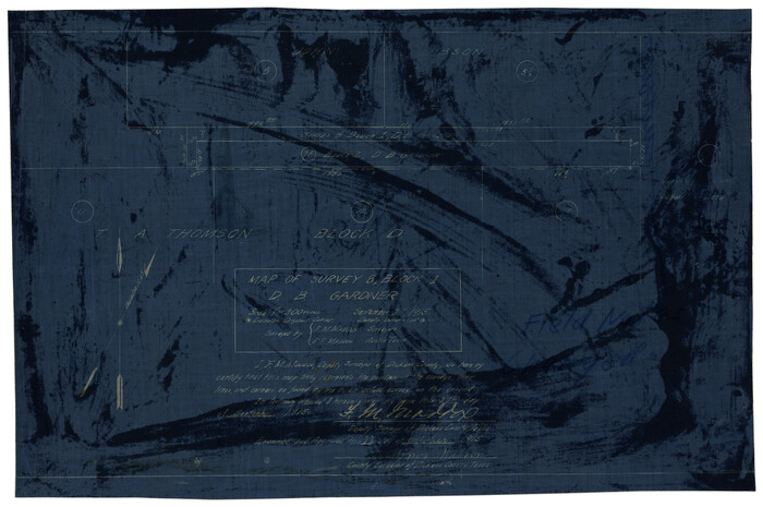
Map of Survey 8, Block 1, D.B. Gardner
Print $20.00
- Digital $50.00
Map of Survey 8, Block 1, D.B. Gardner
1915
Size 13.0 x 18.8 inches
Map/Doc 10763
Medina County Working Sketch 5

Print $20.00
- Digital $50.00
Medina County Working Sketch 5
1949
Size 38.5 x 37.3 inches
Map/Doc 70920
Brewster County Sketch File N-16

Print $16.00
- Digital $50.00
Brewster County Sketch File N-16
1922
Size 6.2 x 8.7 inches
Map/Doc 15643
Travis County Working Sketch 47

Print $40.00
- Digital $50.00
Travis County Working Sketch 47
1981
Size 55.5 x 41.8 inches
Map/Doc 69431
Travis County Working Sketch 17

Print $20.00
- Digital $50.00
Travis County Working Sketch 17
1944
Size 27.8 x 23.3 inches
Map/Doc 69401
Map showing lines of march and border patrols, in my Mexican Border Service, 1916-1917

Print $20.00
- Digital $50.00
Map showing lines of march and border patrols, in my Mexican Border Service, 1916-1917
1916
Size 18.7 x 41.7 inches
Map/Doc 95822

[Gulf, Colorado & Santa Fe]
![64573, [Gulf, Colorado & Santa Fe], General Map Collection](https://historictexasmaps.com/wmedia_w700/maps/64573-1.tif.jpg)
Print $40.00
- Digital $50.00
[Gulf, Colorado & Santa Fe]
Size 32.5 x 122.6 inches
Map/Doc 64573