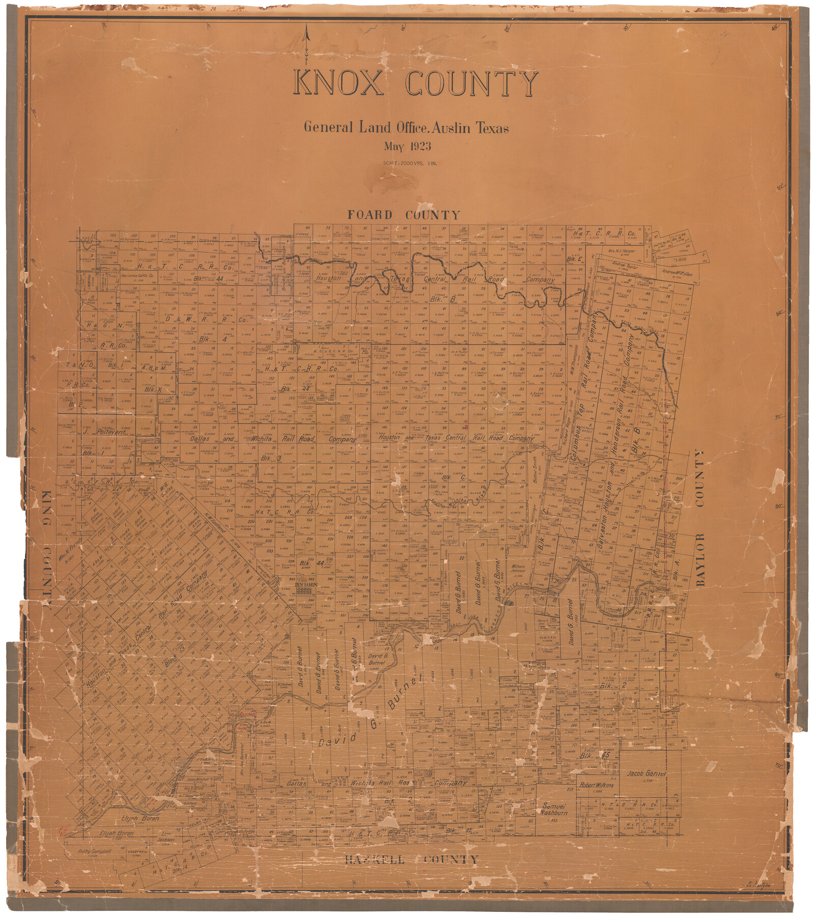
Knox County
-
Map/Doc
73211
-
Collection
General Map Collection
-
Object Dates
1923 (Creation Date)
-
People and Organizations
Texas General Land Office (Publisher)
Fr. Matzow (Draftsman)
-
Counties
Knox
-
Subjects
County
-
Height x Width
44.1 x 39.7 inches
112.0 x 100.8 cm
-
Comments
Hand lettered.
-
Features
North Wichita River
Kiowa Creek
Ranger Creek
South Wichita River
Salt Fork of Brazos River
Benjamin
WVRR
Part of: General Map Collection
Wise County Working Sketch 27

Print $20.00
- Digital $50.00
Wise County Working Sketch 27
1988
Size 28.0 x 37.2 inches
Map/Doc 72641
Fisher County Working Sketch 20

Print $20.00
- Digital $50.00
Fisher County Working Sketch 20
1993
Size 38.1 x 26.6 inches
Map/Doc 69154
Nolan County Sketch File C

Print $20.00
- Digital $50.00
Nolan County Sketch File C
1902
Size 14.4 x 31.5 inches
Map/Doc 42172
Bastrop County Sketch File 3

Print $4.00
- Digital $50.00
Bastrop County Sketch File 3
1860
Size 8.9 x 9.2 inches
Map/Doc 14044
Duval County Rolled Sketch 33A

Print $40.00
- Digital $50.00
Duval County Rolled Sketch 33A
1949
Size 43.8 x 79.5 inches
Map/Doc 8818
The State of Oklahoma

Print $20.00
- Digital $50.00
The State of Oklahoma
1916
Size 28.4 x 34.4 inches
Map/Doc 97104
Eastland County Working Sketch 66

Print $20.00
- Digital $50.00
Eastland County Working Sketch 66
2014
Size 27.2 x 20.1 inches
Map/Doc 93708
Flight Mission No. BQY-15M, Frame 15, Harris County

Print $20.00
- Digital $50.00
Flight Mission No. BQY-15M, Frame 15, Harris County
1953
Size 18.6 x 22.4 inches
Map/Doc 85313
Flight Mission No. BRA-16M, Frame 54, Jefferson County

Print $20.00
- Digital $50.00
Flight Mission No. BRA-16M, Frame 54, Jefferson County
1953
Size 18.5 x 22.5 inches
Map/Doc 85671
Live Oak County Sketch File 26

Print $6.00
- Digital $50.00
Live Oak County Sketch File 26
1922
Size 7.1 x 8.6 inches
Map/Doc 30309
Lubbock County Sketch File 13

Print $20.00
- Digital $50.00
Lubbock County Sketch File 13
1952
Size 20.4 x 14.5 inches
Map/Doc 12018
Jefferson County Sketch File 25

Print $14.00
- Digital $50.00
Jefferson County Sketch File 25
1896
Size 7.6 x 6.7 inches
Map/Doc 28184
You may also like
Brewster County Working Sketch 51

Print $40.00
- Digital $50.00
Brewster County Working Sketch 51
1950
Size 62.9 x 26.4 inches
Map/Doc 67585
Childress County

Print $20.00
- Digital $50.00
Childress County
1921
Size 43.4 x 32.3 inches
Map/Doc 1800
Atlas B, 1-137, Burnet's Colony

Atlas B, 1-137, Burnet's Colony
Size 13.2 x 18.1 inches
Map/Doc 94537
Presidio County Sketch File 50

Print $8.00
- Digital $50.00
Presidio County Sketch File 50
1919
Size 13.3 x 8.8 inches
Map/Doc 34586
Hudspeth County Rolled Sketch 43A

Print $3.00
- Digital $50.00
Hudspeth County Rolled Sketch 43A
1958
Size 10.7 x 8.8 inches
Map/Doc 6252
Presidio County Rolled Sketch 58

Print $20.00
- Digital $50.00
Presidio County Rolled Sketch 58
Size 26.1 x 36.6 inches
Map/Doc 7351
[Capitol Leagues 217-239]
![90668, [Capitol Leagues 217-239], Twichell Survey Records](https://historictexasmaps.com/wmedia_w700/maps/90668-1.tif.jpg)
Print $20.00
- Digital $50.00
[Capitol Leagues 217-239]
Size 26.9 x 26.6 inches
Map/Doc 90668
Flight Mission No. DQN-2K, Frame 69, Calhoun County

Print $20.00
- Digital $50.00
Flight Mission No. DQN-2K, Frame 69, Calhoun County
1953
Size 16.2 x 16.1 inches
Map/Doc 84261
Travis County Boundary File 6

Print $109.00
- Digital $50.00
Travis County Boundary File 6
Size 14.6 x 9.1 inches
Map/Doc 59433
Williamson County Working Sketch 10

Print $20.00
- Digital $50.00
Williamson County Working Sketch 10
1961
Size 31.1 x 20.0 inches
Map/Doc 72570
Flight Mission No. CUG-3P, Frame 192, Kleberg County

Print $20.00
- Digital $50.00
Flight Mission No. CUG-3P, Frame 192, Kleberg County
1956
Size 18.4 x 22.2 inches
Map/Doc 86296
Trinity County Sketch File 13

Print $6.00
- Digital $50.00
Trinity County Sketch File 13
1857
Size 5.0 x 6.3 inches
Map/Doc 38537