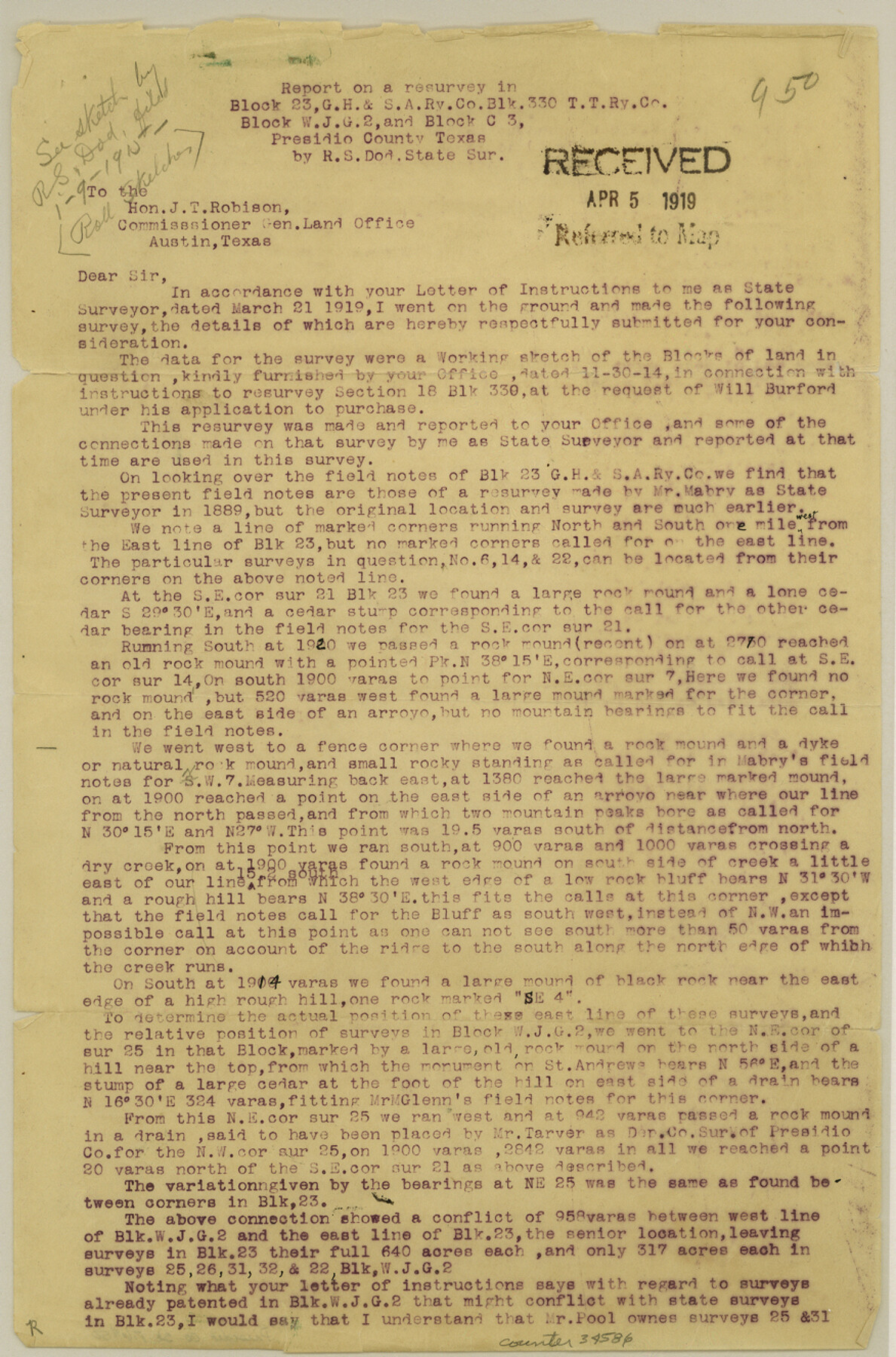
Presidio County Sketch File 50
[Report on a resurvey in Block 23, G. H. & S. A. RR. Co., Block 330, T. T. RR. Co., Block WJG2 and Block C3]
-
Map/Doc
34586
-
Collection
General Map Collection
-
Object Dates
4/3/1919 (Creation Date)
4/5/1919 (File Date)
12/1914 (Survey Date)
-
People and Organizations
R.S. Dod (Surveyor/Engineer)
W.S. Mabry (Surveyor/Engineer)
H.B. Tarver (Surveyor/Engineer)
S.A. Thompson (Surveyor/Engineer)
-
Counties
Presidio
-
Subjects
Surveying Sketch File
-
Height x Width
13.3 x 8.8 inches
33.8 x 22.4 cm
-
Medium
paper, print
-
Features
Las Moras Creek
Cibolo Creek
Part of: General Map Collection
Flight Mission No. CUG-2P, Frame 59, Kleberg County

Print $20.00
- Digital $50.00
Flight Mission No. CUG-2P, Frame 59, Kleberg County
1956
Size 18.4 x 22.1 inches
Map/Doc 86196
Rusk County Sketch File 40

Print $20.00
Rusk County Sketch File 40
1951
Size 23.2 x 26.6 inches
Map/Doc 12276

Brooks County Sketch File 10

Print $2.00
- Digital $50.00
Brooks County Sketch File 10
1988
Size 14.4 x 9.0 inches
Map/Doc 16572
Crockett County Sketch File 38

Print $20.00
- Digital $50.00
Crockett County Sketch File 38
1887
Size 20.8 x 30.3 inches
Map/Doc 11220
Chicago, Rock Island, Texas & Mexico

Print $20.00
- Digital $50.00
Chicago, Rock Island, Texas & Mexico
1920
Size 23.9 x 13.8 inches
Map/Doc 64423
Real County Sketch File 6

Print $20.00
- Digital $50.00
Real County Sketch File 6
1931
Size 17.3 x 19.6 inches
Map/Doc 12229
Navarro County Working Sketch 1c

Print $2.00
- Digital $50.00
Navarro County Working Sketch 1c
Size 7.1 x 10.6 inches
Map/Doc 71231
Flight Mission No. CLL-1N, Frame 192, Willacy County

Print $20.00
- Digital $50.00
Flight Mission No. CLL-1N, Frame 192, Willacy County
1954
Size 18.5 x 22.2 inches
Map/Doc 87062
Presidio County Rolled Sketch 69

Print $20.00
- Digital $50.00
Presidio County Rolled Sketch 69
1927
Size 36.5 x 14.1 inches
Map/Doc 7359
Harris County Working Sketch 27

Print $20.00
- Digital $50.00
Harris County Working Sketch 27
1933
Size 36.9 x 43.0 inches
Map/Doc 65919
Uvalde County Rolled Sketch 17

Print $20.00
- Digital $50.00
Uvalde County Rolled Sketch 17
Size 26.7 x 22.2 inches
Map/Doc 8101
You may also like
[Liberty County, Texas]
![60297, [Liberty County, Texas], General Map Collection](https://historictexasmaps.com/wmedia_w700/maps/60297-1.tif.jpg)
Print $20.00
- Digital $50.00
[Liberty County, Texas]
1890
Size 24.2 x 16.9 inches
Map/Doc 60297
Corpus Christi Pass, Texas

Print $20.00
- Digital $50.00
Corpus Christi Pass, Texas
1869
Size 24.3 x 18.2 inches
Map/Doc 72965
Maps of Gulf Intracoastal Waterway, Texas - Sabine River to the Rio Grande and connecting waterways including ship channels

Print $20.00
- Digital $50.00
Maps of Gulf Intracoastal Waterway, Texas - Sabine River to the Rio Grande and connecting waterways including ship channels
1966
Size 14.6 x 22.2 inches
Map/Doc 61947
Bird's Eye View of Schulenburg, Fayette County, Texas

Print $20.00
Bird's Eye View of Schulenburg, Fayette County, Texas
1881
Size 18.6 x 31.0 inches
Map/Doc 89206
Medina County Working Sketch 20

Print $20.00
- Digital $50.00
Medina County Working Sketch 20
1980
Size 25.4 x 39.2 inches
Map/Doc 70935
Van Zandt County Sketch File 49

Print $2.00
- Digital $50.00
Van Zandt County Sketch File 49
1990
Size 11.3 x 8.9 inches
Map/Doc 39510
Hutchinson County Sketch File 25

Print $6.00
- Digital $50.00
Hutchinson County Sketch File 25
1922
Size 11.2 x 8.8 inches
Map/Doc 27258
Tyler County Working Sketch 18

Print $20.00
- Digital $50.00
Tyler County Working Sketch 18
1965
Size 31.4 x 27.3 inches
Map/Doc 69488

[Gulf Colorado & Santa Fe from 2178+36.0 to 3901+06.2]
![64695, [Gulf Colorado & Santa Fe from 2178+36.0 to 3901+06.2], General Map Collection](https://historictexasmaps.com/wmedia_w700/maps/64695-1.tif.jpg)
Print $40.00
- Digital $50.00
[Gulf Colorado & Santa Fe from 2178+36.0 to 3901+06.2]
Size 33.6 x 120.7 inches
Map/Doc 64695
Menard County Working Sketch 22

Print $20.00
- Digital $50.00
Menard County Working Sketch 22
1950
Size 31.7 x 38.7 inches
Map/Doc 70969
Intracoastal Waterway in Texas - Corpus Christi to Point Isabel including Arroyo Colorado to Mo. Pac. R.R. Bridge Near Harlingen

Print $20.00
- Digital $50.00
Intracoastal Waterway in Texas - Corpus Christi to Point Isabel including Arroyo Colorado to Mo. Pac. R.R. Bridge Near Harlingen
1934
Size 22.1 x 32.7 inches
Map/Doc 61887