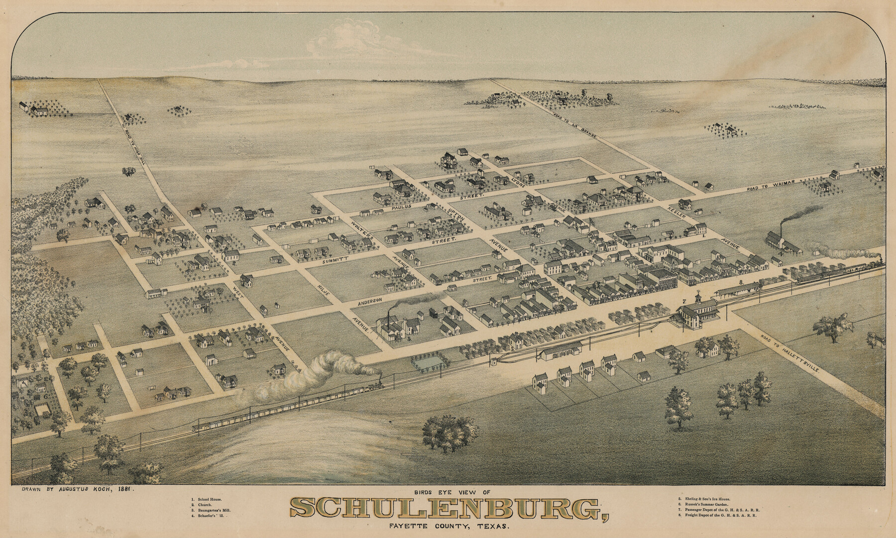
Bird's Eye View of Schulenburg, Fayette County, Texas
-
Map/Doc
89206
-
Collection
Non-GLO Digital Images
-
Object Dates
1881 (Creation Date)
-
People and Organizations
Augustus Koch (Draftsman)
-
Counties
Fayette
-
Subjects
Bird's Eye View City Pictorial
-
Height x Width
18.6 x 31.0 inches
47.2 x 78.7 cm
-
Comments
Bird's Eye View map. Public Domain image obtained from Wikimedia Commons.
Part of: Non-GLO Digital Images
Ladonia, Fannin County, Texas

Print $20.00
Ladonia, Fannin County, Texas
1891
Size 12.0 x 22.1 inches
Map/Doc 89097
Engineer map showing engineer information at 23 O'Clock 23 Oct. 1918 drawn under direction of Col. W.A. Mitchell

Print $20.00
Engineer map showing engineer information at 23 O'Clock 23 Oct. 1918 drawn under direction of Col. W.A. Mitchell
1918
Size 19.6 x 12.5 inches
Map/Doc 94127
County Map of Texas, and Indian Territory

Print $20.00
County Map of Texas, and Indian Territory
1872
Size 18.9 x 16.1 inches
Map/Doc 88820
[Movements & Objectives of the 143rd & 144th Infantry on October 12-13, 1918] - Verso
![94136, [Movements & Objectives of the 143rd & 144th Infantry on October 12-13, 1918] - Verso, Non-GLO Digital Images](https://historictexasmaps.com/wmedia_w700/maps/94136-1.tif.jpg)
Print $20.00
[Movements & Objectives of the 143rd & 144th Infantry on October 12-13, 1918] - Verso
1918
Size 42.4 x 30.0 inches
Map/Doc 94136

Mapa del Ferro-Carril del Rio Grande, Condado de Cameron Texas

Mapa del Ferro-Carril del Rio Grande, Condado de Cameron Texas
Size 18.4 x 72.5 inches
Map/Doc 94564
J. De Cordova's Map of the State of Texas Compiled from the records of the General Land Office of the State

Print $20.00
J. De Cordova's Map of the State of Texas Compiled from the records of the General Land Office of the State
1849
Size 35.7 x 33.6 inches
Map/Doc 93964
Rain Chart of the United States showing by isohyetal lines the distribution of the mean annual precipitation in rain and melted snow

Print $20.00
Rain Chart of the United States showing by isohyetal lines the distribution of the mean annual precipitation in rain and melted snow
1878
Size 20.8 x 29.4 inches
Map/Doc 95190


Plano de la Villa y Presidio de S. Antonio de Vejar situado en la Provincia de Tejas en 29 grad. y 52 minutos de latitud bor. y 275° y 57' de long. contados desde de Meridiano d. Tenerife

Plano de la Villa y Presidio de S. Antonio de Vejar situado en la Provincia de Tejas en 29 grad. y 52 minutos de latitud bor. y 275° y 57' de long. contados desde de Meridiano d. Tenerife
1768
Size 16.8 x 21.2 inches
Map/Doc 96564
Bird's Eye View of the City of Belton, Bell County, Texas

Print $20.00
Bird's Eye View of the City of Belton, Bell County, Texas
1881
Size 18.5 x 23.8 inches
Map/Doc 89074
You may also like
[Surveys in the Travis District along the Colorado River]
![120, [Surveys in the Travis District along the Colorado River], General Map Collection](https://historictexasmaps.com/wmedia_w700/maps/120-2.tif.jpg)
Print $3.00
- Digital $50.00
[Surveys in the Travis District along the Colorado River]
1841
Size 7.0 x 16.5 inches
Map/Doc 120
[Township 5-S, Blocks 36, 37 & 38]
![92292, [Township 5-S, Blocks 36, 37 & 38], Twichell Survey Records](https://historictexasmaps.com/wmedia_w700/maps/92292-1.tif.jpg)
Print $20.00
- Digital $50.00
[Township 5-S, Blocks 36, 37 & 38]
1952
Size 27.7 x 26.6 inches
Map/Doc 92292
King County Working Sketch 8

Print $20.00
- Digital $50.00
King County Working Sketch 8
1955
Size 30.8 x 24.8 inches
Map/Doc 70172
Harrison County Sketch File 7

Print $6.00
- Digital $50.00
Harrison County Sketch File 7
1858
Size 11.7 x 9.7 inches
Map/Doc 26046
Upshur County Working Sketch 2

Print $20.00
- Digital $50.00
Upshur County Working Sketch 2
1934
Size 16.3 x 21.4 inches
Map/Doc 69558
Real County Rolled Sketch 18

Print $20.00
- Digital $50.00
Real County Rolled Sketch 18
Size 22.0 x 28.0 inches
Map/Doc 7466
Gregg County Working Sketch 16

Print $20.00
- Digital $50.00
Gregg County Working Sketch 16
1944
Size 14.8 x 27.9 inches
Map/Doc 63283
Edwards County Sketch File 1

Print $10.00
- Digital $50.00
Edwards County Sketch File 1
Size 9.2 x 7.0 inches
Map/Doc 21672
United States - Gulf Coast Texas - Northern part of Laguna Madre

Print $20.00
- Digital $50.00
United States - Gulf Coast Texas - Northern part of Laguna Madre
1941
Size 26.9 x 18.3 inches
Map/Doc 72938
Brazoria County Sketch File 59

Print $364.00
- Digital $50.00
Brazoria County Sketch File 59
1996
Size 14.9 x 8.3 inches
Map/Doc 15398
Atascosa County Working Sketch 21

Print $20.00
- Digital $50.00
Atascosa County Working Sketch 21
1954
Size 26.0 x 22.4 inches
Map/Doc 67217
Harris County Working Sketch 4

Print $20.00
- Digital $50.00
Harris County Working Sketch 4
Size 20.7 x 26.6 inches
Map/Doc 65896