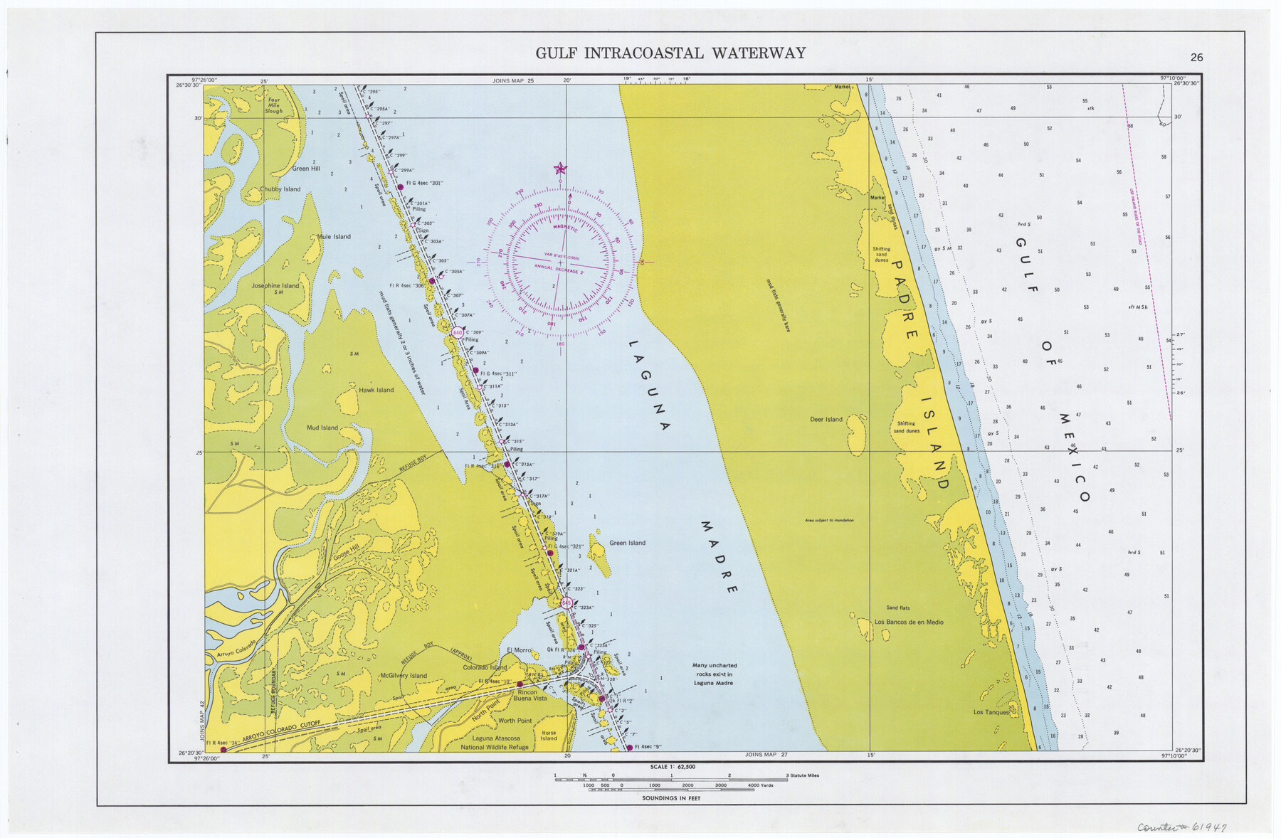
Maps of Gulf Intracoastal Waterway, Texas - Sabine River to the Rio Grande and connecting waterways including ship channels
-
Map/Doc
61947
-
Collection
General Map Collection
-
Object Dates
1966 (Creation Date)
-
Subjects
Intracoastal Waterways
-
Height x Width
14.6 x 22.2 inches
37.1 x 56.4 cm
Part of: General Map Collection
Map of Mills Co.

Print $20.00
- Digital $50.00
Map of Mills Co.
1887
Size 32.7 x 41.1 inches
Map/Doc 78439
Presidio County Rolled Sketch 57

Print $20.00
- Digital $50.00
Presidio County Rolled Sketch 57
1915
Size 22.8 x 17.3 inches
Map/Doc 7350
Rockwall County Sketch File 9

Print $20.00
Rockwall County Sketch File 9
Size 31.1 x 39.7 inches
Map/Doc 10590
Matagorda County

Print $40.00
- Digital $50.00
Matagorda County
1920
Size 39.7 x 49.1 inches
Map/Doc 77368
El Paso Street and Vicinity Map (Verso)

El Paso Street and Vicinity Map (Verso)
1962
Size 18.3 x 30.8 inches
Map/Doc 94176
Lavaca County Boundary File 58

Print $20.00
- Digital $50.00
Lavaca County Boundary File 58
Size 8.5 x 7.1 inches
Map/Doc 56259
Reagan County Rolled Sketch 4

Print $20.00
- Digital $50.00
Reagan County Rolled Sketch 4
1928
Size 25.4 x 27.4 inches
Map/Doc 7433

Pecos County Rolled Sketch 165

Print $20.00
- Digital $50.00
Pecos County Rolled Sketch 165
1966
Size 19.0 x 15.9 inches
Map/Doc 7288
Irion County Sketch File 18

Print $10.00
- Digital $50.00
Irion County Sketch File 18
Size 11.2 x 8.7 inches
Map/Doc 27494
Flight Mission No. DIX-10P, Frame 174, Aransas County

Print $20.00
- Digital $50.00
Flight Mission No. DIX-10P, Frame 174, Aransas County
1956
Size 18.5 x 22.2 inches
Map/Doc 83964
Goliad County Sketch File 11

Print $40.00
- Digital $50.00
Goliad County Sketch File 11
Size 13.4 x 12.5 inches
Map/Doc 24228
You may also like
Real County Working Sketch 24

Print $20.00
- Digital $50.00
Real County Working Sketch 24
1946
Size 17.4 x 22.5 inches
Map/Doc 71916
Map of Shackelford County, Texas

Print $20.00
- Digital $50.00
Map of Shackelford County, Texas
1879
Size 28.7 x 23.4 inches
Map/Doc 616
Van Zandt County

Print $40.00
- Digital $50.00
Van Zandt County
1921
Size 43.3 x 48.1 inches
Map/Doc 93124
Bandera County Working Sketch 56

Print $20.00
- Digital $50.00
Bandera County Working Sketch 56
1991
Size 28.1 x 35.1 inches
Map/Doc 67652
Cochran County Rolled Sketch 6

Print $20.00
- Digital $50.00
Cochran County Rolled Sketch 6
2025
Size 20.5 x 28.2 inches
Map/Doc 97417
Kendall County Rolled Sketch 8

Print $20.00
- Digital $50.00
Kendall County Rolled Sketch 8
1994
Size 17.0 x 18.3 inches
Map/Doc 6461
Flight Mission No. BRA-16M, Frame 167, Jefferson County

Print $20.00
- Digital $50.00
Flight Mission No. BRA-16M, Frame 167, Jefferson County
1953
Size 18.5 x 22.3 inches
Map/Doc 85765
Wise County Sketch File 51

Print $2.00
- Digital $50.00
Wise County Sketch File 51
Size 8.5 x 3.9 inches
Map/Doc 40618
Bell County Sketch File 13

Print $4.00
- Digital $50.00
Bell County Sketch File 13
1854
Size 9.3 x 8.1 inches
Map/Doc 14390
Newton County Aerial Photograph Index Sheet 1

Print $20.00
- Digital $50.00
Newton County Aerial Photograph Index Sheet 1
1953
Size 23.8 x 18.7 inches
Map/Doc 83730
Ochiltree County Rolled Sketch 2

Print $20.00
- Digital $50.00
Ochiltree County Rolled Sketch 2
Size 23.0 x 17.7 inches
Map/Doc 7172
Crockett County Working Sketch 12

Print $20.00
- Digital $50.00
Crockett County Working Sketch 12
1915
Size 19.3 x 15.4 inches
Map/Doc 68345