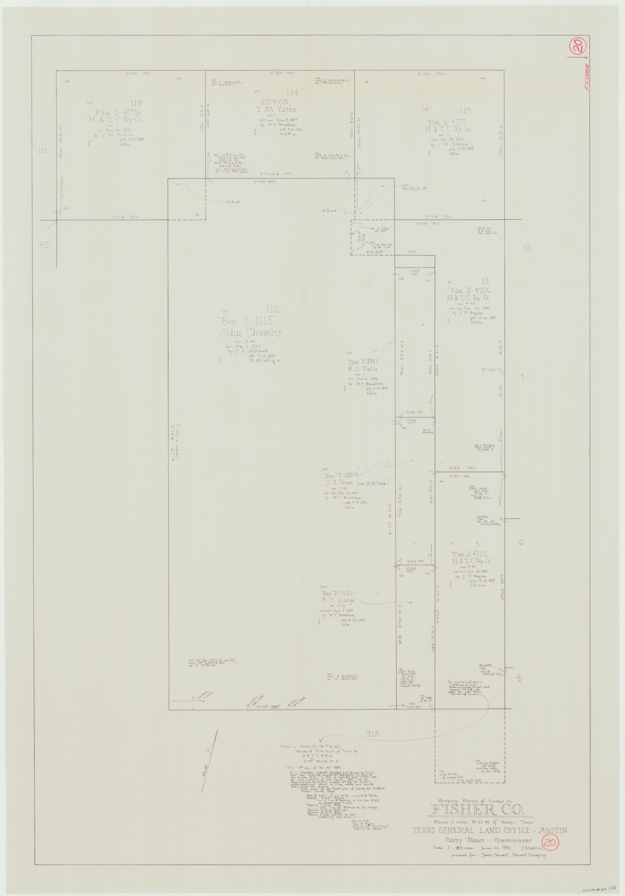
Fisher County Working Sketch 20
-
Map/Doc
69154
-
Collection
General Map Collection
-
Object Dates
1/21/1993 (Creation Date)
-
People and Organizations
Joan Kilpatrick (Draftsman)
-
Counties
Fisher
-
Subjects
Surveying Working Sketch
-
Height x Width
38.1 x 26.6 inches
96.8 x 67.6 cm
-
Scale
1" = 300 varas
Part of: General Map Collection
Pecos County Working Sketch 129

Print $20.00
- Digital $50.00
Pecos County Working Sketch 129
1976
Map/Doc 71603
Map of Kimble County

Print $20.00
- Digital $50.00
Map of Kimble County
1879
Size 18.7 x 28.9 inches
Map/Doc 3765
Val Verde County Working Sketch 90

Print $40.00
- Digital $50.00
Val Verde County Working Sketch 90
1974
Size 49.1 x 32.9 inches
Map/Doc 72225
Jasper County Working Sketch 14

Print $40.00
- Digital $50.00
Jasper County Working Sketch 14
1920
Size 37.9 x 55.1 inches
Map/Doc 66476
Haskell County Sketch File A

Print $4.00
- Digital $50.00
Haskell County Sketch File A
Size 7.8 x 11.9 inches
Map/Doc 26117
Flight Mission No. BRA-16M, Frame 139, Jefferson County

Print $20.00
- Digital $50.00
Flight Mission No. BRA-16M, Frame 139, Jefferson County
1953
Size 18.6 x 22.2 inches
Map/Doc 85745
Hunt County Sketch File 17

Print $8.00
- Digital $50.00
Hunt County Sketch File 17
1861
Size 10.6 x 8.2 inches
Map/Doc 27114
Milam County Rolled Sketch 3A

Print $40.00
- Digital $50.00
Milam County Rolled Sketch 3A
1967
Size 49.1 x 38.8 inches
Map/Doc 43048
Jefferson County Sketch File 25

Print $14.00
- Digital $50.00
Jefferson County Sketch File 25
1896
Size 7.6 x 6.7 inches
Map/Doc 28184
Gaines County Working Sketch 2

Print $20.00
- Digital $50.00
Gaines County Working Sketch 2
1939
Size 29.4 x 39.9 inches
Map/Doc 69302
Angelina County Working Sketch 20

Print $20.00
- Digital $50.00
Angelina County Working Sketch 20
1955
Size 18.8 x 15.0 inches
Map/Doc 67101
Dimmit County Sketch File 20a

Print $2.00
- Digital $50.00
Dimmit County Sketch File 20a
Size 9.3 x 4.3 inches
Map/Doc 21103
You may also like
Wilbarger County Working Sketch 3

Print $20.00
- Digital $50.00
Wilbarger County Working Sketch 3
1923
Size 22.0 x 23.9 inches
Map/Doc 72541
Goliad County Working Sketch 12

Print $20.00
- Digital $50.00
Goliad County Working Sketch 12
1942
Size 42.5 x 44.6 inches
Map/Doc 63202
Clay County Working Sketch 12

Print $20.00
- Digital $50.00
Clay County Working Sketch 12
1955
Size 30.6 x 39.4 inches
Map/Doc 68035
Map of Lampasas County

Print $20.00
- Digital $50.00
Map of Lampasas County
1856
Size 19.7 x 25.3 inches
Map/Doc 3792
Young County Rolled Sketch 9

Print $20.00
- Digital $50.00
Young County Rolled Sketch 9
1921
Size 24.0 x 22.6 inches
Map/Doc 8297

Chart showing the relative positions of the lights in the Eighth Light House District extending from Cedar Keys, Florida to Rio Grande, Texas

Print $20.00
- Digital $50.00
Chart showing the relative positions of the lights in the Eighth Light House District extending from Cedar Keys, Florida to Rio Grande, Texas
1876
Size 24.6 x 18.3 inches
Map/Doc 72679
Pecos County Working Sketch 104

Print $40.00
- Digital $50.00
Pecos County Working Sketch 104
1971
Size 63.1 x 26.9 inches
Map/Doc 71577
Houston County Sketch File 3

Print $6.00
- Digital $50.00
Houston County Sketch File 3
Size 13.1 x 8.2 inches
Map/Doc 26748
Stonewall County Sketch File 4

Print $20.00
- Digital $50.00
Stonewall County Sketch File 4
Size 18.2 x 25.7 inches
Map/Doc 12363
Borden County Working Sketch 16

Print $40.00
- Digital $50.00
Borden County Working Sketch 16
2007
Size 48.0 x 29.4 inches
Map/Doc 87206
Potter County Working Sketch 11

Print $20.00
- Digital $50.00
Potter County Working Sketch 11
1972
Size 27.4 x 26.4 inches
Map/Doc 71671