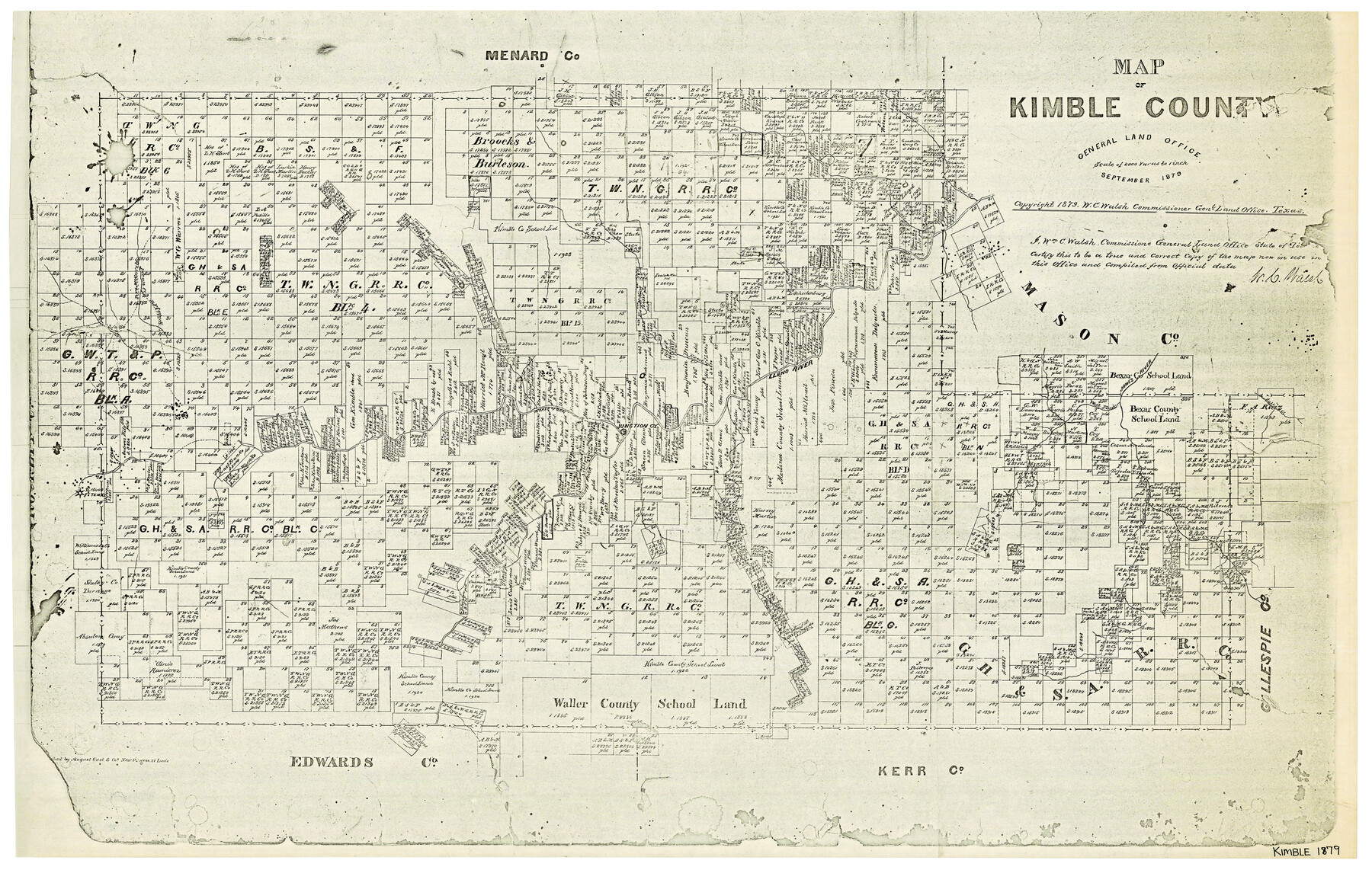
Map of Kimble County
-
Map/Doc
3765
-
Collection
General Map Collection
-
Object Dates
9/1879 (Creation Date)
-
People and Organizations
W.C. Walsh (GLO Commissioner)
August Gast & Co. (Lithographer)
-
Counties
Kimble
-
Subjects
County
-
Height x Width
18.7 x 28.9 inches
47.5 x 73.4 cm
-
Comments
Photostat of a lithograph copyrighted in 1879 and printed by August Gast and Company in St. Louis.
-
Features
Pecan Creek
Fort Terrett [sic]
Fall Creek
Shinoak Creek
East fork [of James River]
Junction City
South Fork [of Llano River]
Fitema
[Road] to Fort McKavett
[Road] to Fort Clark
Ionia Creek
North Fork [of Llano River]
Bluff Creek
Reed Creek
Llano River
Salt Creek
West Fork [of James River]
James River
Bear Creek
Part of: General Map Collection
Waller County Working Sketch 5

Print $20.00
- Digital $50.00
Waller County Working Sketch 5
1966
Size 23.1 x 27.1 inches
Map/Doc 72304
Upton County Rolled Sketch 31

Print $40.00
- Digital $50.00
Upton County Rolled Sketch 31
Size 27.2 x 53.4 inches
Map/Doc 10048
South Part Pecos County

Print $20.00
- Digital $50.00
South Part Pecos County
1976
Size 35.0 x 42.9 inches
Map/Doc 77393
Sabine County Sketch File 11

Print $4.00
Sabine County Sketch File 11
Size 6.2 x 8.3 inches
Map/Doc 35629
Flight Mission No. DAG-23K, Frame 18, Matagorda County

Print $20.00
- Digital $50.00
Flight Mission No. DAG-23K, Frame 18, Matagorda County
1953
Size 18.5 x 22.2 inches
Map/Doc 86480
Jack County Rolled Sketch 3A

Print $20.00
- Digital $50.00
Jack County Rolled Sketch 3A
1985
Size 34.9 x 32.2 inches
Map/Doc 6334
Calhoun County Working Sketch Graphic Index

Print $40.00
- Digital $50.00
Calhoun County Working Sketch Graphic Index
1948
Size 48.2 x 40.1 inches
Map/Doc 76484
Floyd County Boundary File 4

Print $4.00
- Digital $50.00
Floyd County Boundary File 4
Size 11.2 x 8.9 inches
Map/Doc 53494
Travis County Working Sketch 33

Print $20.00
- Digital $50.00
Travis County Working Sketch 33
1966
Size 35.0 x 37.2 inches
Map/Doc 69417
Stephens County Sketch File 16

Print $40.00
- Digital $50.00
Stephens County Sketch File 16
Size 38.2 x 72.1 inches
Map/Doc 10608
Flight Mission No. DQN-2K, Frame 74, Calhoun County

Print $20.00
- Digital $50.00
Flight Mission No. DQN-2K, Frame 74, Calhoun County
1953
Size 18.6 x 22.2 inches
Map/Doc 84266
Brewster County Working Sketch 1

Print $20.00
- Digital $50.00
Brewster County Working Sketch 1
1904
Size 27.4 x 25.8 inches
Map/Doc 67534
You may also like
Cass County Working Sketch 6

Print $20.00
- Digital $50.00
Cass County Working Sketch 6
1936
Size 19.7 x 23.0 inches
Map/Doc 67909
General Highway Map, Hunt County, Texas

Print $20.00
General Highway Map, Hunt County, Texas
1961
Size 24.7 x 18.2 inches
Map/Doc 79528
Pecos County Rolled Sketch 140

Print $20.00
- Digital $50.00
Pecos County Rolled Sketch 140
1954
Size 28.4 x 38.6 inches
Map/Doc 7275
Van Zandt County Rolled Sketch 11

Print $20.00
- Digital $50.00
Van Zandt County Rolled Sketch 11
2019
Size 23.6 x 36.0 inches
Map/Doc 95717
Llano County Working Sketch 15

Print $20.00
- Digital $50.00
Llano County Working Sketch 15
2007
Size 46.0 x 26.2 inches
Map/Doc 87372
Gaines County Rolled Sketch 16

Print $40.00
- Digital $50.00
Gaines County Rolled Sketch 16
1940
Size 51.2 x 36.0 inches
Map/Doc 9039
Webb County Rolled Sketch 60

Print $20.00
- Digital $50.00
Webb County Rolled Sketch 60
1947
Size 30.0 x 33.8 inches
Map/Doc 8211
Flight Mission No. DQO-12K, Frame 37, Galveston County

Print $20.00
- Digital $50.00
Flight Mission No. DQO-12K, Frame 37, Galveston County
1952
Size 18.7 x 22.4 inches
Map/Doc 85228
[Atchison, Topeka & Santa Fe from Paisano to south of Plata]
![64713, [Atchison, Topeka & Santa Fe from Paisano to south of Plata], General Map Collection](https://historictexasmaps.com/wmedia_w700/maps/64713-1.tif.jpg)
Print $40.00
- Digital $50.00
[Atchison, Topeka & Santa Fe from Paisano to south of Plata]
Size 32.2 x 116.3 inches
Map/Doc 64713
Texas in 1840, or the Emigrant's Guide to the New Republic; being the result of observation, enquiry and travel in that beautiful country

Texas in 1840, or the Emigrant's Guide to the New Republic; being the result of observation, enquiry and travel in that beautiful country
1840
Map/Doc 97198

Duval County Rolled Sketch 50

Print $20.00
- Digital $50.00
Duval County Rolled Sketch 50
1876
Size 14.2 x 11.8 inches
Map/Doc 5764