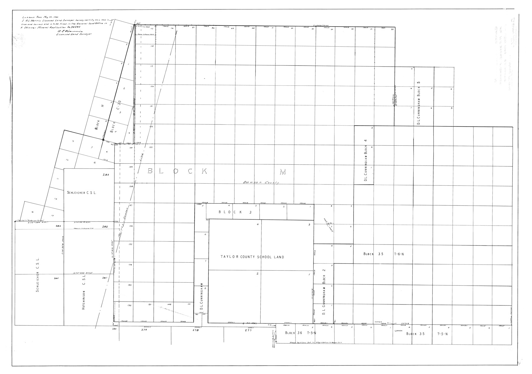
Gaines County Rolled Sketch 16
[Sketch on Gaines-Dawson county line re: MA 34595 F. Skinner]
-
Map/Doc
9039
-
Collection
General Map Collection
-
Object Dates
1940 (Creation Date)
1940/6/1 (File Date)
-
People and Organizations
A.L. Harris (Surveyor/Engineer)
-
Counties
Gaines Dawson
-
Subjects
Surveying Rolled Sketch
-
Height x Width
51.2 x 36.0 inches
130.0 x 91.4 cm
Part of: General Map Collection
Jones County Sketch File 7

Print $20.00
- Digital $50.00
Jones County Sketch File 7
Size 12.5 x 27.5 inches
Map/Doc 11897
Lipscomb County Working Sketch 6

Print $20.00
- Digital $50.00
Lipscomb County Working Sketch 6
1980
Size 35.7 x 20.8 inches
Map/Doc 70582
Shipping Safety Fairways and Anchorage Areas, Gulf of Mexico - Brazos Santiago Pass to Calcasieu Pass

Print $20.00
- Digital $50.00
Shipping Safety Fairways and Anchorage Areas, Gulf of Mexico - Brazos Santiago Pass to Calcasieu Pass
1968
Size 30.3 x 42.1 inches
Map/Doc 73632
Montgomery County Working Sketch 26

Print $20.00
- Digital $50.00
Montgomery County Working Sketch 26
1941
Size 40.8 x 30.7 inches
Map/Doc 71133
Mason County Working Sketch 1

Print $3.00
- Digital $50.00
Mason County Working Sketch 1
Size 10.7 x 16.2 inches
Map/Doc 70837
Coleman County Working Sketch 3

Print $20.00
- Digital $50.00
Coleman County Working Sketch 3
1918
Size 27.1 x 29.2 inches
Map/Doc 68069

Irion County Rolled Sketch 8

Print $20.00
- Digital $50.00
Irion County Rolled Sketch 8
Size 42.9 x 34.1 inches
Map/Doc 9251
Brewster County Rolled Sketch 114

Print $20.00
- Digital $50.00
Brewster County Rolled Sketch 114
1964
Size 11.7 x 18.3 inches
Map/Doc 5276
Chambers County Sketch File 24

Print $20.00
- Digital $50.00
Chambers County Sketch File 24
1909
Size 34.1 x 14.5 inches
Map/Doc 11065
Red River County Working Sketch 26

Print $20.00
- Digital $50.00
Red River County Working Sketch 26
1961
Size 30.9 x 31.6 inches
Map/Doc 72009
Edwards County Working Sketch 57

Print $20.00
- Digital $50.00
Edwards County Working Sketch 57
1952
Size 22.7 x 32.3 inches
Map/Doc 68933
You may also like
Roberts County Rolled Sketch 6

Print $20.00
- Digital $50.00
Roberts County Rolled Sketch 6
2018
Map/Doc 97395
The Republic County of Goliad. Proposed, Late Fall 1837-December 31, 1838

Print $20.00
The Republic County of Goliad. Proposed, Late Fall 1837-December 31, 1838
2020
Size 15.1 x 21.7 inches
Map/Doc 96148
Loving County Rolled Sketch 19

Print $20.00
- Digital $50.00
Loving County Rolled Sketch 19
2020
Size 24.4 x 35.3 inches
Map/Doc 96575
Flight Mission No. BRE-2P, Frame 51, Nueces County

Print $20.00
- Digital $50.00
Flight Mission No. BRE-2P, Frame 51, Nueces County
1956
Size 18.6 x 22.7 inches
Map/Doc 86753
Duval County Boundary File 3g

Print $4.00
- Digital $50.00
Duval County Boundary File 3g
Size 9.9 x 7.8 inches
Map/Doc 52747
Location of the Southern Kansas Railway of Texas, Roberts County, Texas

Print $40.00
- Digital $50.00
Location of the Southern Kansas Railway of Texas, Roberts County, Texas
1887
Size 20.0 x 75.1 inches
Map/Doc 64037
Flight Mission No. BRA-16M, Frame 120, Jefferson County

Print $20.00
- Digital $50.00
Flight Mission No. BRA-16M, Frame 120, Jefferson County
1953
Size 18.4 x 22.6 inches
Map/Doc 85730
North Part of Brewster Co.

Print $20.00
- Digital $50.00
North Part of Brewster Co.
1956
Size 42.4 x 40.7 inches
Map/Doc 95437
El Paso County Boundary File 4a

Print $44.00
- Digital $50.00
El Paso County Boundary File 4a
Size 14.1 x 8.6 inches
Map/Doc 53044
Galveston County NRC Article 33.136 Sketch 30

Print $20.00
- Digital $50.00
Galveston County NRC Article 33.136 Sketch 30
2005
Size 12.1 x 15.5 inches
Map/Doc 82997
Jeff Davis County Working Sketch 22

Print $20.00
- Digital $50.00
Jeff Davis County Working Sketch 22
1957
Size 18.9 x 20.9 inches
Map/Doc 66517
Jefferson County Rolled Sketch 23

Print $20.00
- Digital $50.00
Jefferson County Rolled Sketch 23
1938
Size 45.9 x 33.3 inches
Map/Doc 9289