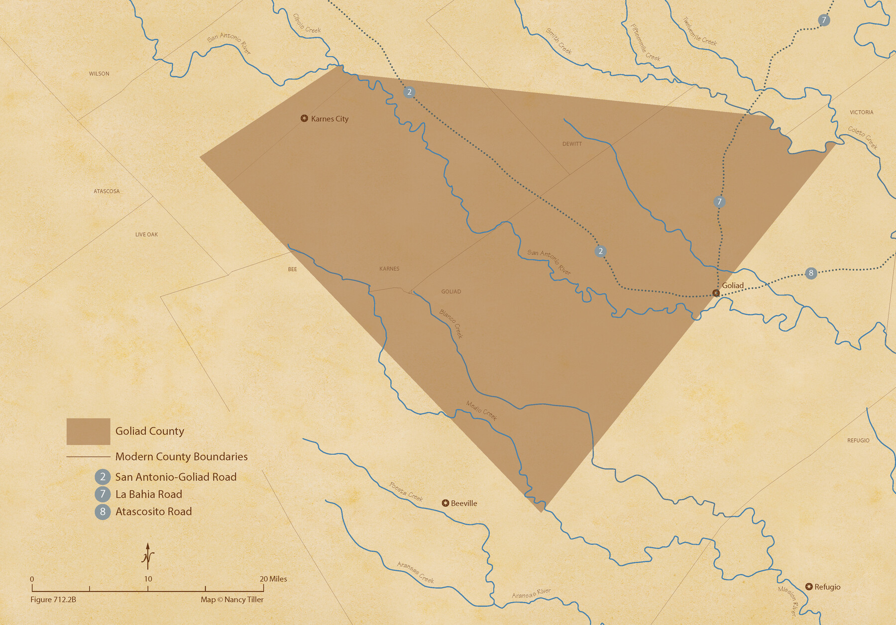
The Republic County of Goliad. Proposed, Late Fall 1837-December 31, 1838
Figure No. 712.2 from 'A Boundary Atlas of Texas, 1821-1845' by Jim Tiller
-
Map/Doc
96148
-
Collection
Nancy and Jim Tiller Digital Collection
-
Object Dates
2020/1/1 (Creation Date)
-
People and Organizations
Jim Tiller (Author)
Nancy Tiller (Cartographer)
Gang Gong (GIS Professional)
-
Counties
Goliad
-
Subjects
Atlas County Republic of Texas Texas Boundaries
-
Height x Width
15.1 x 21.7 inches
38.4 x 55.1 cm
-
Medium
digital image
-
Comments
To purchase a digital PDF copy of "A Boundary Atlas of Texas, 1821-1845" see 96437.
Part of: Nancy and Jim Tiller Digital Collection
The Republic County of San Augustine. December 29, 1845

Print $20.00
The Republic County of San Augustine. December 29, 1845
2020
Size 18.8 x 21.7 inches
Map/Doc 96272
The Republic County of Washington. January 15, 1842

Print $20.00
The Republic County of Washington. January 15, 1842
2020
Size 11.8 x 21.7 inches
Map/Doc 96306
The Republic County of Jackson. 1841

Print $20.00
The Republic County of Jackson. 1841
2020
Size 15.6 x 21.8 inches
Map/Doc 96187
The Chief Justice County of Nacogdoches. Lands in Conflict with Red River and Washington Counties

Print $20.00
The Chief Justice County of Nacogdoches. Lands in Conflict with Red River and Washington Counties
2020
Size 17.6 x 21.7 inches
Map/Doc 96064
The Judicial District/County of Pashcal. Created, January 28, 1841

Print $20.00
The Judicial District/County of Pashcal. Created, January 28, 1841
2020
Size 15.0 x 21.7 inches
Map/Doc 96343
The Republic County of Jackson. Spring 1842

Print $20.00
The Republic County of Jackson. Spring 1842
2020
Size 15.6 x 21.8 inches
Map/Doc 96190
Purnell and Lovell Empresario Colony. October 22, 1825

Print $20.00
Purnell and Lovell Empresario Colony. October 22, 1825
2020
Size 18.1 x 21.6 inches
Map/Doc 96005
The Pringle and Grieve Colony. November 1, 1843

Print $20.00
The Pringle and Grieve Colony. November 1, 1843
2020
Size 23.0 x 17.7 inches
Map/Doc 96371
The Republic County of Washington. January 30, 1841

Print $20.00
The Republic County of Washington. January 30, 1841
2020
Size 20.3 x 21.7 inches
Map/Doc 96305
The Mexican Municipality of Sabine. Created, December 15, 1835

Print $20.00
The Mexican Municipality of Sabine. Created, December 15, 1835
2020
Size 22.7 x 21.7 inches
Map/Doc 96031
The Land Offices. No. 11, Victoria, December 22, 1836

Print $20.00
The Land Offices. No. 11, Victoria, December 22, 1836
2020
Size 21.8 x 21.7 inches
Map/Doc 96424
Burnet Empresario Colony. December 22, 1826

Print $20.00
Burnet Empresario Colony. December 22, 1826
2020
Size 12.9 x 21.6 inches
Map/Doc 95985
You may also like
Duval County Rolled Sketch OS

Print $20.00
- Digital $50.00
Duval County Rolled Sketch OS
1903
Size 36.0 x 31.9 inches
Map/Doc 8803
Clay County, 1896

Print $40.00
- Digital $50.00
Clay County, 1896
1896
Size 34.4 x 55.4 inches
Map/Doc 89675
Gillespie County

Print $40.00
- Digital $50.00
Gillespie County
1887
Size 34.6 x 49.8 inches
Map/Doc 66836
Kinney County Working Sketch 55

Print $20.00
- Digital $50.00
Kinney County Working Sketch 55
1982
Size 25.1 x 24.7 inches
Map/Doc 70237
Garza County Sketch File F

Print $20.00
- Digital $50.00
Garza County Sketch File F
Size 9.8 x 18.9 inches
Map/Doc 11553
[St. Louis & Southwestern]
![64280, [St. Louis & Southwestern], General Map Collection](https://historictexasmaps.com/wmedia_w700/maps/64280.tif.jpg)
Print $20.00
- Digital $50.00
[St. Louis & Southwestern]
Size 20.3 x 27.9 inches
Map/Doc 64280
Sectional map of Texas traversed by the Missouri, Kansas & Texas Railway, showing the crops adapted to each section, with the elevation and annual rainfall

Print $20.00
- Digital $50.00
Sectional map of Texas traversed by the Missouri, Kansas & Texas Railway, showing the crops adapted to each section, with the elevation and annual rainfall
1904
Size 21.9 x 22.6 inches
Map/Doc 95813
Terrell County Working Sketch 61

Print $20.00
- Digital $50.00
Terrell County Working Sketch 61
1962
Size 20.3 x 34.3 inches
Map/Doc 69582
Reeves County Rolled Sketch 24

Print $20.00
- Digital $50.00
Reeves County Rolled Sketch 24
1982
Size 40.6 x 28.4 inches
Map/Doc 7492
Map of Burleson County

Print $20.00
- Digital $50.00
Map of Burleson County
1856
Size 22.0 x 31.5 inches
Map/Doc 3345
Padre Island National Seashore

Print $4.00
- Digital $50.00
Padre Island National Seashore
Size 16.2 x 22.1 inches
Map/Doc 60534
Flight Mission No. BRA-7M, Frame 23, Jefferson County

Print $20.00
- Digital $50.00
Flight Mission No. BRA-7M, Frame 23, Jefferson County
1953
Size 18.6 x 22.4 inches
Map/Doc 85474