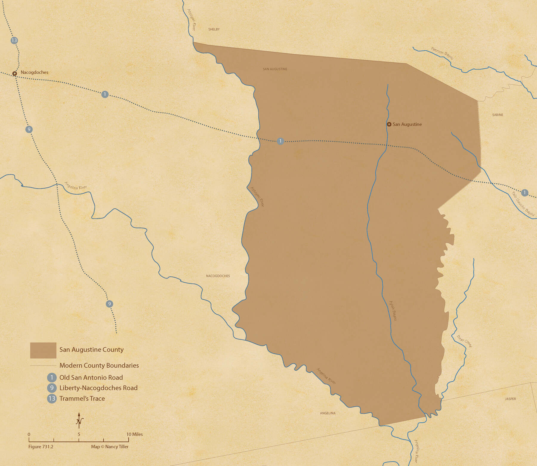
The Republic County of San Augustine. December 29, 1845
Figure No. 731.2 from 'A Boundary Atlas of Texas, 1821-1845' by Jim Tiller
- 
                          Map/Doc96272
- 
                            CollectionNancy and Jim Tiller Digital Collection
- 
                            Object Dates2020/1/1 (Creation Date)
- 
                            People and OrganizationsJim Tiller (Author)Nancy Tiller (Cartographer)Gang Gong (GIS Professional)
- 
                            CountiesSan Augustine
- 
                            SubjectsAtlas County Republic of Texas Texas Boundaries
- 
                            Height x Width18.8 x 21.7 inches47.8 x 55.1 cm
- 
                            Mediumdigital image
- 
                            CommentsTo purchase a digital PDF copy of "A Boundary Atlas of Texas, 1821-1845" see 96437.
Part of: Nancy and Jim Tiller Digital Collection
            de Leon Empresario Colony. April 15, 1824


                                            Print $20.00                    
                                    
                de Leon Empresario Colony. April 15, 1824
2020
Size 18.5 x 21.7 inches
                                Map/Doc 95988
            
            The Republic County of Colorado. 1840


                                            Print $20.00                    
                                    
                The Republic County of Colorado. 1840
2020
Size 18.4 x 21.7 inches
                                Map/Doc 96122
            
            The Republic County of Washington. February 4, 1840


                                            Print $20.00                    
                                    
                The Republic County of Washington. February 4, 1840
2020
Size 20.3 x 21.7 inches
                                Map/Doc 96304
            
            Austin Empresario Colony. April 27, 1825


                                            Print $20.00                    
                                    
                Austin Empresario Colony. April 27, 1825
2020
Size 18.1 x 21.6 inches
                                Map/Doc 95979
            
            The Republic County of Austin. February 5, 1840


                                            Print $20.00                    
                                    
                The Republic County of Austin. February 5, 1840
2020
Size 14.7 x 21.7 inches
                                Map/Doc 96084
            
            The Republic County of Travis. December 29, 1845


                                            Print $20.00                    
                                    
                The Republic County of Travis. December 29, 1845
2020
Size 20.8 x 21.6 inches
                                Map/Doc 96293
            
            The Republic County of Jackson. Spring 1842


                                            Print $20.00                    
                                    
                The Republic County of Jackson. Spring 1842
2020
Size 15.6 x 21.8 inches
                                Map/Doc 96190
            
            Republic Counties. January 1, 1842


                                            Print $20.00                    
                                    
                Republic Counties. January 1, 1842
2020
Size 24.5 x 21.7 inches
                                Map/Doc 96315
            
            The Republic County of Travis. Spring 1842


                                            Print $20.00                    
                                    
                The Republic County of Travis. Spring 1842
2020
Size 20.8 x 21.6 inches
                                Map/Doc 96292
            
            The Mexican Municipalities. On the Eve of Texas Independence, 1836


                                            Print $20.00                    
                                    
                The Mexican Municipalities. On the Eve of Texas Independence, 1836
2020
Size 17.2 x 21.6 inches
                                Map/Doc 96013
            
            The Republic County of Houston. February 2, 1842


                                            Print $20.00                    
                                    
                The Republic County of Houston. February 2, 1842
2020
Size 19.7 x 21.8 inches
                                Map/Doc 96181
            
            The Republic County of Fayette. May 24, 1838


                                            Print $20.00                    
                                    
                The Republic County of Fayette. May 24, 1838
2020
Size 14.7 x 21.7 inches
                                Map/Doc 96133
            You may also like
            [Surveys in Austin's Colony along the San Bernardo River from the mouth of Peach Creek]
            
                                    ![209, [Surveys in Austin's Colony along the San Bernardo River from the mouth of Peach Creek], General Map Collection](https://historictexasmaps.com/wmedia_w700/maps/209.tif.jpg) 


    ![209, [Surveys in Austin's Colony along the San Bernardo River from the mouth of Peach Creek], General Map Collection](https://historictexasmaps.com/wmedia_w700/maps/209.tif.jpg) 
                                
            
                                            Print $20.00                    
                                             -                         Digital $50.00                                    
                [Surveys in Austin's Colony along the San Bernardo River from the mouth of Peach Creek]
1821
Size 23.4 x 10.6 inches
                                Map/Doc 209
            
            Angelina County Working Sketch 46


                                            Print $20.00                    
                                             -                         Digital $50.00                                    
                Angelina County Working Sketch 46
1976
Size 31.2 x 31.3 inches
                                Map/Doc 67129
            
            Travis County Working Sketch 63


                                            Print $20.00                    
                                             -                         Digital $50.00                                    
                Travis County Working Sketch 63
1998
Size 24.0 x 29.5 inches
                                Map/Doc 69447
            
            Starr County Rolled Sketch 2


                                            Print $40.00                    
                                             -                         Digital $50.00                                    
                Starr County Rolled Sketch 2
1853
Size 31.7 x 48.5 inches
                                Map/Doc 9938
            
            Dietzgen Globe Wooden 24" T Square


            Dietzgen Globe Wooden 24" T Square
Size 26.0 x 9.3 inches
                                Map/Doc 97324
            
            Reeves County Rolled Sketch 18


                                            Print $20.00                    
                                             -                         Digital $50.00                                    
                Reeves County Rolled Sketch 18
1963
Size 23.4 x 27.4 inches
                                Map/Doc 7487
            
            [Garza, Blanco, Uvalde and Crosby County School Land]
            
                                    ![90252, [Garza, Blanco, Uvalde and Crosby County School Land], Twichell Survey Records](https://historictexasmaps.com/wmedia_w700/maps/90252-1.tif.jpg) 


    ![90252, [Garza, Blanco, Uvalde and Crosby County School Land], Twichell Survey Records](https://historictexasmaps.com/wmedia_w700/maps/90252-1.tif.jpg) 
                                
            
                                            Print $20.00                    
                                             -                         Digital $50.00                                    
                [Garza, Blanco, Uvalde and Crosby County School Land]
1913
Size 12.4 x 12.2 inches
                                Map/Doc 90252
            
            Martha's Vineyard to Block Island Including Western Approach to Cape Cod Canal


                                            Print $20.00                    
                                             -                         Digital $50.00                                    
                Martha's Vineyard to Block Island Including Western Approach to Cape Cod Canal
1963
Size 37.5 x 45.7 inches
                                Map/Doc 73554
            
            Dimmit County Rolled Sketch 14


                                            Print $40.00                    
                                             -                         Digital $50.00                                    
                Dimmit County Rolled Sketch 14
1945
Size 56.6 x 36.0 inches
                                Map/Doc 8797
            
            The New Naval and Military Map of the United States


                                            Print $40.00                    
                                    
                The New Naval and Military Map of the United States
Size 68.5 x 68.5 inches
                                Map/Doc 95309
            
            Leon County Rolled Sketch 6


                                            Print $20.00                    
                                             -                         Digital $50.00                                    
                Leon County Rolled Sketch 6
1951
Size 31.6 x 37.6 inches
                                Map/Doc 6597
            
            Cottle County Working Sketch 23


                                            Print $20.00                    
                                             -                         Digital $50.00                                    
                Cottle County Working Sketch 23
1992
Size 26.6 x 24.2 inches
                                Map/Doc 68333
            