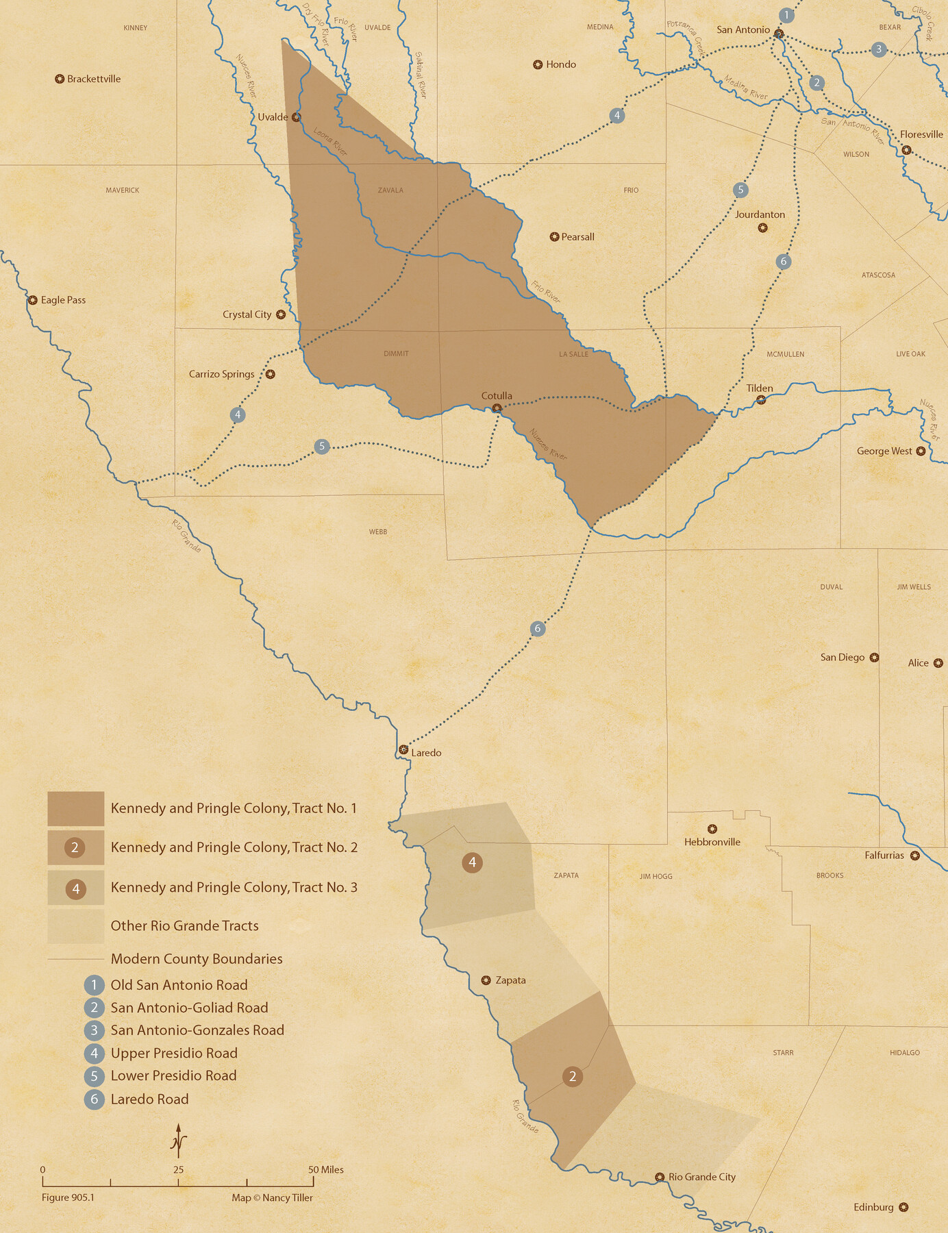
The Kennedy and Pringle Colony. February 15, 1842
Figure No. 905.1 from 'A Boundary Atlas of Texas, 1821-1845' by Jim Tiller
-
Map/Doc
96367
-
Collection
Nancy and Jim Tiller Digital Collection
-
Object Dates
2020/1/1 (Creation Date)
-
People and Organizations
Jim Tiller (Author)
Nancy Tiller (Cartographer)
Gang Gong (GIS Professional)
-
Subjects
Atlas Colony Republic of Texas Texas Boundaries
-
Height x Width
23.0 x 17.7 inches
58.4 x 45.0 cm
-
Medium
digital image
-
Comments
To purchase a digital PDF copy of "A Boundary Atlas of Texas, 1821-1845" see 96437.
Part of: Nancy and Jim Tiller Digital Collection
de Leon Empresario Colony. Absorbed by DeWitt Colony. April 15, 1825

Print $20.00
de Leon Empresario Colony. Absorbed by DeWitt Colony. April 15, 1825
2020
Size 18.5 x 21.7 inches
Map/Doc 95989
The Republic County of Harrison. Created, January 28, 1839

Print $20.00
The Republic County of Harrison. Created, January 28, 1839
2020
Size 18.6 x 21.7 inches
Map/Doc 96169
The Republic County of Fort Bend. February 4, 1841

Print $20.00
The Republic County of Fort Bend. February 4, 1841
2020
Size 14.7 x 21.6 inches
Map/Doc 96141
The Mexican Municipality of Gonzales. April 1834

Print $20.00
The Mexican Municipality of Gonzales. April 1834
2020
Size 20.4 x 21.7 inches
Map/Doc 96021
The Republic County of San Patricio. 1840

Print $20.00
The Republic County of San Patricio. 1840
2020
Size 22.2 x 21.7 inches
Map/Doc 96276
The Republic County of Victoria. Boundaries Refined, January 25, 1841

Print $20.00
The Republic County of Victoria. Boundaries Refined, January 25, 1841
2020
Size 19.3 x 21.8 inches
Map/Doc 96297
The Republic County of Colorado. January 29, 1842

Print $20.00
The Republic County of Colorado. January 29, 1842
2020
Size 18.4 x 21.7 inches
Map/Doc 96125
The Chief Justice County of Colorado. Lands in Conflict with Brazoria, Mina Counties

Print $20.00
The Chief Justice County of Colorado. Lands in Conflict with Brazoria, Mina Counties
2020
Size 14.8 x 21.7 inches
Map/Doc 96045
The Republic County of Liberty. Spring 1842

Print $20.00
The Republic County of Liberty. Spring 1842
2020
Size 19.9 x 21.7 inches
Map/Doc 96212
The Judicial District/Counties, Late Spring 1842

Print $20.00
The Judicial District/Counties, Late Spring 1842
2020
Size 24.5 x 21.7 inches
Map/Doc 96356
The Republic County of Houston. January 30, 1841

Print $20.00
The Republic County of Houston. January 30, 1841
2020
Size 19.7 x 21.8 inches
Map/Doc 96179
The Republic County of Washington. Spring 1842

Print $20.00
The Republic County of Washington. Spring 1842
2020
Size 11.8 x 21.7 inches
Map/Doc 96308
You may also like
Wilbarger County Sketch File 24

Print $20.00
- Digital $50.00
Wilbarger County Sketch File 24
1894
Size 23.3 x 14.9 inches
Map/Doc 12691
Hamilton County Sketch File 24

Print $20.00
- Digital $50.00
Hamilton County Sketch File 24
1953
Size 23.2 x 22.8 inches
Map/Doc 11619

Kleberg County Rolled Sketch 5

Print $20.00
- Digital $50.00
Kleberg County Rolled Sketch 5
Size 27.8 x 21.8 inches
Map/Doc 6548
Val Verde County Sketch File DD and DD1

Print $64.00
- Digital $50.00
Val Verde County Sketch File DD and DD1
1889
Size 8.9 x 7.9 inches
Map/Doc 39067
Young County Working Sketch 8

Print $20.00
- Digital $50.00
Young County Working Sketch 8
1920
Size 17.3 x 12.6 inches
Map/Doc 62031
La Salle County Sketch File 9

Print $4.00
- Digital $50.00
La Salle County Sketch File 9
Size 6.3 x 8.3 inches
Map/Doc 29458
La Salle County Sketch File 22

Print $4.00
- Digital $50.00
La Salle County Sketch File 22
1875
Size 12.8 x 8.2 inches
Map/Doc 29528
Fort Bend County State Real Property Sketch 10

Print $40.00
- Digital $50.00
Fort Bend County State Real Property Sketch 10
1985
Size 43.4 x 34.7 inches
Map/Doc 61684
Current Miscellaneous File 11

Print $50.00
- Digital $50.00
Current Miscellaneous File 11
1930
Size 11.2 x 8.7 inches
Map/Doc 73778
Flight Mission No. CGI-3N, Frame 179, Cameron County

Print $20.00
- Digital $50.00
Flight Mission No. CGI-3N, Frame 179, Cameron County
1954
Size 18.6 x 22.2 inches
Map/Doc 84643
Loving County

Print $20.00
- Digital $50.00
Loving County
1889
Size 24.6 x 19.6 inches
Map/Doc 91385