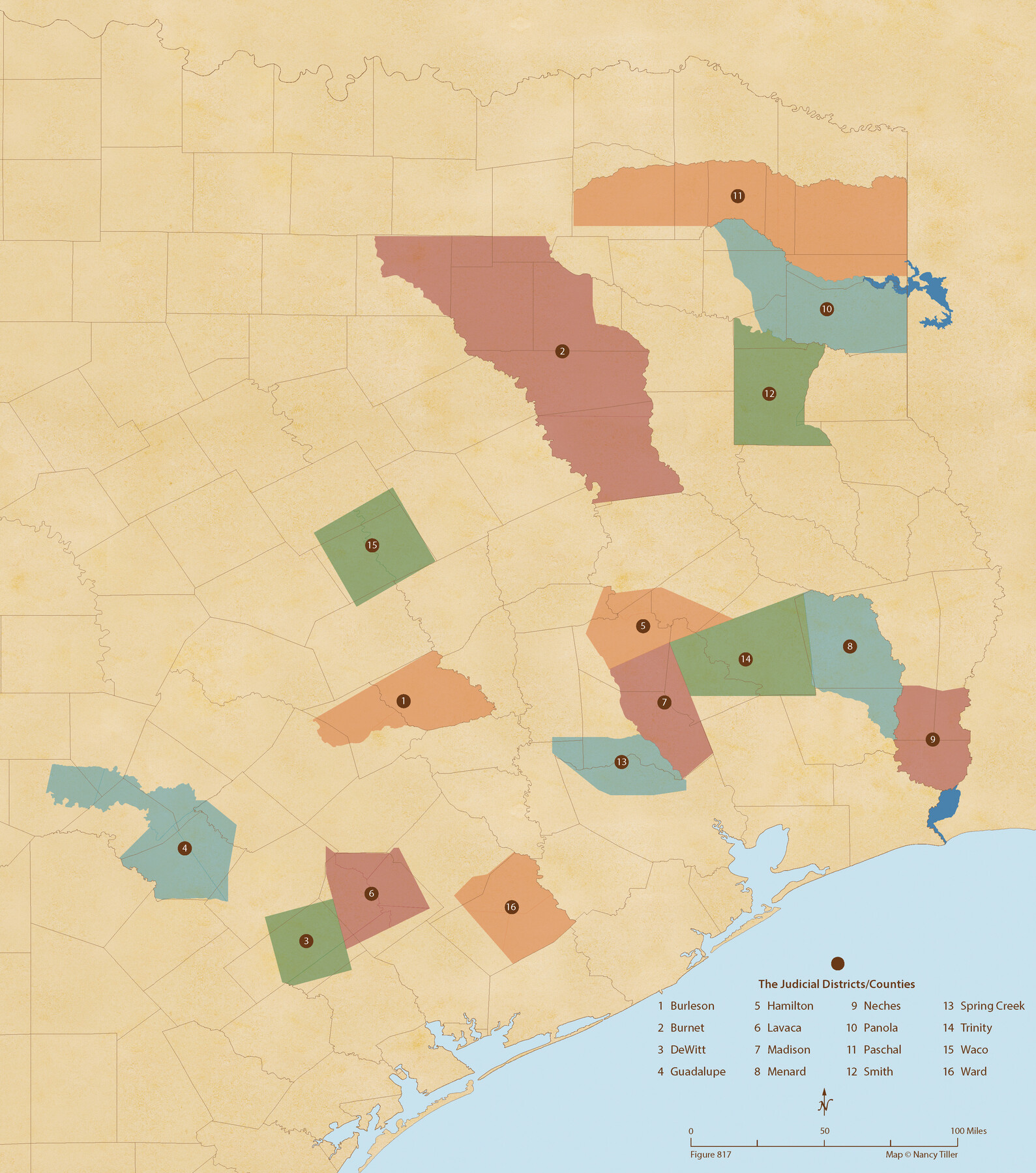
The Judicial District/Counties, Late Spring 1842
Figure No. 817 from 'A Boundary Atlas of Texas, 1821-1845' by Jim Tiller
-
Map/Doc
96356
-
Collection
Nancy and Jim Tiller Digital Collection
-
Object Dates
2020/1/1 (Creation Date)
-
People and Organizations
Jim Tiller (Author)
Nancy Tiller (Cartographer)
Gang Gong (GIS Professional)
-
Subjects
Atlas Republic of Texas Texas Boundaries
-
Height x Width
24.5 x 21.7 inches
62.2 x 55.1 cm
-
Medium
digital image
-
Comments
To purchase a digital PDF copy of "A Boundary Atlas of Texas, 1821-1845" see 96437.
Part of: Nancy and Jim Tiller Digital Collection
The Republic County of Gonzales. Boundaries Defined, December 14, 1837

Print $20.00
The Republic County of Gonzales. Boundaries Defined, December 14, 1837
2020
Size 14.7 x 21.7 inches
Map/Doc 96153
The Chief Justice County of Jasper. April 21, 1837

Print $20.00
The Chief Justice County of Jasper. April 21, 1837
2020
Size 18.3 x 21.7 inches
Map/Doc 96052
Austin Empresario Colony. January 17, 1821/February 18, 1823

Print $20.00
Austin Empresario Colony. January 17, 1821/February 18, 1823
2020
Size 18.8 x 21.6 inches
Map/Doc 95978
The Republic County of Robertson. Spring 1842

Print $20.00
The Republic County of Robertson. Spring 1842
2020
Size 16.9 x 21.7 inches
Map/Doc 96263
The Republic County of San Patricio. Proposed, Late Fall 1837

Print $20.00
The Republic County of San Patricio. Proposed, Late Fall 1837
2020
Size 17.8 x 21.7 inches
Map/Doc 96273
The Republic County of Houston. December 6, 1841

Print $20.00
The Republic County of Houston. December 6, 1841
2020
Size 19.7 x 21.8 inches
Map/Doc 96180
The Republic County of Houston. February 2, 1842

Print $20.00
The Republic County of Houston. February 2, 1842
2020
Size 19.7 x 21.8 inches
Map/Doc 96181
The d’Orvane Colony. June 3, 1842

Print $20.00
The d’Orvane Colony. June 3, 1842
2020
Size 13.1 x 21.7 inches
Map/Doc 96369
From Citizens of Montgomery and Washington Counties to Redefine the Boundary Between Their Two Counties, Undated

Print $20.00
From Citizens of Montgomery and Washington Counties to Redefine the Boundary Between Their Two Counties, Undated
2020
Size 15.0 x 21.7 inches
Map/Doc 96402
The Republic County of Nacogdoches. Proposed, Late Fall 1837

Print $20.00
The Republic County of Nacogdoches. Proposed, Late Fall 1837
2020
Size 17.5 x 21.7 inches
Map/Doc 96242
The Republic County of Bastrop. May 24, 1838

Print $20.00
The Republic County of Bastrop. May 24, 1838
2020
Size 17.8 x 21.7 inches
Map/Doc 96090
The Chief Justice County of Liberty. April 25, 1837

Print $20.00
The Chief Justice County of Liberty. April 25, 1837
2020
Size 20.5 x 21.7 inches
Map/Doc 96055
You may also like
Cameron County Rolled Sketch 20B

Print $20.00
- Digital $50.00
Cameron County Rolled Sketch 20B
Size 24.3 x 12.7 inches
Map/Doc 5473
Williamson County Sketch File 23

Print $4.00
- Digital $50.00
Williamson County Sketch File 23
1877
Size 12.8 x 8.1 inches
Map/Doc 40353
A New and Correct Map of North America, with the West India Islands

Print $20.00
- Digital $50.00
A New and Correct Map of North America, with the West India Islands
1784
Size 44.0 x 52.2 inches
Map/Doc 93828
Sterling County Working Sketch 1

Print $20.00
- Digital $50.00
Sterling County Working Sketch 1
1926
Size 30.3 x 29.6 inches
Map/Doc 63983
Foard County Sketch File 37

Print $4.00
- Digital $50.00
Foard County Sketch File 37
1891
Size 11.2 x 9.1 inches
Map/Doc 22869
San Augustine Co.

Print $20.00
- Digital $50.00
San Augustine Co.
1949
Size 45.7 x 28.6 inches
Map/Doc 77414
L Sketch from Ward and Crane Co's

Print $20.00
- Digital $50.00
L Sketch from Ward and Crane Co's
Size 39.6 x 23.2 inches
Map/Doc 90462
Working Sketch from Lynn & Garza Counties

Print $20.00
- Digital $50.00
Working Sketch from Lynn & Garza Counties
1902
Size 35.8 x 30.6 inches
Map/Doc 93223
General Highway Map, Medina County, Texas

Print $20.00
General Highway Map, Medina County, Texas
1940
Size 18.3 x 24.5 inches
Map/Doc 79194
Lamar County Sketch File 13

Print $2.00
- Digital $50.00
Lamar County Sketch File 13
1943
Size 10.9 x 8.0 inches
Map/Doc 29307
Glasscock County Boundary File 1

Print $18.00
- Digital $50.00
Glasscock County Boundary File 1
Size 14.4 x 9.0 inches
Map/Doc 53781
Cooke County Working Sketch 18

Print $20.00
- Digital $50.00
Cooke County Working Sketch 18
1952
Size 23.5 x 19.6 inches
Map/Doc 68255