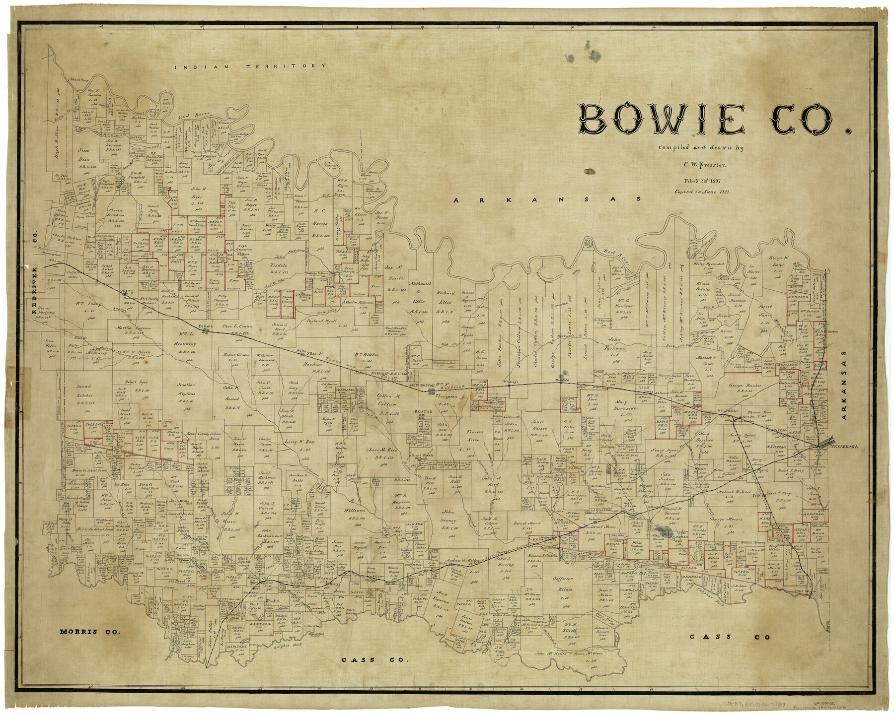
Bowie Co.
- 
                          Map/Doc4889
- 
                            CollectionGeneral Map Collection
- 
                            Object Dates2/2/1897 (Creation Date)
- 
                            People and OrganizationsChas. W. Pressler (Draftsman)
- 
                            CountiesBowie
- 
                            SubjectsCounty
- 
                            Height x Width36.0 x 45.0 inches91.4 x 114.3 cm
- 
                            CommentsCopied in June 1899.
Part of: General Map Collection
            Walker County


                                            Print $20.00                    
                                             -                         Digital $50.00                                    
                Walker County
1944
Size 46.1 x 38.2 inches
                                Map/Doc 95664
            
            Brooks County Sketch File 3


                                            Print $40.00                    
                                             -                         Digital $50.00                                    
                Brooks County Sketch File 3
Size 21.5 x 19.0 inches
                                Map/Doc 11016
            
            Texas Coast, No. 17


                                            Print $20.00                    
                                             -                         Digital $50.00                                    
                Texas Coast, No. 17
Size 18.3 x 26.1 inches
                                Map/Doc 72713
            
            Navigation Maps of Gulf Intracoastal Waterway, Port Arthur to Brownsville, Texas


                                            Print $4.00                    
                                             -                         Digital $50.00                                    
                Navigation Maps of Gulf Intracoastal Waterway, Port Arthur to Brownsville, Texas
1951
Size 16.7 x 21.2 inches
                                Map/Doc 65449
            
            Cameron County Sketch File 1


                                            Print $7.00                    
                                             -                         Digital $50.00                                    
                Cameron County Sketch File 1
1849
Size 10.9 x 8.6 inches
                                Map/Doc 36024
            
            [Sketch for Mineral Application 17237 / Mineral File 11855 - Neches River, Joe A. Sanders]
            
                                    ![65687, [Sketch for Mineral Application 17237 / Mineral File 11855 - Neches River, Joe A. Sanders], General Map Collection](https://historictexasmaps.com/wmedia_w700/maps/65687.tif.jpg) 


    ![65687, [Sketch for Mineral Application 17237 / Mineral File 11855 - Neches River, Joe A. Sanders], General Map Collection](https://historictexasmaps.com/wmedia_w700/maps/65687.tif.jpg) 
                                
            
                                            Print $40.00                    
                                             -                         Digital $50.00                                    
                [Sketch for Mineral Application 17237 / Mineral File 11855 - Neches River, Joe A. Sanders]
1927
Size 78.5 x 31.2 inches
                                Map/Doc 65687
            
            Map of Bee County


                                            Print $20.00                    
                                             -                         Digital $50.00                                    
                Map of Bee County
1879
Size 25.1 x 22.7 inches
                                Map/Doc 3289
            
            McLennan County Boundary File 4a


                                            Print $8.00                    
                                             -                         Digital $50.00                                    
                McLennan County Boundary File 4a
Size 14.1 x 8.6 inches
                                Map/Doc 56979
            
            [St. L. S-W. Ry. of Texas Map of Lufkin Branch in Angelina County, Texas]
            
                                    ![64560, [St. L. S-W. Ry. of Texas Map of Lufkin Branch in Angelina County, Texas], General Map Collection](https://historictexasmaps.com/wmedia_w700/maps/64560-1.tif.jpg) 


    ![64560, [St. L. S-W. Ry. of Texas Map of Lufkin Branch in Angelina County, Texas], General Map Collection](https://historictexasmaps.com/wmedia_w700/maps/64560-1.tif.jpg) 
                                
            
                                            Print $40.00                    
                                             -                         Digital $50.00                                    
                [St. L. S-W. Ry. of Texas Map of Lufkin Branch in Angelina County, Texas]
1913
Size 25.7 x 121.3 inches
                                Map/Doc 64560
            
            Hardin County Working Sketch 41


                                            Print $20.00                    
                                             -                         Digital $50.00                                    
                Hardin County Working Sketch 41
Size 35.1 x 40.0 inches
                                Map/Doc 63440
            
            Hutchinson County Rolled Sketch 36A


                                            Print $20.00                    
                                             -                         Digital $50.00                                    
                Hutchinson County Rolled Sketch 36A
1888
Size 21.3 x 25.0 inches
                                Map/Doc 6294
            
            Newton County Rolled Sketch 21


                                            Print $40.00                    
                                             -                         Digital $50.00                                    
                Newton County Rolled Sketch 21
1957
Size 29.9 x 52.5 inches
                                Map/Doc 9582
            You may also like
            DeWitt County Rolled Sketch 3


                                            Print $20.00                    
                                             -                         Digital $50.00                                    
                DeWitt County Rolled Sketch 3
1950
Size 19.9 x 37.8 inches
                                Map/Doc 5703
            
            Hartley County


                                            Print $20.00                    
                                             -                         Digital $50.00                                    
                Hartley County
1882
Size 30.2 x 19.3 inches
                                Map/Doc 90708
            
            Flight Mission No. CRK-8P, Frame 97, Refugio County


                                            Print $20.00                    
                                             -                         Digital $50.00                                    
                Flight Mission No. CRK-8P, Frame 97, Refugio County
1956
Size 18.5 x 22.1 inches
                                Map/Doc 86958
            
            Township 9 South Range 13 West, South Western District, Louisiana


                                            Print $20.00                    
                                             -                         Digital $50.00                                    
                Township 9 South Range 13 West, South Western District, Louisiana
1858
Size 19.8 x 24.8 inches
                                Map/Doc 65852
            
            Flight Mission No. CRC-3R, Frame 20, Chambers County


                                            Print $20.00                    
                                             -                         Digital $50.00                                    
                Flight Mission No. CRC-3R, Frame 20, Chambers County
1956
Size 18.6 x 22.2 inches
                                Map/Doc 84794
            
            Donley County Working Sketch 6


                                            Print $20.00                    
                                             -                         Digital $50.00                                    
                Donley County Working Sketch 6
1965
Size 34.3 x 42.2 inches
                                Map/Doc 68739
            
            Threading the Islands: Which track fits?


            Threading the Islands: Which track fits?
1986
Size 20.5 x 14.7 inches
                                Map/Doc 96838
            
            Harrison County Working Sketch 32


                                            Print $20.00                    
                                             -                         Digital $50.00                                    
                Harrison County Working Sketch 32
2015
Size 29.9 x 24.0 inches
                                Map/Doc 93724
            
            Tom Green County Rolled Sketch 14


                                            Print $20.00                    
                                             -                         Digital $50.00                                    
                Tom Green County Rolled Sketch 14
1953
Size 28.3 x 30.9 inches
                                Map/Doc 7999
            
            Nueces County NRC Article 33.136 Sketch 17


                                            Print $26.00                    
                                             -                         Digital $50.00                                    
                Nueces County NRC Article 33.136 Sketch 17
2013
Size 18.0 x 24.0 inches
                                Map/Doc 94487
            
            Sabine County Working Sketch 5


                                            Print $20.00                    
                                             -                         Digital $50.00                                    
                Sabine County Working Sketch 5
1918
Size 17.3 x 17.3 inches
                                Map/Doc 63676
             
                        