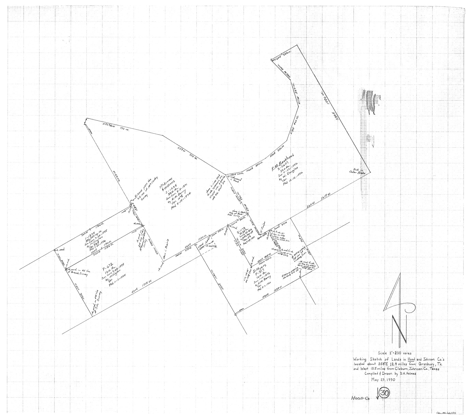
Hood County Working Sketch 30
-
Map/Doc
66224
-
Collection
General Map Collection
-
Object Dates
5/29/1990 (Creation Date)
-
People and Organizations
David Holmes (Draftsman)
-
Counties
Hood Johnson
-
Subjects
Surveying Working Sketch
-
Height x Width
26.6 x 29.9 inches
67.6 x 76.0 cm
-
Scale
1" = 200 varas
Part of: General Map Collection
Zapata County Sketch File 5

Print $20.00
- Digital $50.00
Zapata County Sketch File 5
1886
Size 15.4 x 16.9 inches
Map/Doc 12719
Map of Anderson County

Print $20.00
- Digital $50.00
Map of Anderson County
1895
Size 40.9 x 45.4 inches
Map/Doc 4784
St. Marks to Galveston - Sheet II

Print $20.00
- Digital $50.00
St. Marks to Galveston - Sheet II
1846
Size 26.5 x 40.5 inches
Map/Doc 97397
Harrison County Working Sketch 13

Print $20.00
- Digital $50.00
Harrison County Working Sketch 13
1961
Size 32.4 x 37.0 inches
Map/Doc 66033
Menard County Working Sketch 6

Print $20.00
- Digital $50.00
Menard County Working Sketch 6
1924
Size 24.4 x 15.3 inches
Map/Doc 70953
Map of Crockett County

Print $40.00
- Digital $50.00
Map of Crockett County
1878
Size 62.6 x 49.7 inches
Map/Doc 93373
Red River County Working Sketch 3

Print $20.00
- Digital $50.00
Red River County Working Sketch 3
1919
Size 14.2 x 12.8 inches
Map/Doc 71986
Throckmorton County Working Sketch 8

Print $20.00
- Digital $50.00
Throckmorton County Working Sketch 8
1958
Size 21.6 x 30.4 inches
Map/Doc 62117
Map of the City of Washington showing location of fatal cases of Diphtheria and Scarlet Fever; also number of cases thereof reported to the Health Department during the year ending June 30, 1896

Print $20.00
- Digital $50.00
Map of the City of Washington showing location of fatal cases of Diphtheria and Scarlet Fever; also number of cases thereof reported to the Health Department during the year ending June 30, 1896
1896
Size 30.0 x 29.4 inches
Map/Doc 97103
Ward County Sketch File 10

Print $6.00
- Digital $50.00
Ward County Sketch File 10
1936
Size 11.2 x 8.9 inches
Map/Doc 39635
Maverick County Sketch File 14

Print $4.00
- Digital $50.00
Maverick County Sketch File 14
1883
Size 11.1 x 8.5 inches
Map/Doc 31111
Flight Mission No. DAG-18K, Frame 73, Matagorda County

Print $20.00
- Digital $50.00
Flight Mission No. DAG-18K, Frame 73, Matagorda County
1952
Size 18.5 x 22.2 inches
Map/Doc 86366
You may also like
General Highway Map, Culberson County, Texas

Print $20.00
General Highway Map, Culberson County, Texas
1961
Size 24.9 x 18.2 inches
Map/Doc 79427
San Jacinto County Sketch File 12

Print $4.00
San Jacinto County Sketch File 12
1873
Size 9.7 x 8.2 inches
Map/Doc 35720
Hemphill County Working Sketch 14

Print $20.00
- Digital $50.00
Hemphill County Working Sketch 14
1969
Size 34.0 x 44.8 inches
Map/Doc 66109
Zavala County

Print $20.00
- Digital $50.00
Zavala County
1977
Size 36.6 x 41.6 inches
Map/Doc 77468
Terrell County Sketch File 25

Print $4.00
- Digital $50.00
Terrell County Sketch File 25
1935
Size 13.5 x 8.1 inches
Map/Doc 37959
Runnels County Rolled Sketch 38

Print $20.00
- Digital $50.00
Runnels County Rolled Sketch 38
1950
Size 33.9 x 46.6 inches
Map/Doc 7524
Ward County Working Sketch 31

Print $40.00
- Digital $50.00
Ward County Working Sketch 31
1967
Size 32.0 x 75.6 inches
Map/Doc 72337
Fort Bend County Sketch File 9

Print $20.00
- Digital $50.00
Fort Bend County Sketch File 9
Size 18.8 x 16.5 inches
Map/Doc 11500
Jefferson County Sketch File 10

Print $32.00
- Digital $50.00
Jefferson County Sketch File 10
Size 8.0 x 6.8 inches
Map/Doc 28125
Coast Chart No. 210 Aransas Pass and Corpus Christi Bay with the coast to latitude 27° 12' Texas

Print $20.00
- Digital $50.00
Coast Chart No. 210 Aransas Pass and Corpus Christi Bay with the coast to latitude 27° 12' Texas
1887
Size 27.5 x 18.2 inches
Map/Doc 72802
Houston County

Print $40.00
- Digital $50.00
Houston County
1944
Size 50.3 x 50.3 inches
Map/Doc 73184
Map of Wyoming Showing Test Wells for Oil and Gas, Anticlinal Axes, Oil and Gas Fields, Pipeline, Unit Areas and Land District Boundaries

Print $40.00
- Digital $50.00
Map of Wyoming Showing Test Wells for Oil and Gas, Anticlinal Axes, Oil and Gas Fields, Pipeline, Unit Areas and Land District Boundaries
1949
Size 55.2 x 42.6 inches
Map/Doc 89886