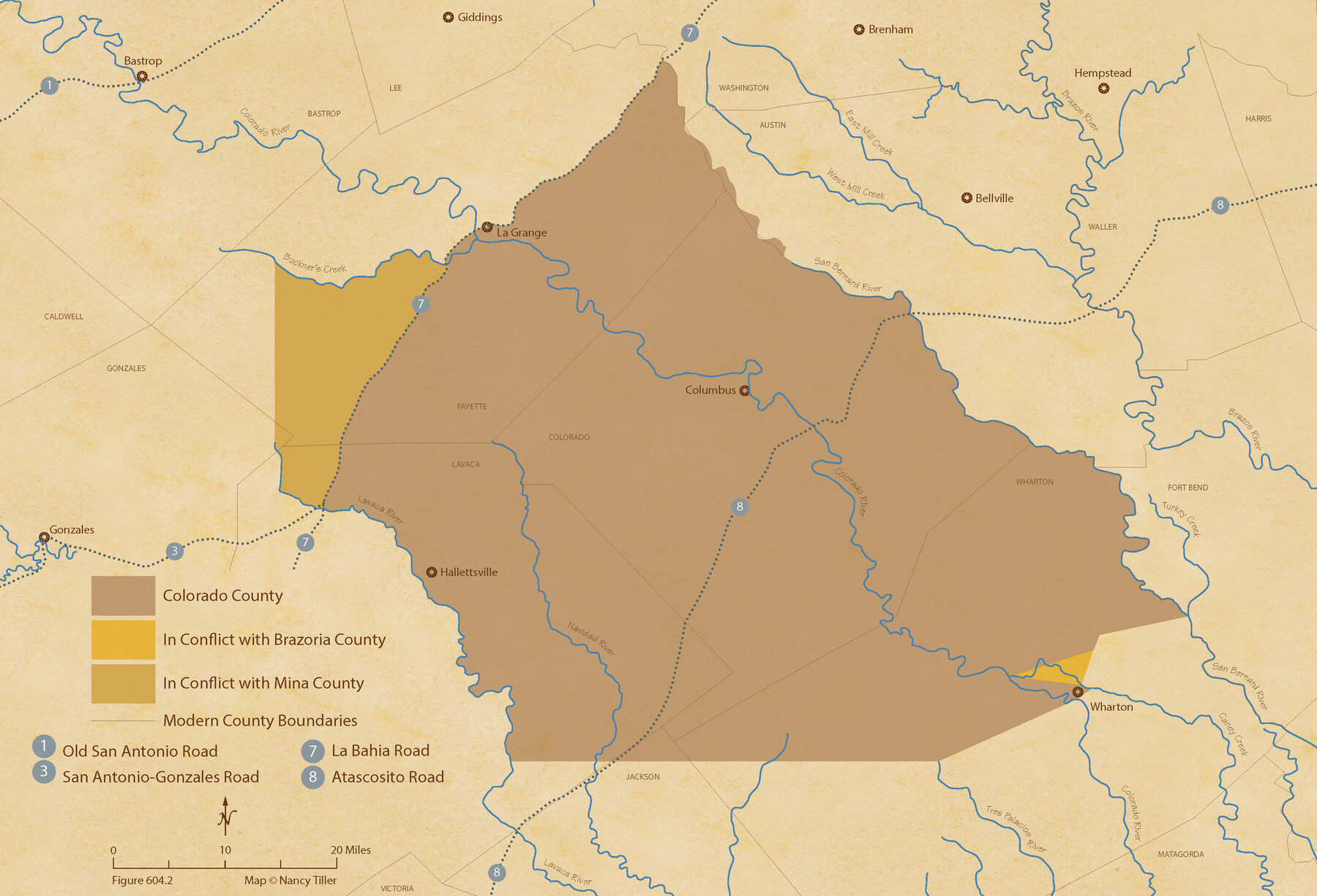
The Chief Justice County of Colorado. Lands in Conflict with Brazoria, Mina Counties
Figure No. 604.2 from 'A Boundary Atlas of Texas, 1821-1845' by Jim Tiller
-
Map/Doc
96045
-
Collection
Nancy and Jim Tiller Digital Collection
-
Object Dates
2020/1/1 (Creation Date)
-
People and Organizations
Jim Tiller (Author)
Nancy Tiller (Cartographer)
Gang Gong (GIS Professional)
-
Subjects
Atlas Republic of Texas Texas Boundaries
-
Height x Width
14.8 x 21.7 inches
37.6 x 55.1 cm
-
Medium
digital image
-
Comments
To purchase a digital PDF copy of "A Boundary Atlas of Texas, 1821-1845" see 96437.
Part of: Nancy and Jim Tiller Digital Collection
The Republic County of Shelby. Spring 1842

Print $20.00
The Republic County of Shelby. Spring 1842
2020
Size 20.0 x 21.7 inches
Map/Doc 96284
From Citizens of Shelby County for the Creation of a New County to be Called Caddo, April 7, 1838

Print $20.00
From Citizens of Shelby County for the Creation of a New County to be Called Caddo, April 7, 1838
2020
Size 25.5 x 21.7 inches
Map/Doc 96377
The Republic County of Jackson. December 24, 1844

Print $20.00
The Republic County of Jackson. December 24, 1844
2020
Size 15.6 x 21.8 inches
Map/Doc 96191
The Chief Justice County of Red River. Lands in Conflict with Nacogdoches County

Print $20.00
The Chief Justice County of Red River. Lands in Conflict with Nacogdoches County
2020
Size 17.4 x 21.8 inches
Map/Doc 96066
The Judicial District/County of Lavaca. Created, January 29, 1842

Print $20.00
The Judicial District/County of Lavaca. Created, January 29, 1842
2020
Size 14.6 x 21.7 inches
Map/Doc 96331
The Republic County of Harris. May 15, 1838

Print $20.00
The Republic County of Harris. May 15, 1838
2020
Size 17.7 x 21.7 inches
Map/Doc 96163
The Kennedy and Pringle Colony. February 15, 1842

Print $20.00
The Kennedy and Pringle Colony. February 15, 1842
2020
Size 23.0 x 17.7 inches
Map/Doc 96367
The Republic County of Travis. December 29, 1845

Print $20.00
The Republic County of Travis. December 29, 1845
2020
Size 20.8 x 21.6 inches
Map/Doc 96293
The Republic County of Austin. Defined, May 24, 1838

Print $20.00
The Republic County of Austin. Defined, May 24, 1838
2020
Size 14.7 x 21.6 inches
Map/Doc 96082
The Republic County of Bowie. January 8, 1844

Print $20.00
The Republic County of Bowie. January 8, 1844
2020
Size 19.5 x 21.7 inches
Map/Doc 96107
The Republic County of Montgomery. February 2, 1842

Print $20.00
The Republic County of Montgomery. February 2, 1842
2020
Size 19.9 x 21.7 inches
Map/Doc 96239
The Mexican Municipality of Jefferson. Defined, December 9, 1835

Print $20.00
The Mexican Municipality of Jefferson. Defined, December 9, 1835
2020
Size 15.5 x 21.7 inches
Map/Doc 96024
You may also like
Austin County Sketch File 8

Print $40.00
- Digital $50.00
Austin County Sketch File 8
1894
Size 19.3 x 19.9 inches
Map/Doc 10873
Submerged Lands of Texas, Brownsville-Harlingen Sheet

Print $20.00
- Digital $50.00
Submerged Lands of Texas, Brownsville-Harlingen Sheet
1978
Size 23.9 x 32.2 inches
Map/Doc 76129
Ward County Sketch File L

Print $20.00
- Digital $50.00
Ward County Sketch File L
Size 23.8 x 29.6 inches
Map/Doc 12601
Brewster County Working Sketch 46

Print $20.00
- Digital $50.00
Brewster County Working Sketch 46
1948
Size 37.6 x 33.6 inches
Map/Doc 67580
Young County Rolled Sketch 19

Print $20.00
- Digital $50.00
Young County Rolled Sketch 19
2021
Size 24.3 x 30.4 inches
Map/Doc 97023
Upton County Working Sketch 35

Print $20.00
- Digital $50.00
Upton County Working Sketch 35
1956
Size 42.8 x 30.5 inches
Map/Doc 69531
Harris County Sketch File 66

Print $20.00
- Digital $50.00
Harris County Sketch File 66
Size 16.9 x 27.5 inches
Map/Doc 11661
Haskell County Sketch File A

Print $4.00
- Digital $50.00
Haskell County Sketch File A
Size 7.8 x 11.9 inches
Map/Doc 26117
Map of McCulloch County

Print $20.00
- Digital $50.00
Map of McCulloch County
1858
Size 26.6 x 22.4 inches
Map/Doc 3855
Crockett County Sketch File 67

Print $20.00
- Digital $50.00
Crockett County Sketch File 67
1927
Size 30.1 x 26.6 inches
Map/Doc 11231
Bauer & Cockrell Lands Located in Martin County, Texas

Print $20.00
- Digital $50.00
Bauer & Cockrell Lands Located in Martin County, Texas
1908
Size 28.5 x 22.3 inches
Map/Doc 91365
Surveys in Austin's Colony along the east fork of Mill Creek

Print $20.00
- Digital $50.00
Surveys in Austin's Colony along the east fork of Mill Creek
1830
Size 23.7 x 12.6 inches
Map/Doc 208