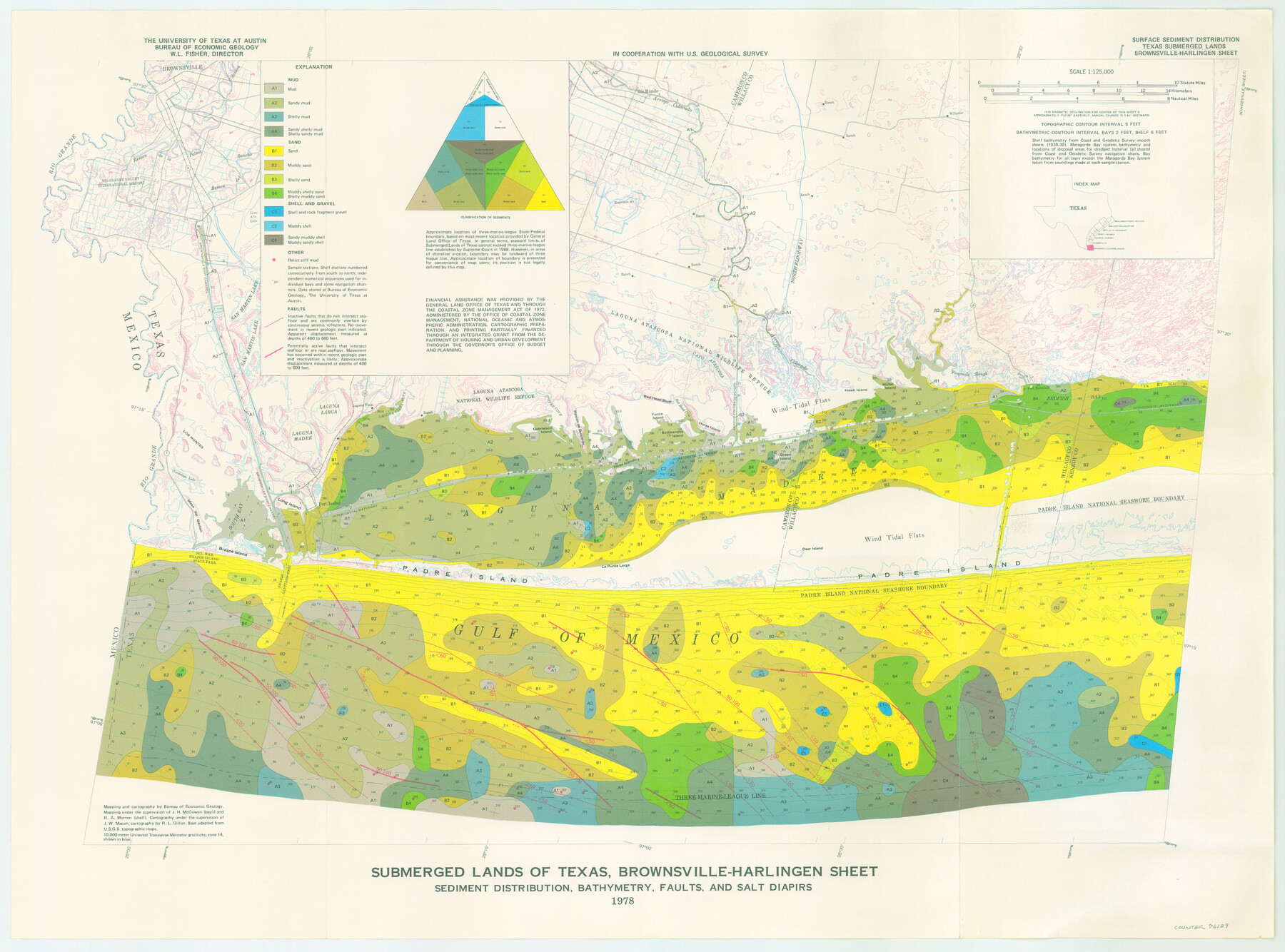
Submerged Lands of Texas, Brownsville-Harlingen Sheet
-
Map/Doc
76129
-
Collection
General Map Collection
-
Object Dates
1978 (Creation Date)
-
Subjects
Energy Offshore Submerged Area
-
Height x Width
23.9 x 32.2 inches
60.7 x 81.8 cm
Part of: General Map Collection
Liberty County Working Sketch 63

Print $20.00
- Digital $50.00
Liberty County Working Sketch 63
1969
Size 31.3 x 28.7 inches
Map/Doc 70523
Kimble County Working Sketch Graphic Index, Sheet 2 (Sketches 47 to Most Recent)

Print $40.00
- Digital $50.00
Kimble County Working Sketch Graphic Index, Sheet 2 (Sketches 47 to Most Recent)
1930
Size 41.1 x 49.0 inches
Map/Doc 76607
Briscoe County Working Sketch 12

Print $40.00
- Digital $50.00
Briscoe County Working Sketch 12
1984
Size 43.6 x 60.3 inches
Map/Doc 67815
Kenedy County Working Sketch 3

Print $20.00
- Digital $50.00
Kenedy County Working Sketch 3
1903
Size 30.3 x 38.4 inches
Map/Doc 70005
Callahan County

Print $20.00
- Digital $50.00
Callahan County
1879
Size 22.0 x 17.9 inches
Map/Doc 3362
Lubbock County Boundary File 9

Print $55.00
- Digital $50.00
Lubbock County Boundary File 9
Size 17.0 x 11.0 inches
Map/Doc 56530
Milam County Boundary File 6b

Print $40.00
- Digital $50.00
Milam County Boundary File 6b
Size 31.1 x 48.8 inches
Map/Doc 57249
Supreme Court of the United States, October Term, 1923, No. 15, Original - The State of Oklahoma, Complainant vs. The State of Texas, Defendant, The United States, Intervener; Report of the Boundary Commissioners

Print $20.00
- Digital $50.00
Supreme Court of the United States, October Term, 1923, No. 15, Original - The State of Oklahoma, Complainant vs. The State of Texas, Defendant, The United States, Intervener; Report of the Boundary Commissioners
1923
Size 34.4 x 40.6 inches
Map/Doc 75120
[Surveys in the Bexar District along the Sabinal and Frio Rivers]
![3167, [Surveys in the Bexar District along the Sabinal and Frio Rivers], General Map Collection](https://historictexasmaps.com/wmedia_w700/maps/3167.tif.jpg)
Print $20.00
- Digital $50.00
[Surveys in the Bexar District along the Sabinal and Frio Rivers]
1846
Size 16.8 x 19.6 inches
Map/Doc 3167
Township 10 North Range 14 West, North Western District, Louisiana

Print $20.00
- Digital $50.00
Township 10 North Range 14 West, North Western District, Louisiana
1854
Size 19.5 x 24.5 inches
Map/Doc 65872
Jim Hogg County Working Sketch 8

Print $40.00
- Digital $50.00
Jim Hogg County Working Sketch 8
1966
Size 82.7 x 40.0 inches
Map/Doc 66594
Presidio County Working Sketch 83

Print $20.00
- Digital $50.00
Presidio County Working Sketch 83
1969
Size 21.5 x 24.8 inches
Map/Doc 71760
You may also like
Hudspeth County Working Sketch 42

Print $20.00
- Digital $50.00
Hudspeth County Working Sketch 42
1981
Size 34.2 x 36.5 inches
Map/Doc 66327
Bandera County Working Sketch 51

Print $40.00
- Digital $50.00
Bandera County Working Sketch 51
1985
Size 49.8 x 44.3 inches
Map/Doc 67647
Montgomery County Sketch File 20

Print $38.00
- Digital $50.00
Montgomery County Sketch File 20
1932
Size 14.3 x 8.8 inches
Map/Doc 31847
Galveston County Rolled Sketch 13

Print $20.00
- Digital $50.00
Galveston County Rolled Sketch 13
1890
Size 34.5 x 24.2 inches
Map/Doc 5953
The Rand-McNally New Commercial Atlas Map of Texas

Print $20.00
The Rand-McNally New Commercial Atlas Map of Texas
1914
Size 42.7 x 28.6 inches
Map/Doc 78226
Knox County Sketch File 28

Print $20.00
- Digital $50.00
Knox County Sketch File 28
Size 43.4 x 38.3 inches
Map/Doc 10516
[Sketch showing Blocks 2B, 3B, 3T, IT and 2]
![91843, [Sketch showing Blocks 2B, 3B, 3T, IT and 2], Twichell Survey Records](https://historictexasmaps.com/wmedia_w700/maps/91843-1.tif.jpg)
Print $20.00
- Digital $50.00
[Sketch showing Blocks 2B, 3B, 3T, IT and 2]
1918
Size 32.9 x 30.1 inches
Map/Doc 91843
[Sketch for Mineral Application 16700 - Pecos River Bed]
![2806, [Sketch for Mineral Application 16700 - Pecos River Bed], General Map Collection](https://historictexasmaps.com/wmedia_w700/maps/2806.tif.jpg)
Print $20.00
- Digital $50.00
[Sketch for Mineral Application 16700 - Pecos River Bed]
1927
Size 20.3 x 29.1 inches
Map/Doc 2806
Right of Way and Track Map of The Missouri, Kansas & Texas Railway of Texas

Print $40.00
- Digital $50.00
Right of Way and Track Map of The Missouri, Kansas & Texas Railway of Texas
1918
Size 25.9 x 108.3 inches
Map/Doc 64526
Topographic Map, Low Rent Housing Project Texas 18-1, Housing Authority of the City of Lubbock (Plan No. 2)

Print $20.00
- Digital $50.00
Topographic Map, Low Rent Housing Project Texas 18-1, Housing Authority of the City of Lubbock (Plan No. 2)
1941
Size 42.4 x 27.2 inches
Map/Doc 92757
Map showing the John B. Pier Survey, Near Houston

Print $3.00
- Digital $50.00
Map showing the John B. Pier Survey, Near Houston
Size 11.9 x 17.8 inches
Map/Doc 478
Flight Mission No. DQN-4K, Frame 4, Calhoun County

Print $20.00
- Digital $50.00
Flight Mission No. DQN-4K, Frame 4, Calhoun County
1953
Size 18.8 x 22.3 inches
Map/Doc 84369