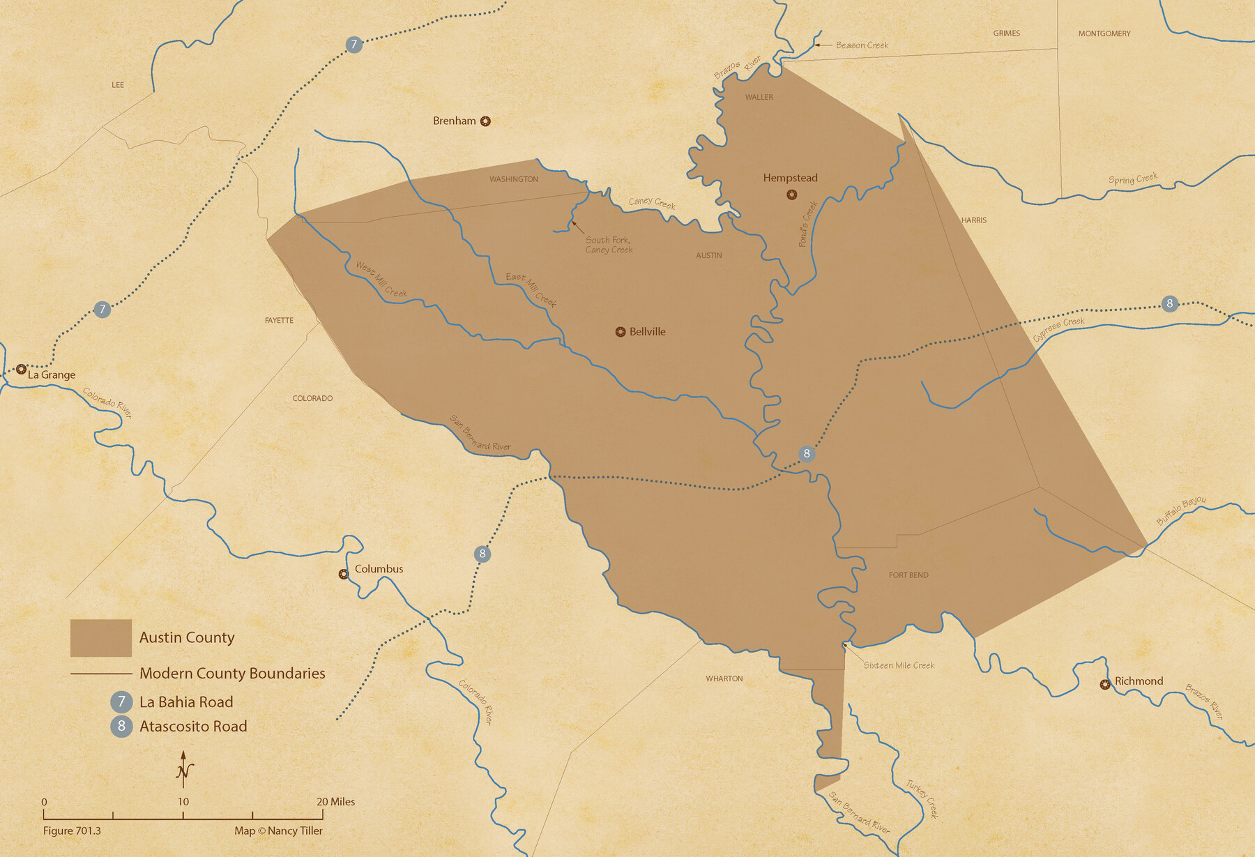
The Republic County of Austin. Defined, May 24, 1838
Figure No. 701.3 from 'A Boundary Atlas of Texas, 1821-1845' by Jim Tiller
-
Map/Doc
96082
-
Collection
Nancy and Jim Tiller Digital Collection
-
Object Dates
2020/1/1 (Creation Date)
-
People and Organizations
Jim Tiller (Author)
Nancy Tiller (Cartographer)
Gang Gong (GIS Professional)
-
Counties
Austin
-
Subjects
Atlas County Republic of Texas Texas Boundaries
-
Height x Width
14.7 x 21.6 inches
37.3 x 54.9 cm
-
Medium
digital image
-
Comments
To purchase a digital PDF copy of "A Boundary Atlas of Texas, 1821-1845" see 96437.
Part of: Nancy and Jim Tiller Digital Collection
The Chief Justice County of Colorado. Lands in Conflict with Brazoria, Mina Counties

Print $20.00
The Chief Justice County of Colorado. Lands in Conflict with Brazoria, Mina Counties
2020
Size 14.8 x 21.7 inches
Map/Doc 96045
The Mercer Colony. January 20, 1843

Print $20.00
The Mercer Colony. January 20, 1843
2020
Size 16.2 x 21.7 inches
Map/Doc 96360
The Republic County of Jackson. September 17, 1838

Print $20.00
The Republic County of Jackson. September 17, 1838
2020
Size 15.6 x 21.8 inches
Map/Doc 96185
From Citizens of Nacogdoches County Living East of the Trinity River and Along the Old San Antonio Road for the Creation of a New County (Unnamed), April 22, 1837

Print $20.00
From Citizens of Nacogdoches County Living East of the Trinity River and Along the Old San Antonio Road for the Creation of a New County (Unnamed), April 22, 1837
2020
Size 19.9 x 21.7 inches
Map/Doc 96374
The Republic County of Houston. December 29, 1845

Print $20.00
The Republic County of Houston. December 29, 1845
2020
Size 19.7 x 21.8 inches
Map/Doc 96183
The Mexican Municipality of Colorado. Created, January 11, 1836

Print $20.00
The Mexican Municipality of Colorado. Created, January 11, 1836
2020
Size 15.7 x 21.6 inches
Map/Doc 96019
From Citizens to Redefine the Boundary Between Gonzales and Victoria Counties, April 14, 18

Print $20.00
From Citizens to Redefine the Boundary Between Gonzales and Victoria Counties, April 14, 18
2020
Size 24.9 x 21.7 inches
Map/Doc 96378
The Republic County of Victoria. January 29, 1842

Print $20.00
The Republic County of Victoria. January 29, 1842
2020
Size 24.3 x 21.7 inches
Map/Doc 96298
The Mexican Municipality of Sabine. Created, December 15, 1835

Print $20.00
The Mexican Municipality of Sabine. Created, December 15, 1835
2020
Size 22.7 x 21.7 inches
Map/Doc 96031
The Republic County of Harris. December 29, 1845

Print $20.00
The Republic County of Harris. December 29, 1845
2020
Size 17.7 x 21.7 inches
Map/Doc 96168
The Mexican Department of Nacogdoches. On the Eve of Texas Independence, 1836

Print $20.00
The Mexican Department of Nacogdoches. On the Eve of Texas Independence, 1836
2020
Size 18.4 x 21.7 inches
Map/Doc 95974
The Chief Justice County of Jefferson. April 25, 1837

Print $20.00
The Chief Justice County of Jefferson. April 25, 1837
2020
Size 14.6 x 21.5 inches
Map/Doc 96054
You may also like
Bowie County Working Sketch 3

Print $20.00
- Digital $50.00
Bowie County Working Sketch 3
1913
Size 25.5 x 17.1 inches
Map/Doc 67407
Flight Mission No. CRC-1R, Frame 93, Chambers County

Print $20.00
- Digital $50.00
Flight Mission No. CRC-1R, Frame 93, Chambers County
1956
Size 18.7 x 22.6 inches
Map/Doc 84708
Flight Mission No. DQO-8K, Frame 89, Galveston County

Print $20.00
- Digital $50.00
Flight Mission No. DQO-8K, Frame 89, Galveston County
1952
Size 18.6 x 22.4 inches
Map/Doc 85191
Map of north end of Brazos Island

Print $20.00
- Digital $50.00
Map of north end of Brazos Island
Size 27.5 x 18.3 inches
Map/Doc 72906
Val Verde County Sketch File 4

Print $30.00
- Digital $50.00
Val Verde County Sketch File 4
1888
Size 28.0 x 20.6 inches
Map/Doc 12561
Erath County Working Sketch 50b

Print $20.00
- Digital $50.00
Erath County Working Sketch 50b
Size 43.4 x 25.8 inches
Map/Doc 69132

Photo Index of Texas Coast - Sheet 2 of 6

Print $20.00
- Digital $50.00
Photo Index of Texas Coast - Sheet 2 of 6
1954
Size 20.0 x 24.0 inches
Map/Doc 83439
Crockett County Rolled Sketch 88M

Print $20.00
- Digital $50.00
Crockett County Rolled Sketch 88M
1964
Size 25.2 x 34.2 inches
Map/Doc 5629
San Patricio County NRC Article 33.136 Sketch 1

Print $32.00
- Digital $50.00
San Patricio County NRC Article 33.136 Sketch 1
2001
Size 18.5 x 24.1 inches
Map/Doc 61623
Freestone County Working Sketch 6

Print $40.00
- Digital $50.00
Freestone County Working Sketch 6
1921
Size 38.3 x 60.0 inches
Map/Doc 69248
United States - Gulf Coast - Galveston to Rio Grande

Print $20.00
- Digital $50.00
United States - Gulf Coast - Galveston to Rio Grande
1940
Size 27.4 x 18.3 inches
Map/Doc 72757