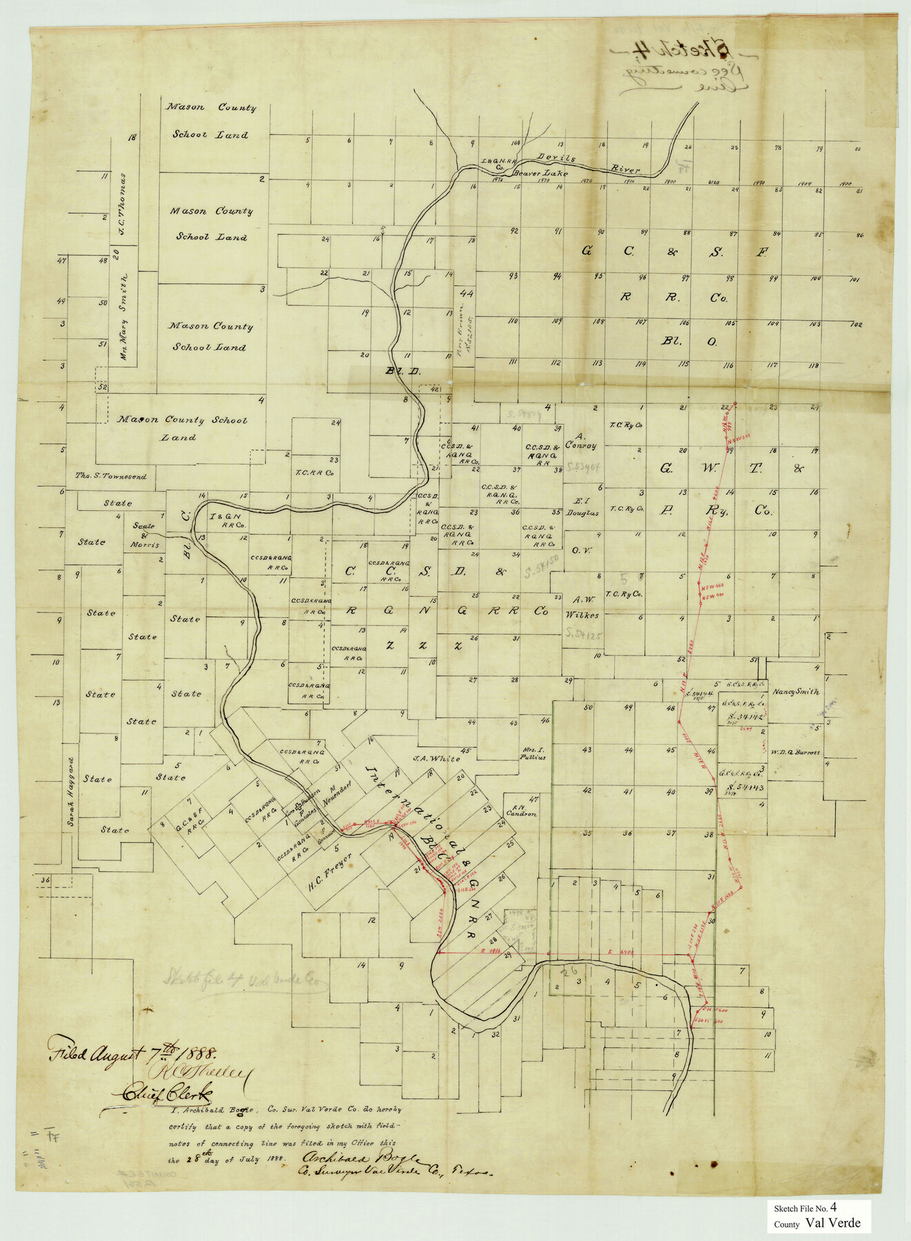
Val Verde County Sketch File 4
[Sketch and field notes of a connecting line from Camp Hudson to the mouth of Dolan Creek to the southwest corner of survey no. 117, Block E, G. C. & S. F. Ry. Co.]
-
Map/Doc
12561
-
Collection
General Map Collection
-
Object Dates
7/31/1888 (Creation Date)
8/7/1888 (File Date)
-
People and Organizations
Will H. Bonnell (Surveyor/Engineer)
Tom Kelley (Chainman/Field Personnel)
Jno. Lloyd (Chainman/Field Personnel)
P. Stockman (Chainman/Field Personnel)
-
Counties
Val Verde
-
Subjects
Surveying Sketch File
-
Height x Width
28.0 x 20.6 inches
71.1 x 52.3 cm
-
Medium
paper, manuscript
-
Features
Devil's River
Beaver Lake
Camp Hudson
Dolan Creek
Rio Grande
Soldier Camp
Part of: General Map Collection
Anderson County

Print $40.00
- Digital $50.00
Anderson County
1942
Size 52.9 x 47.9 inches
Map/Doc 66702
Map of Surveys Made for the T&PRRCo in Howard, Mitchell & Tom Green Counties, Blocks 27, 28, 29, 30, 31, 32 & 33, Reserve West of the Colorado

Print $40.00
- Digital $50.00
Map of Surveys Made for the T&PRRCo in Howard, Mitchell & Tom Green Counties, Blocks 27, 28, 29, 30, 31, 32 & 33, Reserve West of the Colorado
1876
Size 42.0 x 51.0 inches
Map/Doc 2228
Portion of States Submerged Area in Matagorda Bay

Print $20.00
- Digital $50.00
Portion of States Submerged Area in Matagorda Bay
1919
Size 16.8 x 17.2 inches
Map/Doc 2949
Wilson County Rolled Sketch 3

Print $20.00
- Digital $50.00
Wilson County Rolled Sketch 3
1956
Size 25.8 x 22.8 inches
Map/Doc 8369
Right of Way and Track Map International & Gt. Northern Ry. operated by the International & Gt. Northern Ry. Co., Columbia Branch, Gulf Division

Print $40.00
- Digital $50.00
Right of Way and Track Map International & Gt. Northern Ry. operated by the International & Gt. Northern Ry. Co., Columbia Branch, Gulf Division
1917
Size 25.1 x 56.7 inches
Map/Doc 64597
Callahan County Working Sketch 14

Print $20.00
- Digital $50.00
Callahan County Working Sketch 14
2010
Size 25.8 x 23.7 inches
Map/Doc 89273
Donley County Working Sketch 5

Print $40.00
- Digital $50.00
Donley County Working Sketch 5
Size 54.3 x 32.9 inches
Map/Doc 68738
Newton County

Print $40.00
- Digital $50.00
Newton County
1946
Size 48.7 x 41.9 inches
Map/Doc 66953
Presidio County Working Sketch 14

Print $20.00
- Digital $50.00
Presidio County Working Sketch 14
1942
Size 10.9 x 17.7 inches
Map/Doc 71690
Runnels County Rolled Sketch 37

Print $20.00
- Digital $50.00
Runnels County Rolled Sketch 37
Size 37.8 x 38.2 inches
Map/Doc 9870
No. 1 - Survey for a road from the Brazo Santiago to the Rio Grande

Print $20.00
- Digital $50.00
No. 1 - Survey for a road from the Brazo Santiago to the Rio Grande
1847
Size 18.3 x 27.2 inches
Map/Doc 72874
Kaufman County Sketch File 15

Print $26.00
- Digital $50.00
Kaufman County Sketch File 15
Size 8.5 x 8.2 inches
Map/Doc 28651
You may also like

Lynn County Sketch File 20

Print $4.00
- Digital $50.00
Lynn County Sketch File 20
1891
Size 8.8 x 10.9 inches
Map/Doc 30527
Fayette County Sketch File 4

Print $4.00
- Digital $50.00
Fayette County Sketch File 4
Size 11.7 x 7.9 inches
Map/Doc 22504
Oldham County Boundary File 1b

Print $48.00
- Digital $50.00
Oldham County Boundary File 1b
Size 14.0 x 8.5 inches
Map/Doc 57747
J. R. Jameson Farm

Print $3.00
- Digital $50.00
J. R. Jameson Farm
Size 10.8 x 13.5 inches
Map/Doc 92313
Burleson County

Print $20.00
- Digital $50.00
Burleson County
1920
Size 38.0 x 45.0 inches
Map/Doc 4790
Presidio County Sketch File 34

Print $4.00
- Digital $50.00
Presidio County Sketch File 34
1891
Size 14.3 x 8.7 inches
Map/Doc 34484
Upton County Sketch File 24

Print $4.00
- Digital $50.00
Upton County Sketch File 24
1928
Size 11.3 x 8.8 inches
Map/Doc 38879
Val Verde County Working Sketch 95

Print $20.00
- Digital $50.00
Val Verde County Working Sketch 95
1980
Size 26.5 x 31.8 inches
Map/Doc 72230
Flight Mission No. DIX-10P, Frame 165, Aransas County

Print $20.00
- Digital $50.00
Flight Mission No. DIX-10P, Frame 165, Aransas County
1956
Size 18.6 x 22.3 inches
Map/Doc 83955
Fisher County Sketch File 4

Print $33.00
- Digital $50.00
Fisher County Sketch File 4
Size 11.4 x 9.2 inches
Map/Doc 22557
Parker County Sketch File 5

Print $4.00
- Digital $50.00
Parker County Sketch File 5
1858
Size 8.1 x 8.2 inches
Map/Doc 33528