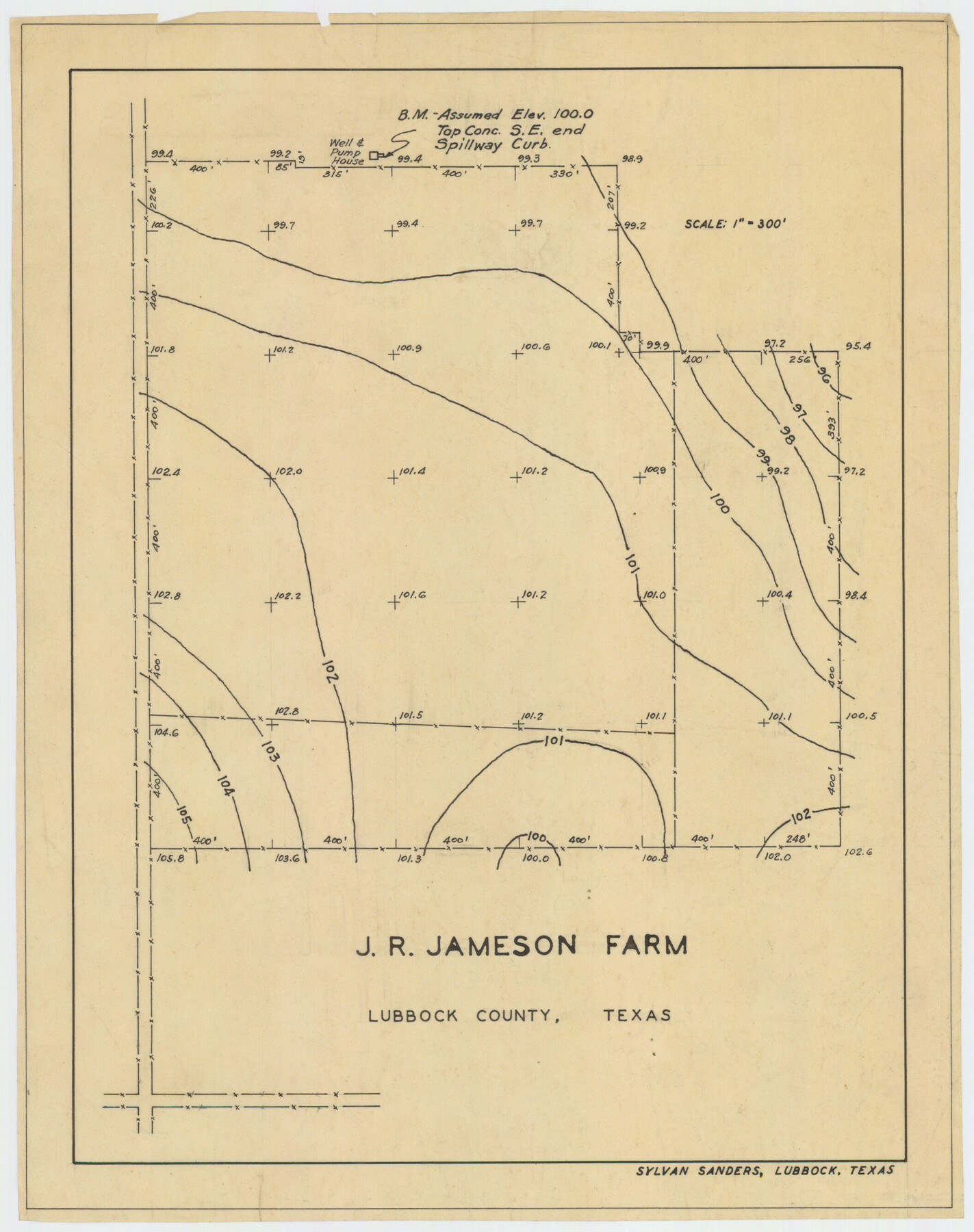
J. R. Jameson Farm
-
Map/Doc
92313
-
Collection
Twichell Survey Records
-
People and Organizations
Sylvan Sanders (Surveyor/Engineer)
-
Counties
Lubbock
-
Height x Width
10.8 x 13.5 inches
27.4 x 34.3 cm
Part of: Twichell Survey Records
Working Sketch in Childress County

Print $20.00
- Digital $50.00
Working Sketch in Childress County
1910
Size 6.6 x 23.3 inches
Map/Doc 90425
[Worksheets related to the Wilson Strickland survey and vicinity]
![89714, [Vicinity and related to the Wilson Strickland Survey], Twichell Survey Records](https://historictexasmaps.com/wmedia_w700/maps/89714-1.tif.jpg)
Print $20.00
- Digital $50.00
[Worksheets related to the Wilson Strickland survey and vicinity]
Size 40.9 x 43.1 inches
Map/Doc 89714
J. C. Landon's Subdivision of Sherman County School Land situated in Cochran Co., Texas

Print $20.00
- Digital $50.00
J. C. Landon's Subdivision of Sherman County School Land situated in Cochran Co., Texas
1925
Size 14.1 x 22.9 inches
Map/Doc 90291
[M. B. & B. Blks. A, B & C near Coyote Lake]
![90249, [M. B. & B. Blks. A, B & C near Coyote Lake], Twichell Survey Records](https://historictexasmaps.com/wmedia_w700/maps/90249-1.tif.jpg)
Print $20.00
- Digital $50.00
[M. B. & B. Blks. A, B & C near Coyote Lake]
Size 15.4 x 23.3 inches
Map/Doc 90249
[Blocks and surveys to the North and West of Jasper County School Land]
![91570, [Blocks and surveys to the North and West of Jasper County School Land], Twichell Survey Records](https://historictexasmaps.com/wmedia_w700/maps/91570-1.tif.jpg)
Print $20.00
- Digital $50.00
[Blocks and surveys to the North and West of Jasper County School Land]
Size 14.9 x 17.8 inches
Map/Doc 91570
A.W. Hudson Crosby County RR Line

Print $40.00
- Digital $50.00
A.W. Hudson Crosby County RR Line
Size 67.8 x 42.9 inches
Map/Doc 89760
Lovington Lea County, N. M. Lots 11, 14-Sec. 4-16-36

Print $40.00
- Digital $50.00
Lovington Lea County, N. M. Lots 11, 14-Sec. 4-16-36
Size 28.8 x 49.9 inches
Map/Doc 89694
[Sections 27 and 28, Block B-19]
![91857, [Sections 27 and 28, Block B-19], Twichell Survey Records](https://historictexasmaps.com/wmedia_w700/maps/91857-1.tif.jpg)
Print $2.00
- Digital $50.00
[Sections 27 and 28, Block B-19]
Size 14.6 x 9.1 inches
Map/Doc 91857
[Southeast Yoakum County, Southwest Terry County and North Gaines County]
![91876, [Southeast Yoakum County, Southwest Terry County and North Gaines County], Twichell Survey Records](https://historictexasmaps.com/wmedia_w700/maps/91876-1.tif.jpg)
Print $20.00
- Digital $50.00
[Southeast Yoakum County, Southwest Terry County and North Gaines County]
Size 20.7 x 16.6 inches
Map/Doc 91876
[Sections Surrounding Sections 111, 90, 112, 89]
![92131, [Sections Surrounding Sections 111, 90, 112, 89], Twichell Survey Records](https://historictexasmaps.com/wmedia_w700/maps/92131-1.tif.jpg)
Print $20.00
- Digital $50.00
[Sections Surrounding Sections 111, 90, 112, 89]
Size 15.5 x 26.2 inches
Map/Doc 92131
[T. & P. Block 36, Townships 1N - 5N]
![93132, [T. & P. Block 36, Townships 1N - 5N], Twichell Survey Records](https://historictexasmaps.com/wmedia_w700/maps/93132-1.tif.jpg)
Print $40.00
- Digital $50.00
[T. & P. Block 36, Townships 1N - 5N]
Size 21.3 x 87.8 inches
Map/Doc 93132
[West line of H. & T. C. RR. Block 97 and Blocks 29 and 30]
![90212, [West line of H. & T. C. RR. Block 97 and Blocks 29 and 30], Twichell Survey Records](https://historictexasmaps.com/wmedia_w700/maps/90212-1.tif.jpg)
Print $20.00
- Digital $50.00
[West line of H. & T. C. RR. Block 97 and Blocks 29 and 30]
Size 17.2 x 25.3 inches
Map/Doc 90212
You may also like
Houston County Working Sketch 4

Print $20.00
- Digital $50.00
Houston County Working Sketch 4
1911
Size 15.5 x 21.8 inches
Map/Doc 66234
Mileage Map of the Best Roads of Texas showing paved roads, road distances

Print $20.00
- Digital $50.00
Mileage Map of the Best Roads of Texas showing paved roads, road distances
1900
Size 21.7 x 28.7 inches
Map/Doc 95894
Nueces County Rolled Sketch 63A
Print $20.00
- Digital $50.00
Nueces County Rolled Sketch 63A
1979
Size 25.0 x 36.7 inches
Map/Doc 6910
Flight Mission No. DQN-2K, Frame 10, Calhoun County

Print $20.00
- Digital $50.00
Flight Mission No. DQN-2K, Frame 10, Calhoun County
1953
Size 18.5 x 22.0 inches
Map/Doc 84227
Hunt County Sketch File 12

Print $40.00
- Digital $50.00
Hunt County Sketch File 12
1852
Size 12.7 x 16.0 inches
Map/Doc 27104
[Leagues 1, 2, 281, 282, 284, and 285]
![92563, [Leagues 1, 2, 281, 282, 284, and 285], Twichell Survey Records](https://historictexasmaps.com/wmedia_w700/maps/92563-1.tif.jpg)
Print $20.00
- Digital $50.00
[Leagues 1, 2, 281, 282, 284, and 285]
Size 23.8 x 19.3 inches
Map/Doc 92563
Flight Mission No. DIX-6P, Frame 199, Aransas County

Print $20.00
- Digital $50.00
Flight Mission No. DIX-6P, Frame 199, Aransas County
1956
Size 18.8 x 22.6 inches
Map/Doc 83861
[Sketch for Mineral Application 15559 - Hutchinson County, Canadian River]
![65681, [Sketch for Mineral Application 15559 - Hutchinson County, Canadian River], General Map Collection](https://historictexasmaps.com/wmedia_w700/maps/65681-1.tif.jpg)
Print $20.00
- Digital $50.00
[Sketch for Mineral Application 15559 - Hutchinson County, Canadian River]
1926
Size 13.2 x 12.0 inches
Map/Doc 65681
Joe Bowman, Est. Irrigated Farm NW Quarter Section 11, Block E

Print $20.00
- Digital $50.00
Joe Bowman, Est. Irrigated Farm NW Quarter Section 11, Block E
1944
Size 16.4 x 18.5 inches
Map/Doc 92329
Flight Mission No. DQO-2K, Frame 93, Galveston County

Print $20.00
- Digital $50.00
Flight Mission No. DQO-2K, Frame 93, Galveston County
1952
Size 18.8 x 22.4 inches
Map/Doc 85020
Garza County Boundary File 1

Print $4.00
- Digital $50.00
Garza County Boundary File 1
Size 11.4 x 9.0 inches
Map/Doc 53671
Henderson County Rolled Sketch 11

Print $20.00
- Digital $50.00
Henderson County Rolled Sketch 11
1915
Size 28.9 x 42.6 inches
Map/Doc 76148