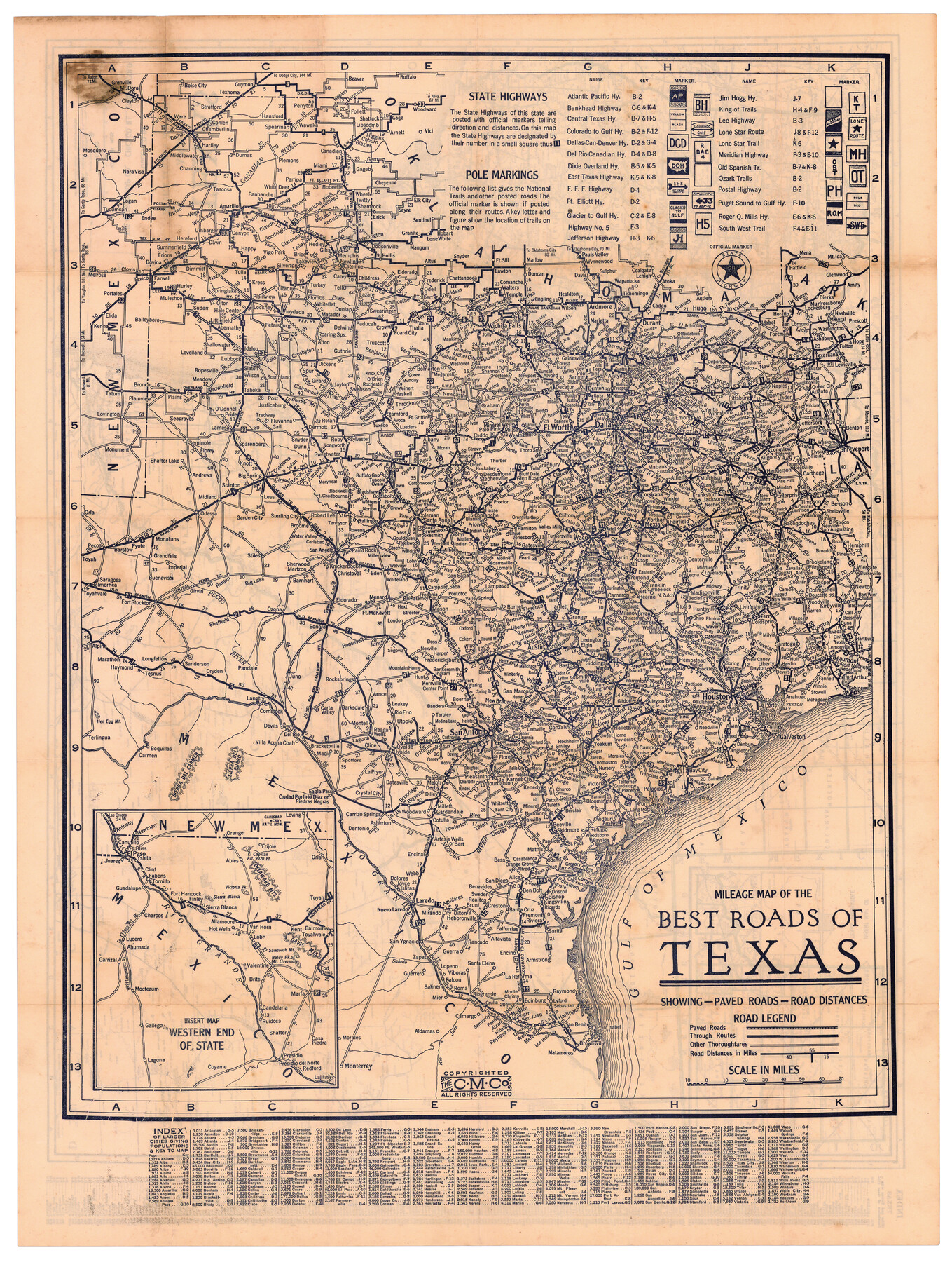
Mileage Map of the Best Roads of Texas showing paved roads, road distances
[Inset:] Western End of State
-
Map/Doc
95894
-
Collection
Cobb Digital Map Collection
-
Object Dates
[1900 ca.] (Creation Date)
-
Subjects
State of Texas
-
Height x Width
21.7 x 28.7 inches
55.1 x 72.9 cm
-
Medium
digital image
-
Comments
Courtesy of John & Diana Cobb.
To view map on verso, see 95895. For full booklet in which this map was contained, click "Download PDF" link above.
Related maps
Texas and Northern Mexico

Print $20.00
- Digital $50.00
Texas and Northern Mexico
1900
Size 21.6 x 28.6 inches
Map/Doc 95895
Part of: Cobb Digital Map Collection
Sectional map of Texas traversed by the Missouri, Kansas & Texas Railway, showing the crops adapted to each section, with the elevation and annual rainfall

Print $20.00
- Digital $50.00
Sectional map of Texas traversed by the Missouri, Kansas & Texas Railway, showing the crops adapted to each section, with the elevation and annual rainfall
Size 21.9 x 22.8 inches
Map/Doc 95818


![[San Benito Promotional Booklet]](https://historictexasmaps.com/wmedia_w700/pdf_converted_jpg/qi_pdf_thumbnail_64211.jpg)

A Little Journey through the Lower Valley of the Rio Grande - The Magic Valley of Texas

A Little Journey through the Lower Valley of the Rio Grande - The Magic Valley of Texas
1928
Map/Doc 96741
Galveston The Year-'Round Resort

Galveston The Year-'Round Resort
1912
Size 7.8 x 10.2 inches
Map/Doc 97058
The Lower Valley of the Rio Grande Irrigated Farm Lands

Print $20.00
- Digital $50.00
The Lower Valley of the Rio Grande Irrigated Farm Lands
1918
Size 24.6 x 18.6 inches
Map/Doc 96729
Correct Map of the Missouri, Kansas & Texas Railway and connections

Print $20.00
- Digital $50.00
Correct Map of the Missouri, Kansas & Texas Railway and connections
1895
Size 17.9 x 39.8 inches
Map/Doc 95808
Dinsmore & Company's New and Complete Map of the Railway System of the United States and Canada compiled from official sources, under the direction of the editor of the "American Railway Guide"

Print $20.00
- Digital $50.00
Dinsmore & Company's New and Complete Map of the Railway System of the United States and Canada compiled from official sources, under the direction of the editor of the "American Railway Guide"
1855
Size 16.3 x 20.4 inches
Map/Doc 95903
The Rand-McNally Official Railway Guide Map of the United States with portions of the Dominion of Canada, the Republic of Mexico, and the West Indies

Print $20.00
- Digital $50.00
The Rand-McNally Official Railway Guide Map of the United States with portions of the Dominion of Canada, the Republic of Mexico, and the West Indies
1927
Size 31.1 x 43.5 inches
Map/Doc 95864
Texas with population and location of principal towns and cities according to latest reliable statistics

Print $20.00
- Digital $50.00
Texas with population and location of principal towns and cities according to latest reliable statistics
1912
Size 19.0 x 21.2 inches
Map/Doc 95877
You may also like
Sterling County Rolled Sketch 23

Print $40.00
- Digital $50.00
Sterling County Rolled Sketch 23
Size 46.0 x 88.6 inches
Map/Doc 9954

San Patricio County Working Sketch 6

Print $40.00
- Digital $50.00
San Patricio County Working Sketch 6
1934
Size 44.0 x 87.3 inches
Map/Doc 63768
City of San Antonio, Texas

Print $20.00
City of San Antonio, Texas
1889
Size 34.2 x 34.1 inches
Map/Doc 76187
Uvalde County Rolled Sketch A

Print $20.00
- Digital $50.00
Uvalde County Rolled Sketch A
1849
Size 21.7 x 25.8 inches
Map/Doc 8104
Flight Mission No. BRA-7M, Frame 205, Jefferson County

Print $20.00
- Digital $50.00
Flight Mission No. BRA-7M, Frame 205, Jefferson County
1953
Size 18.5 x 22.4 inches
Map/Doc 85573
Van Zandt County Sketch File 40

Print $4.00
- Digital $50.00
Van Zandt County Sketch File 40
Size 8.6 x 9.4 inches
Map/Doc 39486
Cherokee County Sketch File 12

Print $4.00
- Digital $50.00
Cherokee County Sketch File 12
1860
Size 6.7 x 8.3 inches
Map/Doc 18140
Flight Mission No. CRC-2R, Frame 61, Chambers County

Print $20.00
- Digital $50.00
Flight Mission No. CRC-2R, Frame 61, Chambers County
1956
Size 18.8 x 22.5 inches
Map/Doc 84732
McLennan County Sketch File 6

Print $4.00
- Digital $50.00
McLennan County Sketch File 6
1850
Size 7.2 x 7.9 inches
Map/Doc 31244
[H. P. Fleming, J. E. Fitzgerald, J. R. Scott and surrounding surveys]
![90954, [H. P. Fleming, J. E. Fitzgerald, J. R. Scott and surrounding surveys], Twichell Survey Records](https://historictexasmaps.com/wmedia_w700/maps/90954-1.tif.jpg)
Print $20.00
- Digital $50.00
[H. P. Fleming, J. E. Fitzgerald, J. R. Scott and surrounding surveys]
Size 19.7 x 12.9 inches
Map/Doc 90954
Outer Continental Shelf Leasing Maps (Texas Offshore Operations)

Print $20.00
- Digital $50.00
Outer Continental Shelf Leasing Maps (Texas Offshore Operations)
Size 17.2 x 13.7 inches
Map/Doc 75842