Van Zandt County Sketch File 40
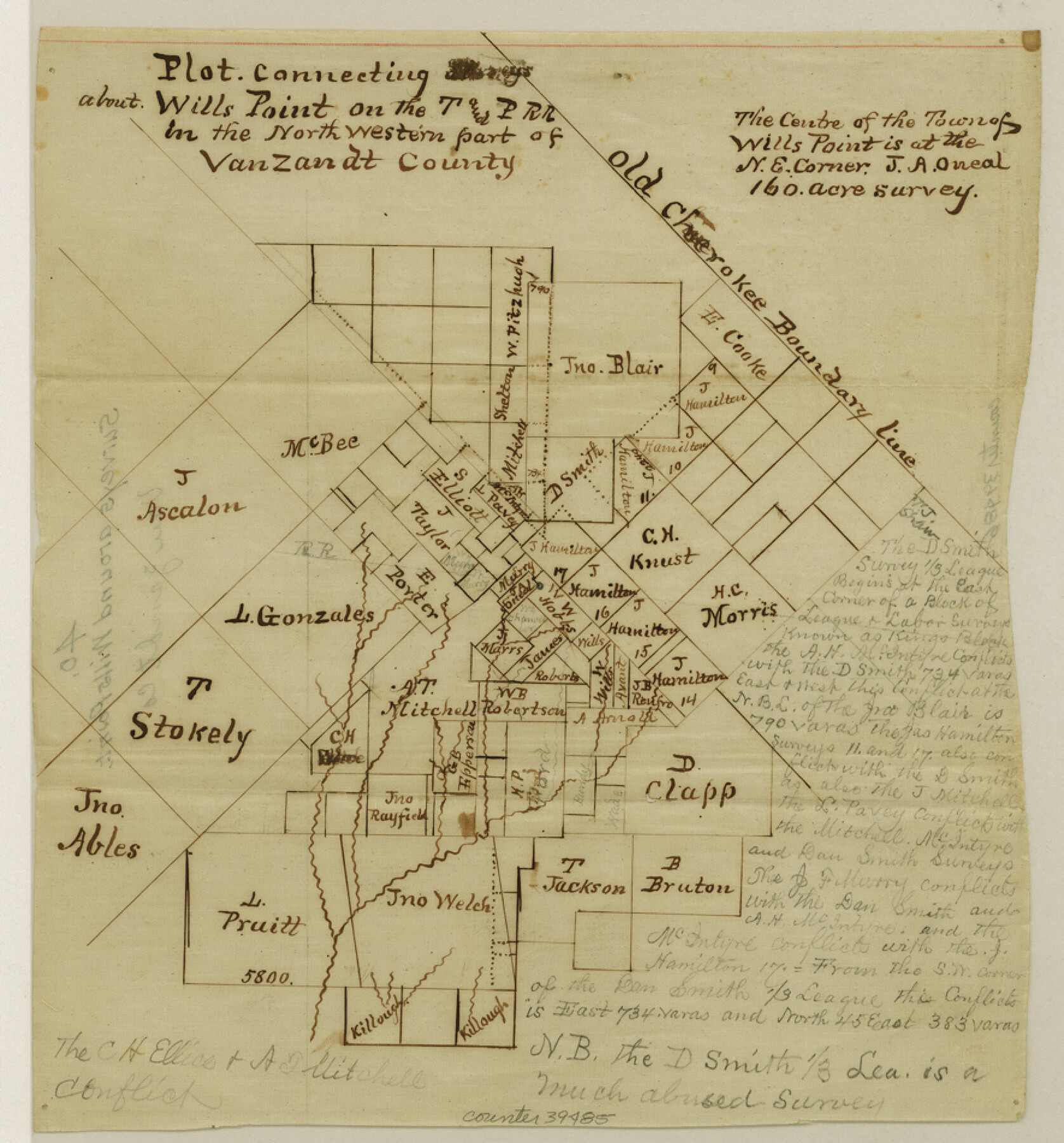
Plot connecting surveys about Wills Point on the T. & P. R.R. in the northwestern part of Van Zandt County
-
Map/Doc
39486
-
Collection
General Map Collection
-
People and Organizations
Thielepape (Draftsman)
-
Counties
Van Zandt
-
Subjects
Surveying Sketch File
-
Height x Width
8.6 x 9.4 inches
21.8 x 23.9 cm
-
Medium
paper, manuscript
-
Features
Wills Point
Part of: General Map Collection
Presidio County Working Sketch 150

Print $20.00
- Digital $50.00
Presidio County Working Sketch 150
2002
Size 24.0 x 23.5 inches
Map/Doc 93490
Reeves County Working Sketch 38

Print $20.00
- Digital $50.00
Reeves County Working Sketch 38
1971
Size 36.4 x 39.0 inches
Map/Doc 63481
Edwards County Working Sketch 132

Print $20.00
- Digital $50.00
Edwards County Working Sketch 132
1985
Size 37.1 x 37.1 inches
Map/Doc 69008
Henderson County

Print $40.00
- Digital $50.00
Henderson County
1922
Size 39.3 x 49.1 inches
Map/Doc 4683
Maps of Gulf Intracoastal Waterway, Texas - Sabine River to the Rio Grande and connecting waterways including ship channels

Print $20.00
- Digital $50.00
Maps of Gulf Intracoastal Waterway, Texas - Sabine River to the Rio Grande and connecting waterways including ship channels
1966
Size 14.5 x 22.1 inches
Map/Doc 61917
Red River County Working Sketch 13

Print $20.00
- Digital $50.00
Red River County Working Sketch 13
1947
Size 37.1 x 39.9 inches
Map/Doc 71996
Houston County Sketch File 2

Print $4.00
- Digital $50.00
Houston County Sketch File 2
1857
Size 12.6 x 7.9 inches
Map/Doc 26746
Leon County Rolled Sketch 13

Print $20.00
- Digital $50.00
Leon County Rolled Sketch 13
1975
Size 22.8 x 22.5 inches
Map/Doc 6600
Gregg County Rolled Sketch RGA

Print $46.00
- Digital $50.00
Gregg County Rolled Sketch RGA
1933
Size 34.3 x 30.6 inches
Map/Doc 9026
Henderson County Sketch File 23

Print $38.00
- Digital $50.00
Henderson County Sketch File 23
1956
Size 9.1 x 9.1 inches
Map/Doc 26372
Flight Mission No. CGI-3N, Frame 79, Cameron County

Print $20.00
- Digital $50.00
Flight Mission No. CGI-3N, Frame 79, Cameron County
1954
Size 18.6 x 22.4 inches
Map/Doc 84573
Flight Mission No. DAG-21K, Frame 96, Matagorda County

Print $20.00
- Digital $50.00
Flight Mission No. DAG-21K, Frame 96, Matagorda County
1952
Size 18.4 x 22.4 inches
Map/Doc 86425
You may also like
Flight Mission No. DQN-2K, Frame 89, Calhoun County

Print $20.00
- Digital $50.00
Flight Mission No. DQN-2K, Frame 89, Calhoun County
1953
Size 16.2 x 15.7 inches
Map/Doc 84279
Reeves County Rolled Sketch 2

Print $20.00
- Digital $50.00
Reeves County Rolled Sketch 2
1890
Size 34.0 x 39.5 inches
Map/Doc 9845
Bandera County Working Sketch 57

Print $20.00
- Digital $50.00
Bandera County Working Sketch 57
1991
Size 38.5 x 46.8 inches
Map/Doc 67653
Martin County Boundary File 3

Print $2.00
- Digital $50.00
Martin County Boundary File 3
Size 7.1 x 11.3 inches
Map/Doc 56781
Capitol Lands survey by J. T. Munson

Print $20.00
- Digital $50.00
Capitol Lands survey by J. T. Munson
Size 24.8 x 20.4 inches
Map/Doc 90585
Stonewall County Rolled Sketch 23

Print $20.00
- Digital $50.00
Stonewall County Rolled Sketch 23
Size 38.5 x 47.5 inches
Map/Doc 9962
Survey and Location of the Corpus Christi & Rio Grande Railway Under Charter of May 24th 1873

Print $40.00
- Digital $50.00
Survey and Location of the Corpus Christi & Rio Grande Railway Under Charter of May 24th 1873
1874
Size 12.5 x 58.7 inches
Map/Doc 64092
Block 2, John W. Jarrotts Subdivision

Print $20.00
- Digital $50.00
Block 2, John W. Jarrotts Subdivision
1950
Size 15.1 x 13.7 inches
Map/Doc 92713
Polk County Rolled Sketch 26

Print $20.00
- Digital $50.00
Polk County Rolled Sketch 26
Size 26.3 x 38.0 inches
Map/Doc 7314
Flight Mission No. DCL-6C, Frame 26, Kenedy County

Print $20.00
- Digital $50.00
Flight Mission No. DCL-6C, Frame 26, Kenedy County
1943
Size 18.7 x 22.5 inches
Map/Doc 85883
Nelson & White's Official Map of Beaumont

Print $40.00
Nelson & White's Official Map of Beaumont
1902
Size 54.3 x 39.4 inches
Map/Doc 93558
Childress County

Print $20.00
- Digital $50.00
Childress County
1884
Size 20.6 x 17.4 inches
Map/Doc 3395