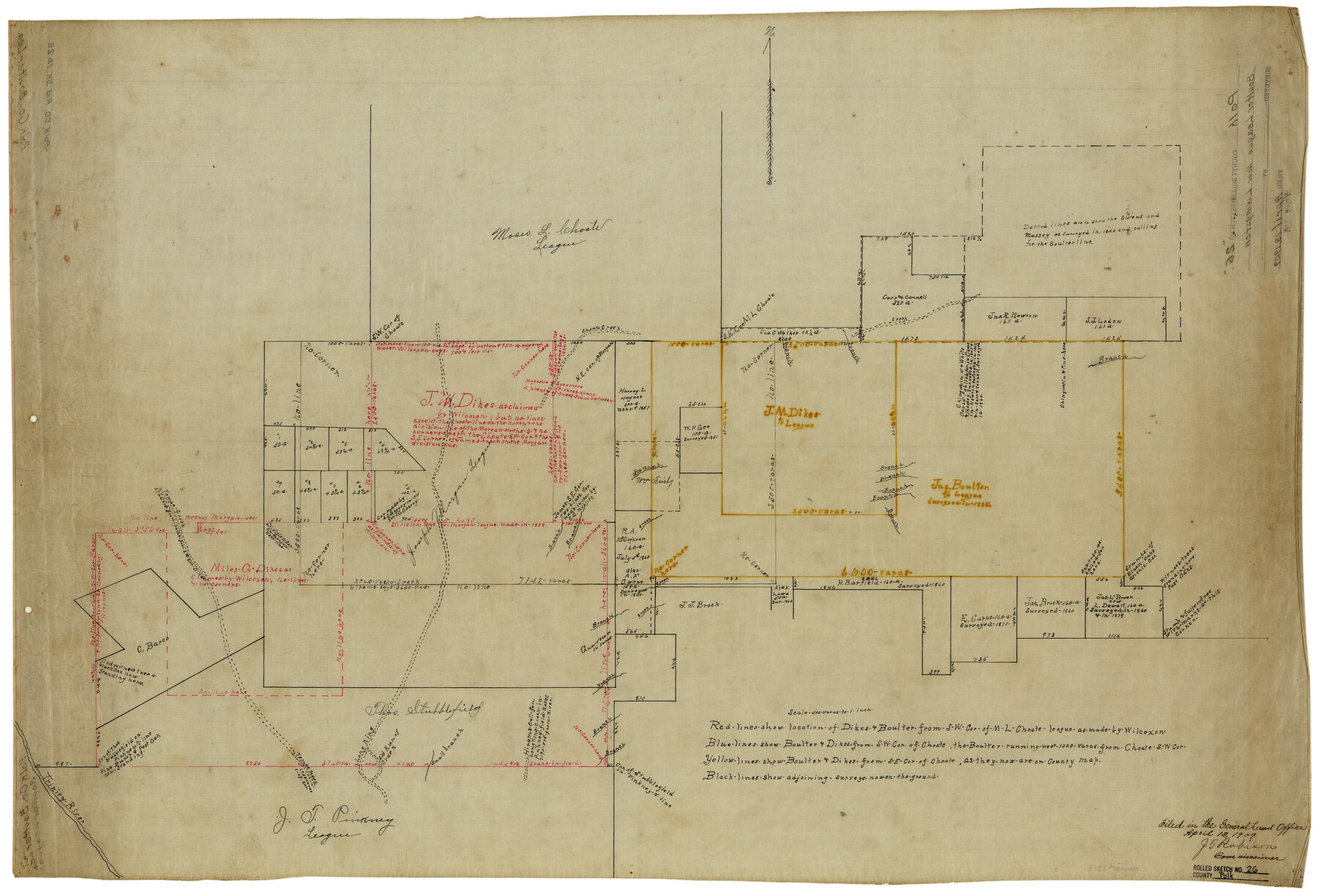
Polk County Rolled Sketch 26
[Sketch of area around the J. Dikes 1/4 league and Jas. Boulton 3/4 league surveys]
-
Map/Doc
7314
-
Collection
General Map Collection
-
Object Dates
4/13/1909 (File Date)
-
Counties
Polk
-
Subjects
Surveying Rolled Sketch
-
Height x Width
26.3 x 38.0 inches
66.8 x 96.5 cm
-
Medium
linen, manuscript
-
Scale
1" = 500 varas
Part of: General Map Collection
Pecos County Boundary File 69a

Print $40.00
- Digital $50.00
Pecos County Boundary File 69a
Size 8.4 x 9.7 inches
Map/Doc 57901
Wilbarger County Boundary File 1

Print $52.00
- Digital $50.00
Wilbarger County Boundary File 1
Size 8.9 x 5.6 inches
Map/Doc 59916
Shelby County Rolled Sketch 14

Print $20.00
- Digital $50.00
Shelby County Rolled Sketch 14
1948
Size 33.1 x 25.9 inches
Map/Doc 7782
Atascosa County Rolled Sketch 15

Print $20.00
- Digital $50.00
Atascosa County Rolled Sketch 15
1945
Size 45.2 x 42.7 inches
Map/Doc 8433
Map of Colorado District

Print $20.00
- Digital $50.00
Map of Colorado District
1841
Size 21.5 x 31.2 inches
Map/Doc 3421
Hemphill County

Print $20.00
- Digital $50.00
Hemphill County
1932
Size 39.5 x 37.5 inches
Map/Doc 77309
Jim Hogg County Sketch File 6

Print $20.00
- Digital $50.00
Jim Hogg County Sketch File 6
1939
Size 17.9 x 19.6 inches
Map/Doc 11886
Jack County Sketch File 18b

Print $4.00
- Digital $50.00
Jack County Sketch File 18b
Size 8.0 x 12.9 inches
Map/Doc 27557
Galveston County Sketch File 67

Print $4.00
- Digital $50.00
Galveston County Sketch File 67
1988
Size 11.3 x 8.7 inches
Map/Doc 23782
Throckmorton County Working Sketch Graphic Index

Print $20.00
- Digital $50.00
Throckmorton County Working Sketch Graphic Index
1943
Size 44.6 x 36.3 inches
Map/Doc 76713
Prison Property, Walker Co.

Print $20.00
- Digital $50.00
Prison Property, Walker Co.
Size 24.4 x 23.5 inches
Map/Doc 62976
Flight Mission No. BRA-6M, Frame 153, Jefferson County

Print $20.00
- Digital $50.00
Flight Mission No. BRA-6M, Frame 153, Jefferson County
1953
Size 18.5 x 22.2 inches
Map/Doc 85454
You may also like
Flight Mission No. CGI-1N, Frame 170, Cameron County

Print $20.00
- Digital $50.00
Flight Mission No. CGI-1N, Frame 170, Cameron County
1955
Size 18.5 x 22.1 inches
Map/Doc 84505
Kent County Sketch File 8

Print $20.00
- Digital $50.00
Kent County Sketch File 8
Size 19.0 x 40.8 inches
Map/Doc 10515
Val Verde County Working Sketch 96

Print $20.00
- Digital $50.00
Val Verde County Working Sketch 96
1979
Size 38.9 x 36.9 inches
Map/Doc 72231
Kerr County Boundary File 3

Print $6.00
- Digital $50.00
Kerr County Boundary File 3
Size 11.3 x 8.8 inches
Map/Doc 55998
Jno. W. Pritchett Preliminary Official LO Map for Lubbock [County]
![89901, Jno. W. Pritchett Preliminary Official LO Map for Lubbock [County], Twichell Survey Records](https://historictexasmaps.com/wmedia_w700/maps/89901-1.tif.jpg)
Print $20.00
- Digital $50.00
Jno. W. Pritchett Preliminary Official LO Map for Lubbock [County]
Size 41.1 x 40.3 inches
Map/Doc 89901
San Augustine County Working Sketch 4

Print $20.00
- Digital $50.00
San Augustine County Working Sketch 4
1934
Size 24.4 x 27.7 inches
Map/Doc 63691
Flight Mission No. DAG-24K, Frame 54, Matagorda County

Print $20.00
- Digital $50.00
Flight Mission No. DAG-24K, Frame 54, Matagorda County
1953
Size 17.2 x 19.1 inches
Map/Doc 86541
Clay County Sketch File 23

Print $4.00
- Digital $50.00
Clay County Sketch File 23
Size 18.9 x 23.0 inches
Map/Doc 11086
McMullen County Working Sketch 27

Print $40.00
- Digital $50.00
McMullen County Working Sketch 27
1953
Size 53.2 x 32.9 inches
Map/Doc 70728
Taylor County Sketch File 21

Print $10.00
- Digital $50.00
Taylor County Sketch File 21
1962
Size 11.3 x 8.8 inches
Map/Doc 37821
Map of Runnels County

Print $20.00
- Digital $50.00
Map of Runnels County
1867
Size 27.3 x 19.3 inches
Map/Doc 4003
Kleberg County Rolled Sketch 10-6

Print $20.00
- Digital $50.00
Kleberg County Rolled Sketch 10-6
1951
Size 38.0 x 39.1 inches
Map/Doc 9399