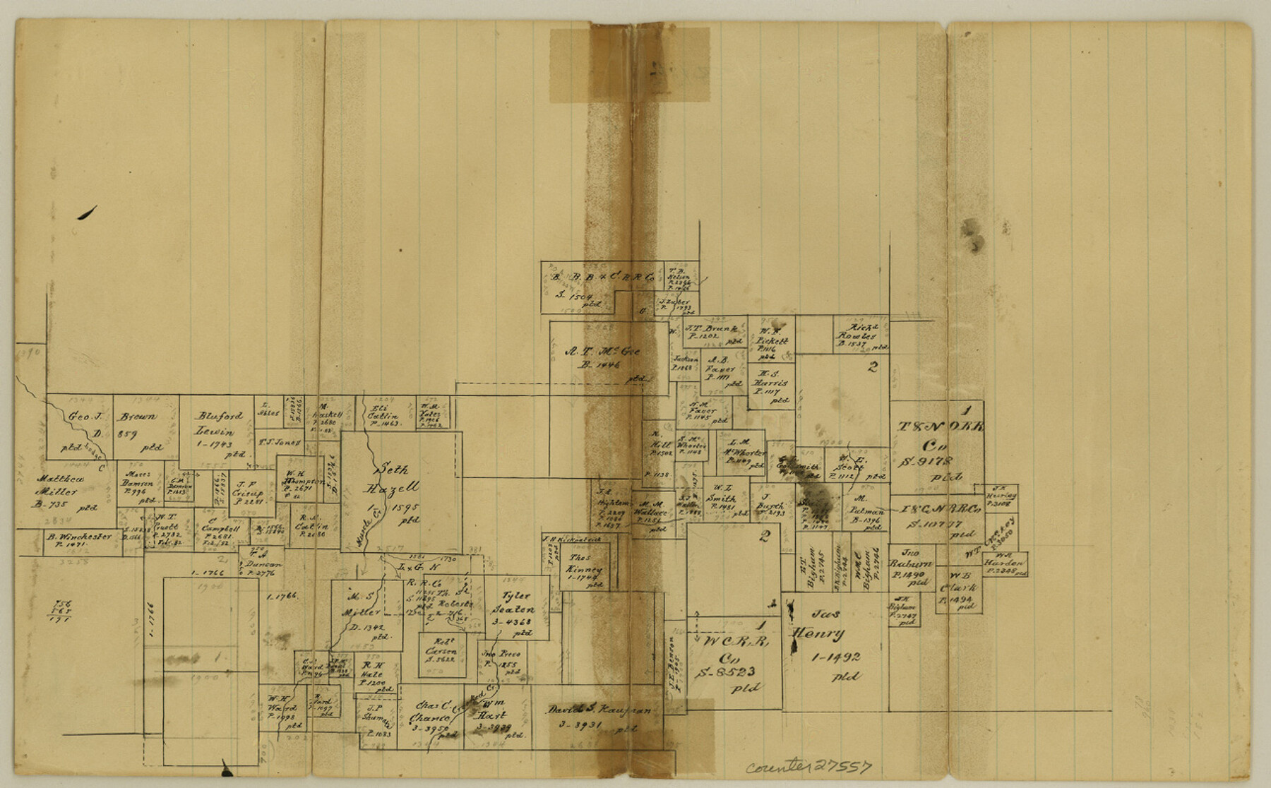
Jack County Sketch File 18b
[Sketch around the Seth Hazell survey]
-
Map/Doc
27557
-
Collection
General Map Collection
-
Counties
Jack
-
Subjects
Surveying Sketch File
-
Height x Width
8.0 x 12.9 inches
20.3 x 32.8 cm
-
Medium
paper, manuscript
-
Features
Muscle Creek
Crooked Creek
Lodge Creek
Part of: General Map Collection
Jefferson County Rolled Sketch 43

Print $40.00
- Digital $50.00
Jefferson County Rolled Sketch 43
1957
Size 50.1 x 18.2 inches
Map/Doc 9303
Lee County Sketch File 5

Print $40.00
- Digital $50.00
Lee County Sketch File 5
Size 12.2 x 15.8 inches
Map/Doc 29686

Gradient Boundary Survey of Canadian River through portions of Hutchinson & Roberts Counties, Texas

Print $40.00
- Digital $50.00
Gradient Boundary Survey of Canadian River through portions of Hutchinson & Roberts Counties, Texas
1989
Size 39.6 x 139.0 inches
Map/Doc 3120
Gaines County Sketch File 13

Print $40.00
- Digital $50.00
Gaines County Sketch File 13
1954
Size 8.9 x 20.4 inches
Map/Doc 23200
Angelina County Sketch File 16

Print $11.00
- Digital $50.00
Angelina County Sketch File 16
Size 7.9 x 3.8 inches
Map/Doc 13004
Runnels County Rolled Sketch 51

Print $20.00
- Digital $50.00
Runnels County Rolled Sketch 51
Size 26.1 x 34.3 inches
Map/Doc 7536
[Portion of Harris County]
![78482, [Portion of Harris County], General Map Collection](https://historictexasmaps.com/wmedia_w700/maps/78482.tif.jpg)
Print $2.00
- Digital $50.00
[Portion of Harris County]
Size 9.8 x 7.2 inches
Map/Doc 78482
Hidalgo County Sketch File 9

Print $40.00
- Digital $50.00
Hidalgo County Sketch File 9
1904
Size 8.8 x 5.7 inches
Map/Doc 26409
Sabine Pass, Texas

Print $40.00
- Digital $50.00
Sabine Pass, Texas
1874
Size 32.2 x 53.2 inches
Map/Doc 69837
Flight Mission No. DCL-7C, Frame 113, Kenedy County

Print $20.00
- Digital $50.00
Flight Mission No. DCL-7C, Frame 113, Kenedy County
1943
Size 18.5 x 22.2 inches
Map/Doc 86078
Brewster County Sketch File N-14

Print $24.00
- Digital $50.00
Brewster County Sketch File N-14
1938
Size 14.4 x 8.9 inches
Map/Doc 15629
You may also like
[CTRR Co. Block T, Cottle County, Texas]
![10777, [CTRR Co. Block T, Cottle County, Texas], Maddox Collection](https://historictexasmaps.com/wmedia_w700/maps/10777.tif.jpg)
Print $20.00
- Digital $50.00
[CTRR Co. Block T, Cottle County, Texas]
Size 21.5 x 14.0 inches
Map/Doc 10777
Northwest Part Crockett County

Print $40.00
- Digital $50.00
Northwest Part Crockett County
1983
Size 37.3 x 48.3 inches
Map/Doc 95470
Map of McCulloch County

Print $20.00
- Digital $50.00
Map of McCulloch County
1874
Size 26.7 x 20.7 inches
Map/Doc 3857
[Blocks C22, C23, C24, 77, B3, B5, 26, 27, 74, 75]
![91973, [Blocks C22, C23, C24, 77, B3, B5, 26, 27, 74, 75], Twichell Survey Records](https://historictexasmaps.com/wmedia_w700/maps/91973-1.tif.jpg)
Print $20.00
- Digital $50.00
[Blocks C22, C23, C24, 77, B3, B5, 26, 27, 74, 75]
Size 21.9 x 16.9 inches
Map/Doc 91973
Flight Mission No. CUG-3P, Frame 38, Kleberg County

Print $20.00
- Digital $50.00
Flight Mission No. CUG-3P, Frame 38, Kleberg County
1956
Size 18.5 x 22.3 inches
Map/Doc 86243
Wise County Sketch File 19

Print $4.00
- Digital $50.00
Wise County Sketch File 19
1857
Size 11.0 x 8.2 inches
Map/Doc 40555
Laguna Madre from Lone Palmetto Triangulation Station to Gum Pen Triangulation Station

Print $20.00
- Digital $50.00
Laguna Madre from Lone Palmetto Triangulation Station to Gum Pen Triangulation Station
1881
Size 16.2 x 27.5 inches
Map/Doc 73497
Crockett County Rolled Sketch 30

Print $20.00
- Digital $50.00
Crockett County Rolled Sketch 30
1934
Size 24.5 x 43.1 inches
Map/Doc 8700

Flight Mission No. BRE-3P, Frame 79, Nueces County

Print $20.00
- Digital $50.00
Flight Mission No. BRE-3P, Frame 79, Nueces County
1956
Size 18.6 x 22.5 inches
Map/Doc 86820
Brazos River, Brazos River Sheet 5

Print $20.00
- Digital $50.00
Brazos River, Brazos River Sheet 5
1926
Size 27.4 x 21.7 inches
Map/Doc 69669
Parker County Sketch File 1a

Print $2.00
- Digital $50.00
Parker County Sketch File 1a
1859
Size 8.6 x 5.5 inches
Map/Doc 33518