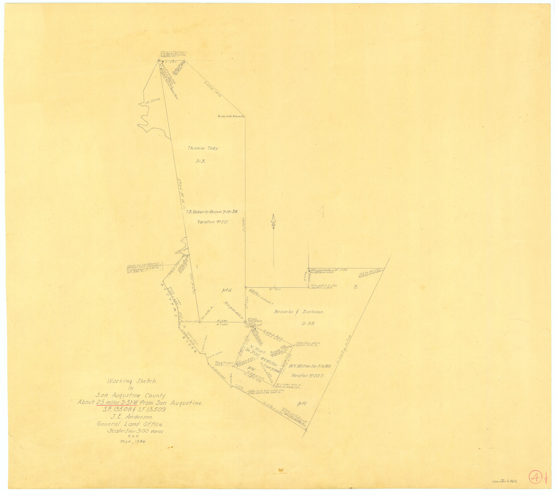
San Augustine County Working Sketch 4
-
Map/Doc
63691
-
Collection
General Map Collection
-
Object Dates
9/1934 (Creation Date)
-
Counties
San Augustine
-
Subjects
Surveying Working Sketch
-
Height x Width
24.4 x 27.7 inches
62.0 x 70.4 cm
-
Scale
1" = 300 varas
Part of: General Map Collection
Collin County Sketch File 2

Print $8.00
- Digital $50.00
Collin County Sketch File 2
1848
Size 10.0 x 8.0 inches
Map/Doc 18858
Harris County Historic Topographic 24

Print $20.00
- Digital $50.00
Harris County Historic Topographic 24
1916
Size 29.2 x 22.9 inches
Map/Doc 65835
Trinity River, Big Creek Sheet

Print $40.00
- Digital $50.00
Trinity River, Big Creek Sheet
1924
Size 48.0 x 36.4 inches
Map/Doc 65179
Current Miscellaneous File 97

Print $16.00
- Digital $50.00
Current Miscellaneous File 97
1847
Size 11.3 x 8.8 inches
Map/Doc 74329
Aransas Pass to Baffin Bay

Print $20.00
- Digital $50.00
Aransas Pass to Baffin Bay
1946
Size 42.1 x 34.3 inches
Map/Doc 73412
Maverick County Working Sketch 7

Print $20.00
- Digital $50.00
Maverick County Working Sketch 7
1959
Size 22.4 x 21.0 inches
Map/Doc 70899
Uvalde County Working Sketch 43

Print $20.00
- Digital $50.00
Uvalde County Working Sketch 43
1978
Size 29.3 x 27.7 inches
Map/Doc 72113
Flight Mission No. BQY-15M, Frame 17, Harris County

Print $20.00
- Digital $50.00
Flight Mission No. BQY-15M, Frame 17, Harris County
1953
Size 18.5 x 22.2 inches
Map/Doc 85315
Travis County State Real Property Sketch 14

Print $40.00
- Digital $50.00
Travis County State Real Property Sketch 14
1995
Size 18.1 x 23.9 inches
Map/Doc 61672
Coleman County Working Sketch 11

Print $20.00
- Digital $50.00
Coleman County Working Sketch 11
1950
Size 24.2 x 18.2 inches
Map/Doc 68077
Montgomery County Rolled Sketch 10

Print $20.00
- Digital $50.00
Montgomery County Rolled Sketch 10
1905
Size 35.5 x 26.2 inches
Map/Doc 6796
Concho County Sketch File 50

Print $20.00
- Digital $50.00
Concho County Sketch File 50
1890
Size 15.9 x 13.6 inches
Map/Doc 19217
You may also like
Flight Mission No. CUG-1P, Frame 27, Kleberg County

Print $20.00
- Digital $50.00
Flight Mission No. CUG-1P, Frame 27, Kleberg County
1956
Size 18.4 x 22.1 inches
Map/Doc 86117
Section L Tech Memorial Park, Inc.

Print $20.00
- Digital $50.00
Section L Tech Memorial Park, Inc.
1950
Size 17.7 x 19.5 inches
Map/Doc 92350
Edwards County Sketch File 18

Print $6.00
- Digital $50.00
Edwards County Sketch File 18
Size 16.3 x 10.6 inches
Map/Doc 21738
Harris County Rolled Sketch 88

Print $20.00
- Digital $50.00
Harris County Rolled Sketch 88
1935
Size 34.4 x 23.0 inches
Map/Doc 6121
Map of South Louisiana and Louisiana Continental Shelf showing Natural Gas Pipe Lines

Print $40.00
- Digital $50.00
Map of South Louisiana and Louisiana Continental Shelf showing Natural Gas Pipe Lines
Size 40.0 x 56.0 inches
Map/Doc 75906
Crockett County Rolled Sketch 30

Print $20.00
- Digital $50.00
Crockett County Rolled Sketch 30
1934
Size 24.5 x 43.1 inches
Map/Doc 8700
Atascosa County Sketch File 37

Print $40.00
- Digital $50.00
Atascosa County Sketch File 37
Size 17.6 x 12.9 inches
Map/Doc 13829
The Republic County of Milam. December 31, 1838

Print $20.00
The Republic County of Milam. December 31, 1838
2020
Size 17.4 x 21.6 inches
Map/Doc 96227
Flight Mission No. CLL-1N, Frame 197, Willacy County

Print $20.00
- Digital $50.00
Flight Mission No. CLL-1N, Frame 197, Willacy County
1954
Size 18.4 x 22.1 inches
Map/Doc 87067
La Salle County Working Sketch 13

Print $20.00
- Digital $50.00
La Salle County Working Sketch 13
1930
Size 36.2 x 40.3 inches
Map/Doc 70314
United States Great Lakes and adjacent waterways

Print $20.00
- Digital $50.00
United States Great Lakes and adjacent waterways
Size 20.8 x 42.7 inches
Map/Doc 76122
Wise County Rolled Sketch 9

Print $20.00
- Digital $50.00
Wise County Rolled Sketch 9
Size 35.2 x 24.2 inches
Map/Doc 93640