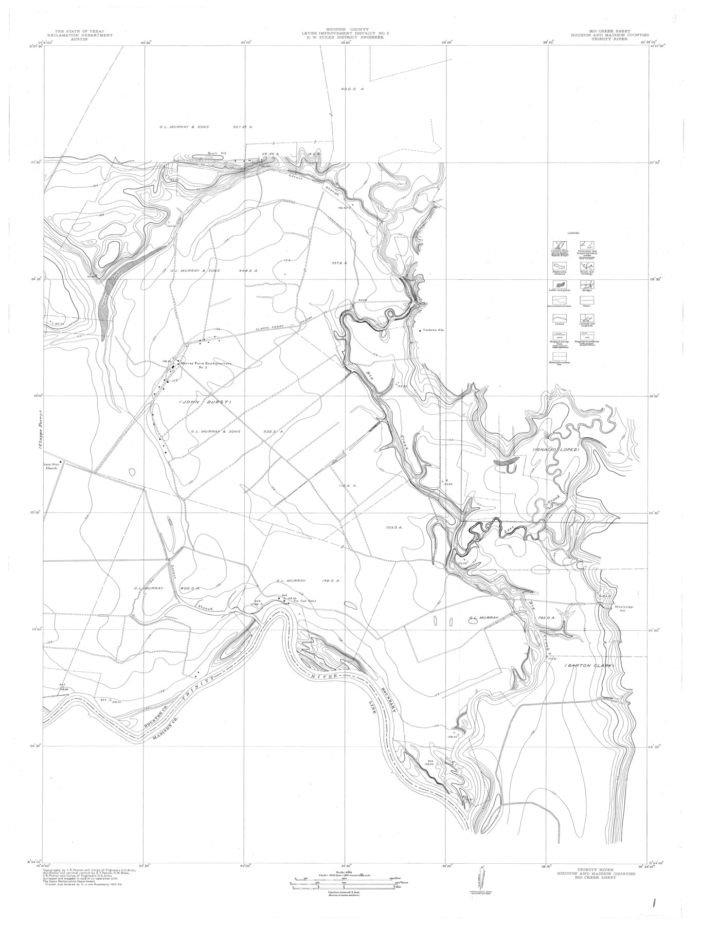
Trinity River, Big Creek Sheet
-
Map/Doc
65179
-
Collection
General Map Collection
-
Object Dates
1924 (Creation Date)
-
People and Organizations
Texas State Reclamation Department (Publisher)
E.J. von Rosenberg (Compiler)
E.J. von Rosenberg (Draftsman)
F.R. Poston (Surveyor/Engineer)
R.W. Stiles (Surveyor/Engineer)
S.T. Penick (Surveyor/Engineer)
-
Counties
Houston Madison
-
Subjects
River Surveys Topographic
-
Height x Width
48.0 x 36.4 inches
121.9 x 92.5 cm
-
Comments
Big Creek Sheet located east of the Clapps Ferry Sheet.
Part of: General Map Collection

Maps of Gulf Intracoastal Waterway, Texas - Sabine River to the Rio Grande and connecting waterways including ship channels

Print $20.00
- Digital $50.00
Maps of Gulf Intracoastal Waterway, Texas - Sabine River to the Rio Grande and connecting waterways including ship channels
1966
Size 14.6 x 22.2 inches
Map/Doc 61945
Gray County Working Sketch 1

Print $40.00
- Digital $50.00
Gray County Working Sketch 1
Size 121.0 x 38.8 inches
Map/Doc 63232
Tyler County Working Sketch 1

Print $20.00
- Digital $50.00
Tyler County Working Sketch 1
1911
Size 19.0 x 15.0 inches
Map/Doc 69471
Navarro County Sketch File 13

Print $22.00
- Digital $50.00
Navarro County Sketch File 13
Size 12.0 x 8.6 inches
Map/Doc 32324
Mitchell County Boundary File 1

Print $38.00
- Digital $50.00
Mitchell County Boundary File 1
Size 9.1 x 8.4 inches
Map/Doc 57334
Goliad County Sketch File X

Print $10.00
- Digital $50.00
Goliad County Sketch File X
1893
Size 8.3 x 12.8 inches
Map/Doc 24332
Duval County Working Sketch 31

Print $20.00
- Digital $50.00
Duval County Working Sketch 31
1950
Size 29.1 x 34.0 inches
Map/Doc 68755
Right of Way and Track Map, the Missouri, Kansas & Texas Ry. Of Texas operated by the Missouri, Kansas & Texas Ry. Of Texas, Houston Division

Print $40.00
- Digital $50.00
Right of Way and Track Map, the Missouri, Kansas & Texas Ry. Of Texas operated by the Missouri, Kansas & Texas Ry. Of Texas, Houston Division
1918
Size 25.5 x 61.9 inches
Map/Doc 64567
Upton County Working Sketch 57

Print $20.00
- Digital $50.00
Upton County Working Sketch 57
1988
Size 28.9 x 37.4 inches
Map/Doc 69554
Dimmit County Sketch File 57

Print $6.00
- Digital $50.00
Dimmit County Sketch File 57
1941
Size 14.3 x 8.8 inches
Map/Doc 21190
Leon County Working Sketch 57

Print $20.00
- Digital $50.00
Leon County Working Sketch 57
1994
Size 34.3 x 30.7 inches
Map/Doc 70457
You may also like
Gray County Sketch File B3

Print $8.00
- Digital $50.00
Gray County Sketch File B3
1880
Size 13.0 x 8.5 inches
Map/Doc 24411
Stephens County Working Sketch 36

Print $20.00
- Digital $50.00
Stephens County Working Sketch 36
1980
Size 35.5 x 32.3 inches
Map/Doc 63979
Knox County Sketch File 28

Print $20.00
- Digital $50.00
Knox County Sketch File 28
Size 43.4 x 38.3 inches
Map/Doc 10516
Gonzales County Rolled Sketch 2

Print $20.00
- Digital $50.00
Gonzales County Rolled Sketch 2
2021
Size 24.0 x 35.9 inches
Map/Doc 96581
Culberson County Rolled Sketch 52

Print $20.00
- Digital $50.00
Culberson County Rolled Sketch 52
Size 19.1 x 24.7 inches
Map/Doc 5672
Fractional Township No. 7 South Range No. 16 East of the Indian Meridian, Indian Territory

Print $20.00
- Digital $50.00
Fractional Township No. 7 South Range No. 16 East of the Indian Meridian, Indian Territory
1897
Size 19.2 x 24.2 inches
Map/Doc 75229
Harris County Sketch File 77

Print $26.00
- Digital $50.00
Harris County Sketch File 77
1953
Size 11.3 x 8.8 inches
Map/Doc 25546
Flight Mission No. DAG-22K, Frame 86, Matagorda County

Print $20.00
- Digital $50.00
Flight Mission No. DAG-22K, Frame 86, Matagorda County
1953
Size 15.7 x 15.5 inches
Map/Doc 86470
Map of the State of Texas [East Part]
![81920, Map of the State of Texas [East Part], General Map Collection](https://historictexasmaps.com/wmedia_w700/maps/81920.tif.jpg)
Print $40.00
- Digital $50.00
Map of the State of Texas [East Part]
1938
Size 67.8 x 37.3 inches
Map/Doc 81920
San Patricio County Rolled Sketch 7A

Print $20.00
- Digital $50.00
San Patricio County Rolled Sketch 7A
1870
Size 46.8 x 27.3 inches
Map/Doc 9884
Edwards County Working Sketch 37

Print $20.00
- Digital $50.00
Edwards County Working Sketch 37
1948
Size 23.1 x 35.5 inches
Map/Doc 68913
[Tie Line, Zavala County School Land to North Line of Block D11, East and South to Double Lakes Corner]
![91868, [Tie Line, Zavala County School Land to North Line of Block D11, East and South to Double Lakes Corner], Twichell Survey Records](https://historictexasmaps.com/wmedia_w700/maps/91868-1.tif.jpg)
Print $20.00
- Digital $50.00
[Tie Line, Zavala County School Land to North Line of Block D11, East and South to Double Lakes Corner]
1900
Size 18.5 x 12.6 inches
Map/Doc 91868