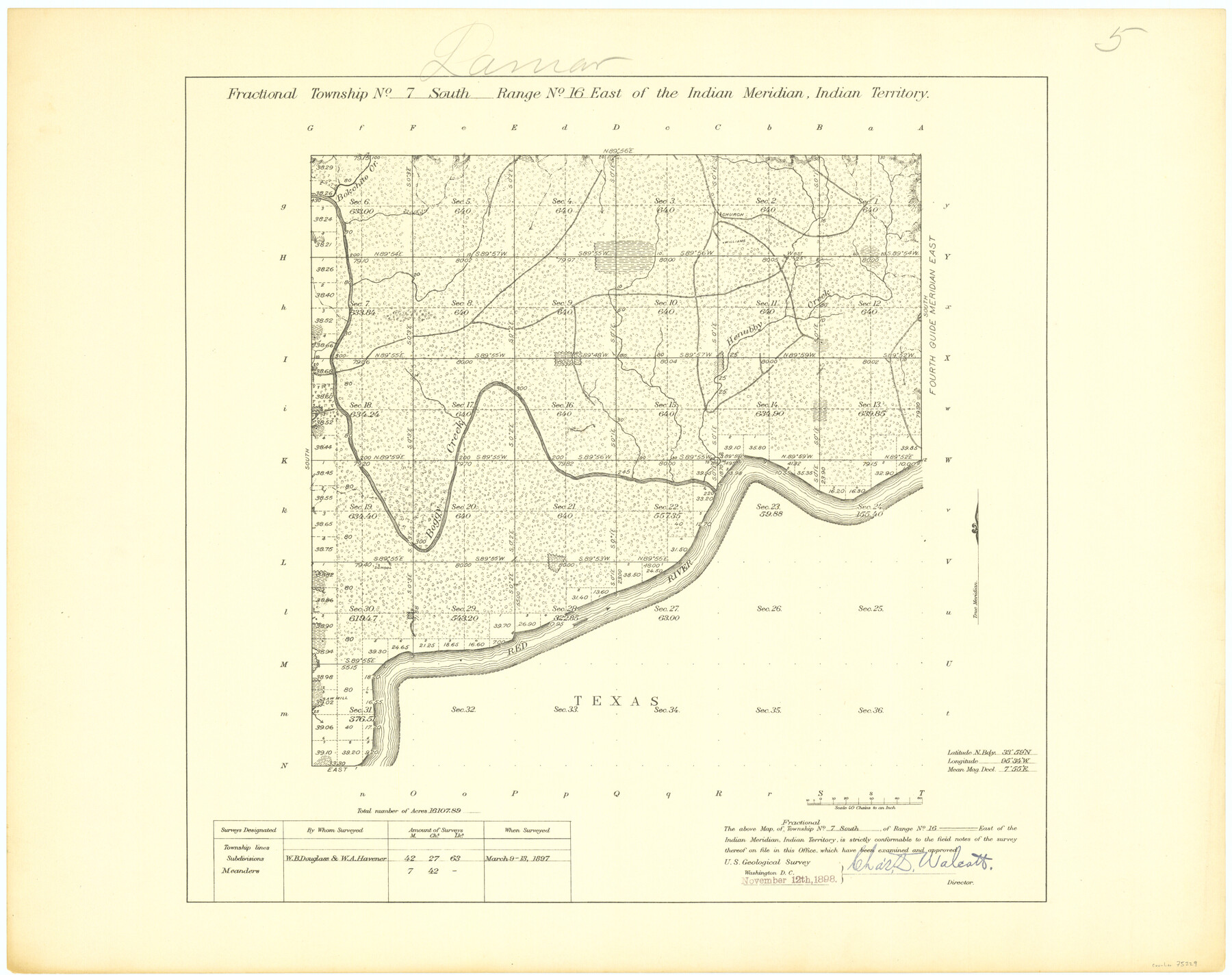
Fractional Township No. 7 South Range No. 16 East of the Indian Meridian, Indian Territory
-
Map/Doc
75229
-
Collection
General Map Collection
-
Object Dates
1897/3/13 (Creation Date)
-
Subjects
Texas Boundaries
-
Height x Width
19.2 x 24.2 inches
48.8 x 61.5 cm
Part of: General Map Collection
Dimmit County Working Sketch 27

Print $20.00
- Digital $50.00
Dimmit County Working Sketch 27
1956
Size 20.3 x 23.0 inches
Map/Doc 68688
Kendall County

Print $20.00
- Digital $50.00
Kendall County
1946
Size 41.6 x 35.9 inches
Map/Doc 1872
Reeves County Rolled Sketch 37

Print $20.00
- Digital $50.00
Reeves County Rolled Sketch 37
2017
Size 22.9 x 17.1 inches
Map/Doc 95203
Brewster County Working Sketch 62

Print $20.00
- Digital $50.00
Brewster County Working Sketch 62
1956
Size 22.7 x 20.2 inches
Map/Doc 67663
Cooke County Working Sketch 5

Print $20.00
- Digital $50.00
Cooke County Working Sketch 5
1928
Size 16.1 x 17.2 inches
Map/Doc 68242
Fannin County Sketch File 14

Print $6.00
- Digital $50.00
Fannin County Sketch File 14
1866
Size 14.5 x 9.6 inches
Map/Doc 22464
Map of Permanent Lakes & Marshes in Calhoun, Victoria & Jackson Counties for Mineral Development

Print $20.00
- Digital $50.00
Map of Permanent Lakes & Marshes in Calhoun, Victoria & Jackson Counties for Mineral Development
1937
Size 31.3 x 37.2 inches
Map/Doc 3021
Medina County Rolled Sketch 23

Print $20.00
- Digital $50.00
Medina County Rolled Sketch 23
Size 30.4 x 42.6 inches
Map/Doc 89063
Kerr County Sketch File 23

Print $8.00
- Digital $50.00
Kerr County Sketch File 23
1959
Size 14.2 x 8.8 inches
Map/Doc 28901
Dimmit County Sketch File 19

Print $28.00
- Digital $50.00
Dimmit County Sketch File 19
1886
Size 13.4 x 8.8 inches
Map/Doc 21088
Flight Mission No. CUG-3P, Frame 168, Kleberg County

Print $20.00
- Digital $50.00
Flight Mission No. CUG-3P, Frame 168, Kleberg County
1956
Size 18.6 x 22.3 inches
Map/Doc 86288
Morris County Sketch File 2

Print $4.00
- Digital $50.00
Morris County Sketch File 2
Size 12.8 x 8.3 inches
Map/Doc 31965
You may also like
[Map showing Block 35, Townships 1N-5N]
![93207, [Map showing Block 35, Townships 1N-5N], Twichell Survey Records](https://historictexasmaps.com/wmedia_w700/maps/93207-1.tif.jpg)
Print $40.00
- Digital $50.00
[Map showing Block 35, Townships 1N-5N]
Size 22.8 x 83.0 inches
Map/Doc 93207
Brazoria County Working Sketch 26

Print $20.00
- Digital $50.00
Brazoria County Working Sketch 26
1968
Size 33.2 x 35.4 inches
Map/Doc 67511
Deaf Smith County Sketch File C

Print $28.00
- Digital $50.00
Deaf Smith County Sketch File C
1902
Size 11.5 x 8.9 inches
Map/Doc 20639
Jones County Sketch File 1

Print $20.00
- Digital $50.00
Jones County Sketch File 1
1857
Size 17.8 x 30.3 inches
Map/Doc 11894
Bosque County Sketch File 22

Print $4.00
- Digital $50.00
Bosque County Sketch File 22
1863
Size 13.8 x 8.5 inches
Map/Doc 14804
Live Oak County

Print $40.00
- Digital $50.00
Live Oak County
1899
Size 52.1 x 37.5 inches
Map/Doc 78423
Presidio County Sketch File 74

Print $8.00
- Digital $50.00
Presidio County Sketch File 74
1946
Size 11.4 x 8.8 inches
Map/Doc 34687
Schleicher County Sketch File 46

Print $4.00
- Digital $50.00
Schleicher County Sketch File 46
1958
Size 3.7 x 8.8 inches
Map/Doc 36554
Coryell County Sketch File 10

Print $6.00
- Digital $50.00
Coryell County Sketch File 10
1861
Size 8.6 x 7.2 inches
Map/Doc 19361
Leon County Working Sketch 7

Print $20.00
- Digital $50.00
Leon County Working Sketch 7
1913
Size 13.7 x 16.7 inches
Map/Doc 70406
Kimble County Working Sketch 62

Print $20.00
- Digital $50.00
Kimble County Working Sketch 62
1964
Size 38.0 x 29.7 inches
Map/Doc 70130
Flight Mission No. BRE-2P, Frame 22, Nueces County

Print $20.00
- Digital $50.00
Flight Mission No. BRE-2P, Frame 22, Nueces County
1956
Size 18.7 x 22.6 inches
Map/Doc 86731