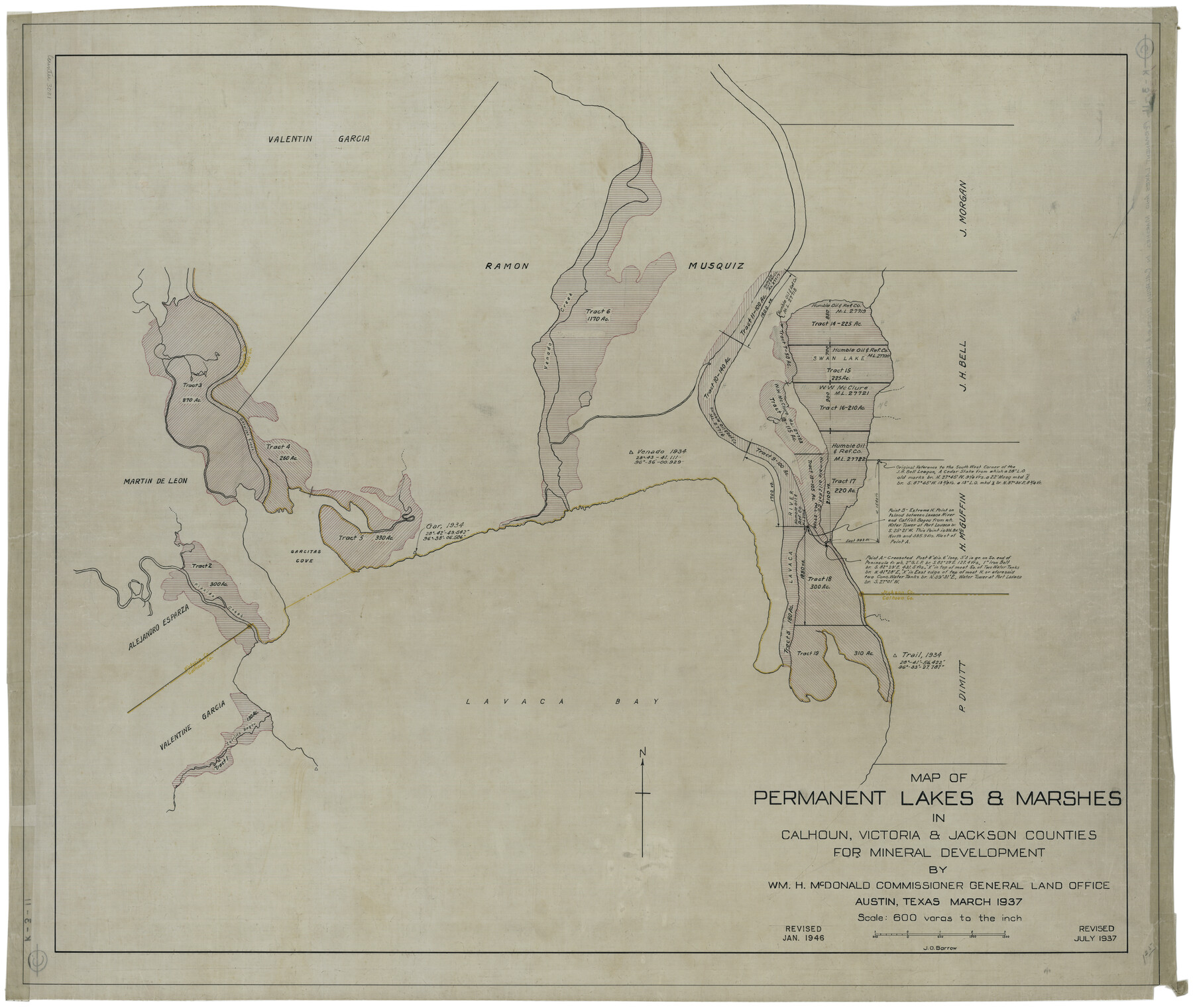
Map of Permanent Lakes & Marshes in Calhoun, Victoria & Jackson Counties for Mineral Development
K-3-11
-
Map/Doc
3021
-
Collection
General Map Collection
-
Object Dates
1937 (Creation Date)
-
Counties
Calhoun
-
Subjects
Energy Offshore Submerged Area
-
Height x Width
31.3 x 37.2 inches
79.5 x 94.5 cm
Part of: General Map Collection
Flight Mission No. DQN-2K, Frame 64, Calhoun County

Print $20.00
- Digital $50.00
Flight Mission No. DQN-2K, Frame 64, Calhoun County
1953
Size 18.6 x 22.3 inches
Map/Doc 84256
Flight Mission No. BQY-4M, Frame 56, Harris County

Print $20.00
- Digital $50.00
Flight Mission No. BQY-4M, Frame 56, Harris County
1953
Size 18.6 x 22.4 inches
Map/Doc 85265
Cass County Working Sketch 35

Print $20.00
- Digital $50.00
Cass County Working Sketch 35
1982
Size 23.5 x 44.8 inches
Map/Doc 67938
Red River County Working Sketch 63

Print $20.00
- Digital $50.00
Red River County Working Sketch 63
1973
Size 43.6 x 37.0 inches
Map/Doc 72046
Andrews County Working Sketch 33

Print $20.00
- Digital $50.00
Andrews County Working Sketch 33
1990
Size 32.9 x 29.7 inches
Map/Doc 67079
Gregg County Rolled Sketch 15

Print $40.00
- Digital $50.00
Gregg County Rolled Sketch 15
1941
Size 42.7 x 57.1 inches
Map/Doc 9066
Flight Mission No. BRE-3P, Frame 36, Nueces County

Print $20.00
- Digital $50.00
Flight Mission No. BRE-3P, Frame 36, Nueces County
1956
Size 18.5 x 22.3 inches
Map/Doc 86814
Fisher County Sketch File 17

Print $6.00
- Digital $50.00
Fisher County Sketch File 17
Size 11.0 x 12.5 inches
Map/Doc 22587

Map of the Southwest Railway System

Print $20.00
- Digital $50.00
Map of the Southwest Railway System
1883
Size 16.0 x 28.8 inches
Map/Doc 93287
Hydrographic Survey H-6396 of Outer Coast of Padre Island; Gulf of Mexico

Print $40.00
- Digital $50.00
Hydrographic Survey H-6396 of Outer Coast of Padre Island; Gulf of Mexico
1938
Size 55.4 x 34.0 inches
Map/Doc 2698
Henderson County Boundary File 2a

Print $12.00
- Digital $50.00
Henderson County Boundary File 2a
Size 14.2 x 8.8 inches
Map/Doc 54656
You may also like
Duval County Rolled Sketch 22

Print $20.00
- Digital $50.00
Duval County Rolled Sketch 22
1942
Size 19.5 x 30.0 inches
Map/Doc 5741
McMullen County Sketch File 47

Print $20.00
- Digital $50.00
McMullen County Sketch File 47
1989
Size 24.6 x 21.5 inches
Map/Doc 12066
Map of Maverick County

Print $20.00
- Digital $50.00
Map of Maverick County
1875
Size 36.3 x 23.7 inches
Map/Doc 3849
[John Walker, south part B9 and vicinity]
![90330, [John Walker, south part B9 and vicinity], Twichell Survey Records](https://historictexasmaps.com/wmedia_w700/maps/90330-1.tif.jpg)
Print $20.00
- Digital $50.00
[John Walker, south part B9 and vicinity]
Size 32.7 x 24.1 inches
Map/Doc 90330
Reeves County Working Sketch 7

Print $20.00
- Digital $50.00
Reeves County Working Sketch 7
1946
Size 36.7 x 43.9 inches
Map/Doc 63450
Laneer vs. Bivins, Potter County, Texas

Print $20.00
- Digital $50.00
Laneer vs. Bivins, Potter County, Texas
Size 21.4 x 18.8 inches
Map/Doc 93102
[Untitled Map of Baja California & West Coast of Mexico]

Print $20.00
- Digital $50.00
[Untitled Map of Baja California & West Coast of Mexico]
1541
Size 11.1 x 16.7 inches
Map/Doc 97353
San Jacinto County Sketch File 12

Print $4.00
San Jacinto County Sketch File 12
1873
Size 9.7 x 8.2 inches
Map/Doc 35720
Pecos County Working Sketch 103

Print $40.00
- Digital $50.00
Pecos County Working Sketch 103
1971
Size 43.4 x 51.4 inches
Map/Doc 71576
Shelby County Sketch File 14

Print $4.00
- Digital $50.00
Shelby County Sketch File 14
1872
Size 9.8 x 8.9 inches
Map/Doc 36622
Tarrant County Working Sketch 16

Print $20.00
- Digital $50.00
Tarrant County Working Sketch 16
1991
Size 14.5 x 23.9 inches
Map/Doc 62433
Wichita County Working Sketch Graphic Index

Print $20.00
- Digital $50.00
Wichita County Working Sketch Graphic Index
1971
Size 36.7 x 38.5 inches
Map/Doc 76739